
|
|
Mountain/Rock |
|---|---|
|
|
44.94170°N / 118.2298°W |
|
|
8646 ft / 2635 m |
|
|
Overview
This page groups four closely approximate peaks in the Anthony Lakes vicinity of Elkhorn sub-range of the Blue Mountains. The middle two Angell Peak (8,646 ft.) and Lees Peak (8,626 ft.), are the highest, with The Lakes Lookout (8,522 ft.) to the west and an unnamed peak (8,538 ft.) to the east. These peaks are grouped because the four exist on a line less than 1.5 miles long and after Angell Peak have a prominences ranging from 222 feet to 358 feet.Angell Peak and Lees Peak form the bulk of the group and are best accessed from the Hoffer Lakes basin to the north. The Lakes Lookout is also accessed from the north and west via a combination road/trail hike originating from Anthony Lake. Point 8,538 is more remote requiring an approximately 3 mile hike on trail 1611, east and south of Anthony Lake. The south side of all peaks can be accessed via Crawford Basin Trial 1612, which is accessed on the west flank of The Lakes Lookout via road 7300-187 (Chicken Hill road). Generally the south side of Angell Peak and Lees Peak are extremely rugged and not the recommended way to summit these peaks unless someone is into very difficult scrambles. The north side of the block has more sheer cliffs, but the vertical lift is not as great and there are some easier slopes as well. Refer to the routes section for more specific information about accessing these peaks.
This portion of the Elkhorn Range is composed entirely of granite that has a very shattered and precipitous nature. This is especially so on the south slopes where finding routes through the jumbles of often impassible rock make scrambles to the top very challenging. Retracing steps to avoid technical rock is common place. The north scramble routes are generally more straightforward. For an excellent account of the geology of this portion of the Blue Mountains refer to the Overview section of the Gunsight Mountain page.
The peaks are briefly summarized from west to east in the following sections:
 |  |  |  |  |
The Lakes Lookout (8,522 ft.)
This peak has two points, one (the eastern) of which has debris from an old lookout just below the summit rocks. A trail goes to the top and many people visit from the crowded Anthony Lake basin. Litter from hikers along with the wood, glass and wire from the old lookout are strewn about making this a pretty messy mountain. The second (western) point is just slightly smaller with some difficult rock to reach the top from the trail. The north side of both these points offers some cliff faces for the technical climber. To the east a small saddle separates The Lakes Lookout from Lees Peak. A scramble to Lees appears doable, but would be a challenge through highly fragmented upright blocks of granite. |  |  | 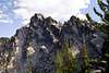 |  |
Lees Peak (8,626 ft.)
Though a bit shorter than Angell Peak, Lees Peak is generally the more rugged and difficult mountain. It is composed of multiple small granite towers that collectively form the bulk of the mountain. Most break to the south side and are difficult to pass through, but the highest one easily accessed from the north via the saddle between Lees Peak and Angell Peak. However, the summit tower will require at least one difficult move to reach the top via the easiest path. | 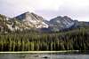 | 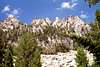 |  |  |
Angell Peak (8,646 ft.)
The highest point of the group is very easily climbed via Hoffer Lakes and the gentle saddle between it and Lees Peak to the west. The south and east sides provide very difficult scrambles or technical climbs. Another way is via the gentle ridge that connects to Gunsight Mountain if one has climbed that mountain and wants an extended hike. The east ridge off the peak is formed of a spectacular series of towers and fins down to Angell Pass, which separates this peak from Pk. 8,538 to the southeast. |  |  |  |  |
Pk. 8,538
This point is east across Angell Pass from Angell Peak. The ridge between the two points is highly technical with several towers or shark fins to scale, thus a traverse from Angell Peak is not recommended. Point 8,538 is best reached where the Elkhorn Crest Trial, 1611 crosses the pass. This point forms a classic pyramid of rugged, much jumbled granite that terminates in a vertical black tip. The dense forest of tangled and stunted subalpine fir and whitebark pine twists and sprawls from the rock to add another difficulty to climbing this peak. |  |  |  |
Getting There
Whether coming from the north or south on Interstate 84, take exit 285 at North Powder and head west on North Powder River Lane (county road 101) for 4.0 miles. Turn left on Ellis Road and continue for 0.6 mile to the junction with the Anthony Lakes Highway. Turn right on the Anthony Lakes Highway and continue for 15.7 miles to the left turnoff to Anthony Lake Campground. Continue for about 100 yards then take a right, following the signs to the day use parking, which is on the southwest corner of the lake.*Refer to the routes for directions beyond Anthony Lake.
Red Tape
None if you park in the day parking lot at Anthony Lakes.Parking in the designated lot for the Elkhorn Crest Trail 1611, requires a Northwest Forest Pass, which cost $5 ($30/year) and can be purchased all all local Forest Service offices and at many area businesses. This trailhead is found by turning left off the highway just before the turn to Anthony Lakes Campground.
When To Climb
Most people climb the mountain from late July to October. Winter ascents are possible, but take additional skill and equipment. The paved highway to the ski resort makes this area more accessible than most during the winter. Snow can occur at any time of the year.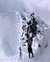 |  | 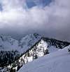 |  |
Camping
These peaks are very close and accessible to the Anthony Lake Campground. Smaller campgrounds very close to Anthony Lake are found at Grande Ronde Lake and Mud Lake. These are off the highway just west of the Anthony Lake turnoff. Back country camping is allowed anywhere in the vicinity. Wherever you are the mosquitoes will be heavy. |  |
Mountain Conditions
Current mountain conditions can be obtained from the US Forest Service:Baker Ranger District
3165 10th Street
Baker City, Oregon 97814
(541) 523-4476
NOAA Forcast