-
 18596 Hits
-
 78.03% Score
-
 10 Votes
|
|
Mountain/Rock |
|---|---|
|
|
34.11200°N / 118.651°W |
|
|
Hiking |
|
|
Fall |
|
|
2163 ft / 659 m |
|
|
Overview
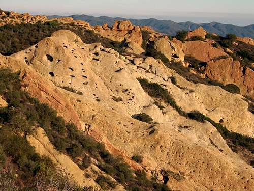
Calabasas Peak towers over Red Rock Canyon, Old Topanga Canyon and bowl-shaped Cold Creek Canyon. An easy hike in Spring and Fall with a 1000' elevation gain; from the top, one can see north into Ventura County, southwest to the Pacific Ocean and northeast to the San Fernando and Simi valleys. The Calabasas Peak Trail passes a variety of interesting geological formations, such as large weathered sandstone outcroppings and colorful rock slabs.
Getting There
From Santa Monica, drive 12 miles north on the Pacific Coast Highway (Highway 1) to Malibu Canyon Road. Turn right and drive 6.5 miles to Mulholland Highway. Turn right and continue 4 miles to the fabled Stunt Road. Turn right again and drive one mile; a dirt pullout is on the right. The trailhead is across the street at the entrance to a gated fire road.From Ventura freeway (Highway 101) in Calabasas, exit on Las Virgenes Road. Head three miles south to Mulholland Highway and make a left turn. Continue 4 miles to Stunt Road. Turn right and drive 1 mile to the dirt pullout on the right.

Red Tape
No permits required, however access to this part of the Santa Monica Mountains recreation area is only permitted sunrise to sunset.
Camping
No Camping Allowed.Weather
In summer the Santa Monica Mountains often penetrate the upper levels of an inversion layer, which means temperatures can be very hot. Spring, Fall and Winter are ideal, with visibility generally better from December through March, especially after periods of rain.Forecast for Calabasas, California.
External Link
Another page on this peak from localhikes.com