-
 20100 Hits
-
 89.2% Score
-
 31 Votes
|
|
Mountain/Rock |
|---|---|
|
|
38.35300°N / 112.357°W |
|
|
Beaver |
|
|
11999 ft / 3657 m |
|
|
Overview
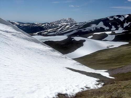
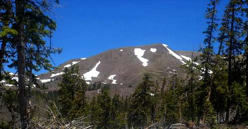
Just 1 foot shy of 12,000 feet, Mount Holly is one of the lesser known peaks in Utah's volcanic Tushar Mountains, the 3rd highest mountain range in Utah. Only the Uinta and La Sal are loftier. Mount Holly and its larger neighbor, Delano Peak, are easy walk-ups in summer and late spring for those comfortable with topos and a compass. There are no trails to the summits of Mount Holly or Delano Peak, however several footpaths traverse their lower flanks. In winter, heavy snows are frequent and the white crowns of the Tushar are visible from much of south-central Utah.Mount Holly is usually climbed in conjunction with 12,173' Delano Peak, the Beaver and Piute county highpoint. Although the area around Mount Holly is easily accesible from June through early October, you will find no crowds, save for herds of grazing elk or mountain goat. You are almost guaranteed to be the only party on the mountain's summit anytime of the year.
If you desire solitude, enchanting beauty and magnificent vistas, then look no further.
Getting There
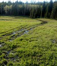
Driving DirectionsDrive to Beaver on interstate 15. Take either of the two exits and head into the center of town. Turn east on Highway 153. Continue 16 miles through a scenic canyon to FS road 123, also know as the Big John Flat road. Not far from mile marker 16, look for a sign on the right side of the road directing you to "Big John Flat." The road is on the left side of across from the sign. Take this dirt road uphill and follow it as it bends left. Stay left at all junctions until arriving at Big John Flat. Camping is allowed and a new restroom facility has been built. It is nearly 5 miles to the Big John Flat camping area and, according to this page by Dean, exactly 5.4 miles to a location "just off the road in some trees (for shade) where you can park or even camp. Car parking spot (38.36650° N, 112.39555° W) 10,480 feet."
As with most summits, having the co-ordinates for the summit in your GPS, or plotting a route on your topo will make travel much easier. If you have 4 wheel drive, continue on up to Poison creek (another half mile or so) to begin your hike.
Hiking Directions
From late spring through fall a footpath is visible, which heads WNW from Big John Flat to Poison Creek. Follow this footpath for 1 to 2 miles along the lower flanks of Mount Holly. Its upper slopes can be seen from points along the trail. You will pass several ravines that channel snow runoff during much of the year. Turn north up one of these ravines as soon as the trail climbs the upper reaches of the treeline. Ascend the ravine to the highest ridge. Once on the high ridge facing north, you will see Delano Peak on your left and Mount Holly on your right. The pyramid shape of Mount Baldy should be far to your left. Follow the high ridge east and begin climbing the upper slopes of Mount Holly. Simply follow your GPS to the summit coordinates. If you do not have GPS, several false summits may become confusing, However once you are on the highest slopes of the peak (above 11,700') it should be clear where the summit lies.

Red Tape
As Scott Patterson puts it, "no red tape nor private property issues are in the Tushars; only mountains."You can camp anywhere you see fit. You can walk freely.
Camping
Finding good campsites is not a problem in the Tushars, even on summer weekends. There are National Forest Campgrounds available at Puffer Lake, but even then you don’t need a reservation on weekends. There are many primitive campsites available throughout the range.Here is a list of nearby accomodations.

Weather
Thanks to Scott Patterson for the following:The Tushar Mountains receive quite a bit of snow, so the normal hiking season is from late June through early October. Late September has some nice colors.
Climbing some of the peaks in winter used to be fairly easy, but in recent years, the access roads have not been kept open due to the closing of the Elk Meadows Ski Resort. All peaks now require several days in winter.
TUSHAR MOUNTAINS WEATHER FORECAST
Below is the climate summary for nearby Elk Meadows at 10,450 feet elevation, and near the trailheads. These are all averages, so expect more variation, but this will give you a good idea about the climate at higher elevations in the area.
| MONTH | HIGH | LOW | PRECIP (in) | SNOWFALL (in) |
| JAN | 26 | 1 | 5.51 | 69.9 |
| FEB | 29 | 4 | 4.31 | 61.5 |
| MAR | 34 | 7 | 4.55 | 64.9 |
| APR | 43 | 14 | 3.88 | 45.7 |
| MAY | 52 | 21 | 3.65 | 23.6 |
| JUN | 63 | 30 | 1.19 | 3.0 |
| JUL | 69 | 38 | 2.38 | 0 |
| AUG | 67 | 36 | 2.92 | 0 |
| SEP | 61 | 28 | 2.11 | 4.8 |
| OCT | 50 | 19 | 1.73 | 17.6 |
| NOV | 36 | 9 | 2.57 | 35.2 |
| DEC | 27 | 3 | 3.66 | 48.8 |
Report Reckless ATVers
Motorists belong on dedicated trails and roads. Please report any ATVers who are off trail.