
-
 15378 Hits
-
 85.87% Score
-
 21 Votes
|
|
Mountain/Rock |
|---|---|
|
|
34.21100°N / 118.1205°W |
|
|
Los Angeles |
|
|
Hiking |
|
|
Spring, Summer, Fall, Winter |
|
|
3207 ft / 977 m |
|
|
Overview: Little Peak with Big History
This is truly a beginner’s peak but with a lot of history under her belt. This rounded summit was once known as “The White City.” It was a grand resort sporting two hotels, the elegant "Echo Mountain House", and "The Chalet", plus the Mt. Lowe Observatory (housing a 13-inch telescope) and even a small zoo. Virtually everything was painted white, the better for visibility from below. The resort was the inspiration of entrepreneur Thaddeus Lowe. Echo Mtn. seen looking south from Castle Canyon Trail
Naturally, visitors to this elegant resort required state of the art means of access. This to was provided by Mr. Lowe. He had trolley lines laid from Lake Avenue in Altadena to a terminus in Rubio Canyon. From the terminus, visitors disembarked from the trolleys onto railway cars called “White Chariots.” They were then “whisked” the 1300 feet up Rubio Canyon to White City. The resort drew 3 million visitors between 1896 and 1936.
“Professor” Lowe’s dream was to extend resort locales and the railway all the way to Mt. Wilson. The dream was never fulfilled. Moreover, reminiscent of a biblical curse, a series of fires and windstorms over the years destroyed the resort structures and observatory. The incline was finally abandoned in 1938.
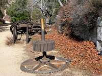
Today, only ruins remain. Yet they are worth a look. Among other remains, you can still see the foundation of Echo Mountain House and the bullwheel for the incline system embedded in cement. Actually, the area where remnants of White City and the railway remain is quite extensive and you can spend a fair amount of time wandering around.
 Remnants of the Mt. Lowe Railway
 Part of the grounds where the resort was located
 Remains of hotel foundation
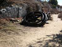 Part of the old incline bullwheel
And though a low summit compared with its sisters further up the San Gabriel front range, the views at 3,207 feet will not disappoint. To the south, you can visually explore the San Gabriel basin and Los Angeles skyline. Looking west, you can see the small range known as the Verdugo Mountains. Right below you southeast is Rubio Canyon and further out from there, the gapping Eaton Canyon. Perhaps the best view is northeast of you where you can look straight up the steep and rugged Castle Canyon to Inspiration Point.
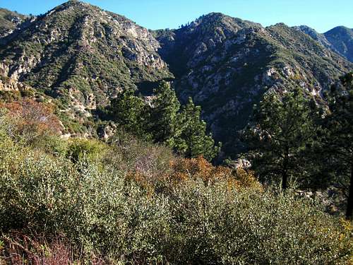 Looking from summit up Castle Canyon to Inspiration Point
The principal route to Echo Mountain is on the Lower Sam Merrill Trail which starts at the top of Lake Avenue in Pasadena.
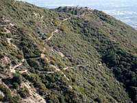 Echo Mtn. and Sam Merrill Trail coming up from Lake Ave.
An alternate route would be from the Sunset Ridge-Mt. Lowe Fire Road. Just below the Cape of Good Hope along the fire road, the 1/2 mile Echo Mountain Trail traverses the route of the railway (remains of the old track bed can still be seen on the trail) from the fire road to the summit.
Getting There
From the 210 Freeway, take the Lake Avenue exit in Pasadena and go north to the end of Lake Avenue, a distance of about 4 miles. The trailhead is on your right at the top of Lake, marked by a sign. You can park along either side of Lake Ave., or along Alta Loma Drive, which street runs perpendicular into Lake Ave. right at the trailhead. Walk past a stone pillar east on a path alongside a fence. In a couple of hundred yards you will come to another trail sign for Echo Mountain. Drop down onto the trail next to this sign and you will soon cross Las Flores Canyon and begin the ascent to Echo Mountain. Beginning of Lower Sam Merrill Trail to Echo Mtn.
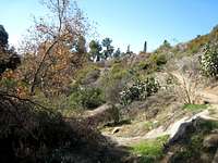 The Sam Merrill Trail crosses Las Flores Canyon at the start of the route
Red Tape
You will not need an Adventure Pass for your vehicle to park at this trailhead because the trailhead is not within the Angeles National Forest.No permits are required for hiking.
Camping
There is no camping available in the immediate vicinity. There are camp sites higher up in the front range such as the Mt. Lowe Campground and the Idlehour Campground among numerous others.When to Climb
Year round. Even in winter, snow is a relatively rare visitor at this elevation.Other Information
USGS Topos Mt. Wilson 7.5There is no water source on the way to Echo Mountain, but the distance is so short that carrying one liter should suffice.