
|
|
Mountain/Rock |
|---|---|
|
|
45.27670°N / 115.9791°W |
|
|
Idaho |
|
|
Hiking, Mixed, Scrambling |
|
|
Summer, Fall |
|
|
8752 ft / 2668 m |
|
|
Overview
 The northeast aspect of Bear Pete Mountain from Pete Creek
 Remains of the lookout
 Source, south fork, Pete Ck
 Lake, south fork Pete Creek
Bear Pete Mountain is the high point of an approximately ten mile long ridge separating the French Creek drainage from the Lake Creek basin. This ridge has at least ten points over 8,000 feet and rises nearly 5,000 feet over the French Creek basin to the west and approximately 2,700 feet above the valley to the east. It has an impressive 2,332 feet of prominence, which places it at number 64 on the Idaho list. The west side of the ridge is fairly steep up to the upper elevations where things gradually top off to the rounded summits. To the east, the ridge forms an escarpment with several vertical cliffs and glacially carved cirques. There are 10 subalpine lakes situated in these, only one of which is accessible by trail. The extended ridge has a total of 18 lakes or ponds, of which only three are named. The northeast face of the summit block is particularly spectacular being formed of extensive cliffs. These are belted longitudinally forming a series of large grooves in the face. The mountain is an easy walkup, mostly on a trail, but difficult technical rocks are found for those who want to try them.
The summit is open with a stunted forest of whitebark pine and subalpine fir broken by glades and subalpine meadows. The lower elevations are mostly uniform lodgepole forest broken up by extensive meadows that are often associated with streams. Areas less likely to burn in the past, such as some riparian areas are filled with larger spruce and subalpine fir forests that are important habitat for moose. Several large and small forest fires have burned in the region over the last several years, converting much of the forest into extensive snag patches and leaving the vegetation in various stages of recovery. These fires have increased wildlife forage and deer, elk and moose are often seen in the area. Wolves, introduced in central Idaho in the 1990’s have increased dramatically and sightings are not that uncommon.
Other things in the vicinity for those who are spending some time here are the viewpoints at Carey Dome and War Eagle lookouts; both of which can be driven to the summit. Also to the Salmon River Canyon can be reached to the north on road 246, though this road becomes extremely rugged and difficult as it descends towards the river. Burgdorf Hot Springs is a public, but rustic hot springs with pools and cabins very near the east base of the mountain. And to the east on Forest road 21 is the historic mining town of Warren, where some minimal services are available.
Getting There
 Road 21 crosses valley from right. Trail ascends Pete Creek at left.
 South ridge of summit
 Bear Pete from Pete Creek
There is good access to trails on the mountain’s east side off of primary roads, but the west side takes more effort to reach with a combination of longer trails and more driving on primitive roads. There are good options for extended loop hikes formed by the main ridge trail 142 and trail 144 up Pete Creek and/or trail 143 up Nethker Creek. From the west trail 145 comes up from the French Creek canyon and is accessed from the Hazard Lakes vicinity.
From McCall, the best way to reach the mountain is to turn north off of Highway 95 onto the Warren Wagon Road (Forest road 21) on the west edge of town. This turn is opposite Lardo’s restaurant. Follow it for 29 miles where the pavement ends and make a left turn on road 246. Pass Burgdorf Hot Springs after about 2 miles and go about 2 more miles to the small campground at Three Mile Creek. For some reason this campground is not indicated on standard Payette National Forest maps, but the marked turn off is immediately north of where road 246 crosses the creek. Drive through the campground to the end where the trailhead is found. There is no real parking area, but pulling off into the trees along side the road isn’t a problem.
The location of this trailhead is at a different location than indicated on the Payette National Forest map or USGS quad maps. Those maps show trail 144 leaving the 246 road approximately 1/3 mile south of Three Mile Creek. Wherever this trailhead was is no longer apparent. The current location in the campground is better situated, but adds a ½ mile to the summit hike.
The hike up trail 144 starts out across a broad meadow, which Lake Creek meanders through. Much effort has been made to fence off the stream and improve water conditions and fish habitat. Cross the bridge and enter the lodgepole forest on the other side. The first two miles are very gentle until the trail turns into the Pete Creek canyon, where the grade increases somewhat, but is still not real steep. After less than two miles the trail turns northward and eventually reaches the headwall of the north arm of Pete Creek. From here the thinning trail climbs about 600 feet to the pass where the 144 trail meets the ridge trail, 142. Continue south on trail 142 on the west side of the main ridge.
The trail continues south the length of the ridge for several miles, but it’s after only one or two miles that one leaves the trail for a run to the summit. There is no particular way to go as it’s all a walkup on this side of the ridge. The north saddle may be the best route if it’s not covered in snow. A broken game trail can be followed much of the way. The maps show a trail climbing the south ridgeline from the saddle on the south end of the summit mound. Historically this trail would have been used to reach the lookout, but is not found now. Little remains of the lookout except for the rock foundation and the typical abandoned debris. This route is approximately seven miles from the trailhead to the summit.
Trail 144 is open to motorcycles and some tracks were seen, but they were old. Early or late in the summer, the trails on Bear Pete Mountain do not get a lot of use, but with the good access, Hot Springs and campgrounds nearby, it is anticipated that during the peak of summer and hunting season, use is probably heavy.
Views From the Summit
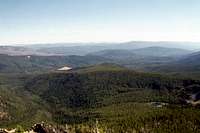
Bear Pete Mountain is fairly isolated from the other extensive mountains of the western Salmon River Range by broad valleys to the west, east and the huge Salmon River Canyon to the north. This separation allows expansive views of the neighboring mountains, which are particularly impressive to the west where the Grassy Mountain subrange lies. To the southeast of the mountain lies a broad valley carpeted by dense forests and the only extensive low country to be had in the region. Here the campgrounds and road access are centered. The main Salmon River Mountains come into the distant view here if the air is clear. To the north the Gospel Hump Wilderness can be seen across the Salmon Canyon. The spectacularly sculpted Lick Creek Mountains dominate the view to the south.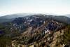


Red Tape
Trail 143 that forms the southern part of a potential loop hike with trail 144 to the north is closed to motorized use according to the standard forest map.Camping
 Unnamed lake near trail
The closest campground for those wishing to hike this mountain is the Three Mile Creek campground located at the trailhead (see Getting There). For some reason this campground is not listed under the campgrounds on the Payette National Forest website. Other close campgrounds include Upper Payette Lake, Jeanette Creek, Chinook, and the small campground at Burgdorf Guard Station, which provides access to the Centennial Trail. Generally there is a fee to camp at these campgrounds, but not just to use the trailheads.
Upper Payette Lake Campground
To reach this campground travel sixteen miles north of McCall on Warren Wagon Road then turn left to Forest Road #495. There are nineteen campground units. Six of them are double units. All have tables, fire rings, handicapped accessible toilets, drinking water through two centrally located hand pumps and hosts, pack in/pack out. The campground also has a group area with 5 sites. In addition to the first come, first served sites, sites at Upper Payette Lake are available for reservation through the Reserve USA website www.ReserveUSA.com or by calling (877) 444-6777.
Jeanette Creek Campground
This campground is thirty-one miles north of McCall on the Warren Wagon Road, and three miles east on Forest Road #246. The small campground has 6 sites, toilets, tables, fire rings, there is trail access, pack in/pack out, but no drinking water.
Chinook Campground
Go thirty-nine miles northeast of McCall on Warren Wagon Road. There are nine campsites with tables, fire rings/grills, toilets, pack in/pack out, but no drinking water.
Burgdorf Campground
To reach this campground, go thirty-one miles north of McCall on Warren Wagon Road, then two miles east on Forest Road #246. There are five sites, sewer hookup, drinking water, handicapped accessible toilet, pack in/pack out. There will be hosts at this campground.
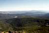
Burgdorf and campgrounds are in the valley belowAt large, dispersed camping is generally allowed anywhere on the Payette National Forest for those not wanting a campground. On the mountain itself there are few opportunities for good camping for backpackers. Perhaps a tent can be pitched close to some of the lakes.
Lodging is also available in the form of private cabins at the Burgdorf Hot Springs. More info on Burgdorf Hot Springs. The cabins are very rustic and you will have to bring some of your own stuff to use them. Call ahead for reservations and info.
When To Climb
The best time to hike this summit is during the summer and fall. Access in the winter and spring is possible, but expect heavy snows. Snowmobile and showshoe outings are possible when the road to Warren is open. Be sure to call the contact numbers below to plan your activity.Mountain Conditions and Additional Information
 Lick Creek Mountains, south of Bear Pete Mountain
Current conditions and local information can be viewed at the Payette National Forest website. They are not always very timely updating this source so you may want to call one of the offices below.
USDA Forest Service
Payette National Forest
800 West Lakeside Ave
McCall ,Idaho 83638
(208) 634-0700
McCall District Ranger Office
102 West Lake Street
McCall, Idaho 83638
(208) 634-0400
NOAA Forecast