
-
 14198 Hits
-
 86.77% Score
-
 23 Votes
|
|
Mountain/Rock |
|---|---|
|
|
35.28444°N / 23.92865°E |
|
|
Hiking, Scrambling |
|
|
Spring, Summer, Fall |
|
|
6942 ft / 2116 m |
|
|
Overview
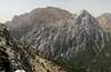
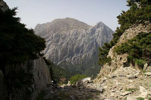 Volakias and Gingilos seen through one of the ravines heading down the Samaria Gorge Volakias and Gingilos seen through one of the ravines heading down the Samaria Gorge |
Βολακιας, in its Latin transcription Volakias, is one of the two westernmost 2000ers of the Levka Ori Range, the White mountains of Crete. Like its neighbour Gingilos it towers high above Europe's longest canyon, the Samaria Gorge and thanks to the popularity of the canyon, millions of visitors have seen its east faces from the canyon floor. Though higher and larger than Gingilos, Volakias stands in the shadow of its lower neighbour. Gingilos with its dolomite east face dominates Xyloskalo, the entry point to the gorge so that wfew people even remember the broad top which peeps out behind the vertical Gingilos rock.
Moreover, Gingilos, perhaps after Crete's highest mountain, Psiloritis is the island's most popular and most frequently climbed mountain. Tour groups climb the sharp edged ledges towards its summit but few head onwards to the neighbour, Volakias. They miss one of the best panoramas, the island has to offer but they also miss a difficult route to the summit and back.
Difficult? Yes - but mainly due to route finding problems. The regular route to Volakias heads across the Gingilos western summit and while guidebooks (and SP's Gingilos page) claim it's just a short traverse to the saddle, which separates the two mountains, this traverse is all but easy. While Gingilos' eastern part is made up from solid dolomite, it's western and southern parts are made up from the usual Cretan limestone, too brittle to place any protection. There is lots of scree on the steep slopes and rockfall is sa serious problem when more than a small party descends the mountain. There are some cairns which indicate a route - but to tell the truth these cairns might also be accidentally placed rocks. With a little experience the traverse doesn't get too difficult but it certainly is not a route for beginners.
There is a second route to Volakias, traversing the Gingilos western slopes from saddle to saddle. However, this route at its beginning (near the saddle between Psilafi and Gingilos) traverses several dolines, collapsed caves which today form crater-like depressions in the slope. Crossing this labyrinth is far from easy and you might find yourself descending far too low to reach the saddle between Gingilos and Volakias. This route is used as a return-route from Volakias.
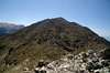
Volakias itself is made up from large limestone blocks and boulders. There is a decent path, which leads close to the summit but near the top you are left to yourself. Volakias has two summits, the northern of which carries a (fallen) summit pillar. Nevertheless the southern one appears to be the higher one. It can be reached by somewhat exposed rock hopping along the connecting ridge.
|


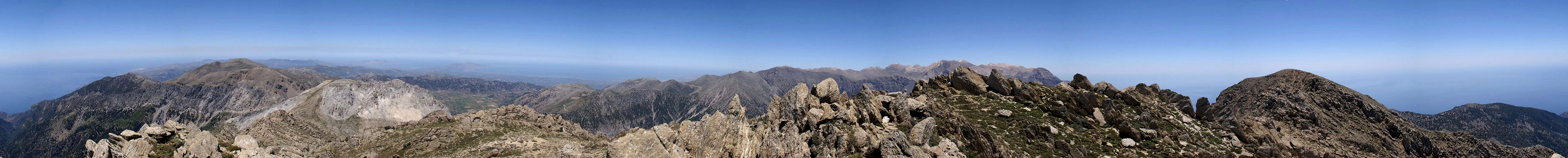
The 360° summit panorama
  |
Getting There
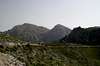
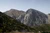
 Omalos Plain
The starting point for a climb of both Gingilos and Volakias is Xyloskalo, the parking lot at the entry to the Samaria Gorge. The lot is located aat the southern end of the Omalos plain and can be easily reached from Chania, the main city of the north-west of Crete. The road leads through Fournes, from which it climbs to Lakki and onwards to Omalos. At all parts of the road signs lead to either Omalos or to the Samaria Gorge.
|


Red Tape
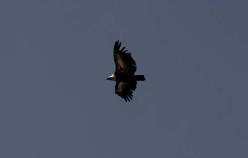 Bearded Vulture
Volakias and Gingilos are located on the western border of the natural park Fysikon Parko Samarias, which encompasses the Samaria Gorge and the surrounding mountains. Staying in the park over night is not allowed and you have to return to the hotels in Omalos or to the Kallergi hut on the eastern side of the gorge. The mountains around the samaria gorge are home to the last specimen of the Golden Eagle and Bearded Vulture, which you might see soar above the gorge. Their eyries are located in the steep faces of the mountains above the upper Samaria Gorge but rather far away from the regular climbing routes. Still, take care not to disturb them, especially in th efirst half of the year when thy raise their little ones.
More information on the park
Accommodation
You can quite easily find hotel rooms and apartments everywhere on the coasts. All European travel companies offer accommodation so a visit to your nearest travel office will find you some. The closest possible hotel is at Omalos, a one hour hike from Xyloskalo, the trailhead. On the eastern side of the gorge there is the Kallergi Hut, also about an hour away from Xyloskalo. To the east of Volakias there is nothing left but rocks and mountains right until you reach Agia Irini at some 500m elevation.Weather conditions
The weather sites on the web only carry information for the cities on the north coast, which are 2000m lower than the mountain top of Volakias. Consequently temperatures will be lower by some 15° C on the summit. Also, especially in winter and spring, the White Mountains are covered in clouds while the coast is clear. On a day like this don't venture in the range - orientation is difficult enough without clouds. The enarest weather link I could find was at Souda near Chania on the north coast of the island, some 60km to the north:Maps & Books
There are quite a number of maps and books out there, which deal with the island of Crete and naturally I don’t know them all. This is the list of maps and books which I used and I appreciate it very much if you can add to itMaps
Unfortunately there are no topographic maps of Crete. The best maps I could find are scaled 1:100000 and contain the main hiking routes on the island. In one case the map showed wrong paths and roads (exchanged them) but in general they were quite useful.
- Kreta / Crete / ΚΡΗΤΗ Western Part
Touring Map
1:100000
Harms Verlag
ISBN: 3-927468-16-9
- Kreta / Crete / ΚΡΗΤΗ Eastern Part
Touring Map
1:100000
Harms Verlag
ISBN: 3-927468-17-7
Books
Since there are no good topographical maps of Crete you should take care to get a good guidebook. The ones I used have good tour suggestions though the descriptions often are somewhat shortish. In one case the maps were wrong but since the above map also showed wrong paths (as well as other maps I saw later) I attribute this to a general problem with the cartography of this specific area. Moreover, the books were issued in 2002 and thus paths might have changed meanwhile. The books are available in German and English.
- Kreta West / Crete West
Gert Hirner / Jakob Murböck (translation: Gill Round)
Rother Verlag
ISBN:
3-7633-4221-4 (German)
3-7633-4803-9 (English)
- Kreta Ost / Crete East
Gert Hirner / Jakob Murböck (translation: Gill Round)
Rother Verlag
ISBN:
3-7633-4004-1 (German)
3-7633-4822-0 (English)