
|
|
Mountain/Rock |
|---|---|
|
|
45.88520°N / 7.94861°E |
|
|
Hiking, Mountaineering |
|
|
Summer |
|
|
9724 ft / 2964 m |
|
|
Overview
The Iron CutterTagliaferro is the highest summit of the watershed between Val Grande and Val Sermenza, the two main branches of Valsesia. Its name, "Iron Cutter" in english, comes from shape of its summit, a sharp edged ridge long more than 60 meters.
This mountain rises over the villages of Rima and Alagna like a dark isolated pyramid, with four symmetrical ridges that delimits four big walls.
The East ridge and the West one sink for more than 1600 meters in the valleys below, giving the impression that the peak wants to threaten the villages at its feet by stretching its huge arms above them.
The South ridge, climbed by the normal route, ascends to the top from Moanda pass at 2400 meters and it forms the massive southern shoulder called Dosso Grinner. The saddle at north of Dosso Grinner is called Passo del Gatto, "pass of the cat", and it's the key passage of the easiest route.
The N-NW ridge, often called simply North ridge, is an huge pillar of rock with an height of 700 meters and it's one of the most classical rock climbing routes of the area.
This last ridge is also the watershed between the NW face and the N wall, the most impressive face of the mountain, rising from the pastures of Alpe Vorco with a prominence of 850 meters and a width of more than 1000.
The other walls are very high as well, but they are covered by vegetations.
The typical dark green color of Tagliaferro's flanks is due to the lichens that cover the rocks and that become very slippery when wet.
This mountain is moreover the first one near Monte Rosa facing clouds generated from the ascending dampness of the planes and lakes at south. Sudden weather changes are frequent on Tagliaferro and numerous accidents, some of them lethal, have afflicted the story of the mountain.
When the sky is clean the summit offers one of of the most spectacular view of this part of the Alps, embracing the big lakes at S, the huge SE face of Monte Rosa, and all the most known summits of the Pennine and Lepontine Alps ranges.
 Tagliaferro from the top of Corno Mud, N-NW
Faces.
From left: S face, W ridge, NW face, N-NW ridge, N wall.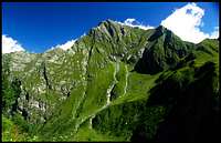 | 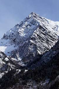 |  |  |  |
Getting There
The trailheads for the summit of Tagliaferro are the villages of Rima in Valsermenza and Alagna in Valgrande.To get there the quickest route is to follow the A26 highway, taking it from Milano or from Torino, exit at Romagnano Sesia and then follow the statal road of Valsesia till Balmuccia, here you have to continue on the main road to reach Alagna or take the provincial road of Valsermenza to reach instead Rima.
 Road Map of high Valsesia
Red Tape
The rocks covered by lichens, that become slippery when wet, and the sudden weather changes have been the cause of many accidents on this mountain, avoid the normal route from Alagna or the ones that demand rock climbing when the weather is unstable.Accomodation
A camping is located in Alagna and there are acdcomodations for all the budgets in the valley.See also the link section.
Huts
Rifugio Ferioli (2200m): it's near Mud pass, under the N-NW ridge of Tagliaferro, it's used to climb the N-NW ridge and the north face both starting from Alagna and from Rima.Alpe Sattal (2100m): this is not a real hut but it offers a bad and breakfast service and can be used to break in two days the hike along the normal route from Alagna.
It's located under the West ridge of Mount Carnera.
The trailhead to reach these huts from Alagna is Pedemonte(1200m), a locality just a few kilometers at north of the main village.
To reach Ferioli hut from Rima(1400m) you have to follow the trail to Mud pass, cross the pass and then get to the hut by a short walk on Alagna's side.
 |  |  |  |
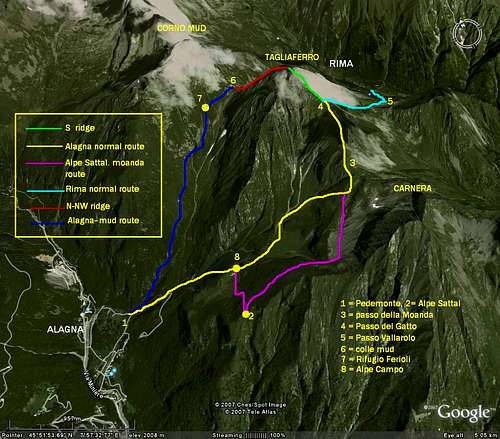
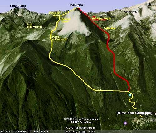
Routes
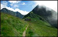
 Tagliaferro from the normal route from Alpe Sattal, on the right the southern shoulder
South Ridge (Normal Route), for expert hikers.
This route climbs the S ridge from Passo del Gatto, 2754m, the large saddle at North of the massive Southern shoulder, Dosso Grinner.
Reaching Passo del Gatto is the only difficult part of the route, especially from the side of Alagna, where there are some exposed passages on a slippery terrain. From the side of rima the path becomes very steep under the saddle, but it is not dangerous.
The two routes, from Rima and alagna, are very long, with more than 1600 meters of altitude to gain.
- From Alagna passing by Moanda Pass.
This route can be dangerous if the rocks and meadows of Dosso Grinner are wet.
From Pedemonte, a lovely Walser village a few kilometers at North of Alagna, follow the trail to Alpe Campo(1932m) and, after the small lake at east of the old buildings of the Alpe, go on following the signed path that crosses the green meadows in the cirque under the walls of Tagliaferro and Carnera, reaching at last Moanda pass at 2400m.
After Moanda pass the trail scramble on the steep west face of Dosso Grinner and there are some risky passages on an exposed terrain. This part of the trail do not demand rock climbing skills, but a secure step and some cold blood. If you suffer for dizziness you should choose the route from Rima.
Once to Passo del Gatto, the route follows the west flank of the ridge till the summit without other difficulties.
If you want to split this long route in two days you can sleep at Alpe Sattal, an hut located on a balcony at the basis of the west ridge of Monte Carnera, reachable form Alpe Campo in less than 30 minutes.
The second day, when you start from Sattal you can go back to Alpe Campo and scramble on the trail described above or you can follow the direct trail to Moanda pass under the North face of Carnera, in this way you don't loose altitude.
- From Vallarolo pass, this is the normal route from Rima and it's the most secure to climb Tagliaferro.
From the village(1400m) follow the trail to Mud pass and Ferioli hut.
Soon a sign near Rio ValMontasca indicates to cross the river toward south. From here the trail turns around the east ridge of the Mountain passing by the buildings of Alpe Scarpia and reaching at last the pass called Vallarolo, at 2300 meters, Between Tagliaferro and the small pinnacle of Moncucco.
From Vallarolo the route climbs the East face of Dosso Grinner and reaches Passo del Gatto. This part of the trail is very steep but more easy and less exposed than the route from Alagna.
The final part of the ridge, From the 2700 meters of the pass till the summit, it's secure and without difficulties.
N-NW Ridge, D+ III, IV and a passage of V- (UIAA scale).
This ridge is usually called simply North ridge, it starts at Mud pass and it's high more than 700 meters.
It’s dangerous when wet, but the rocks are firm and with good weather it offers a pleasant climbing with great views.
North Face, direct route, D+, principally IV and V.
The huge North face of Tagliaferro is an impressive wall with an height of more than 800 meters and a largeness of 1000.
This route has an elevation gain of 850 meters, but it's not frequently repeated, the rock is not always firm and it's very slippery when wet.
 |  |
Links.
Alagna home pageHome page of Alagna, informations about the huts, the trails and the accomodations
www.cappef.com/le%20valli/varie(IT)/tagliaferro.htm
Trip report of an ascent to Tagliaferro by the normal route from Rima, with pics and maps, very nice and useful.
Alpe Sattal
Home page of this lovely place with useful informations and a lot of wonderful pics.
Ferioli hut
Informations about Ferioli hut.