
|
|
Mountain/Rock |
|---|---|
|
|
33.60920°N / 116.5507°W |
|
|
San Bernardino |
|
|
Hiking, Scrambling |
|
|
Spring, Summer, Fall, Winter |
|
|
6423 ft / 1958 m |
|
|
What's the "Point?"
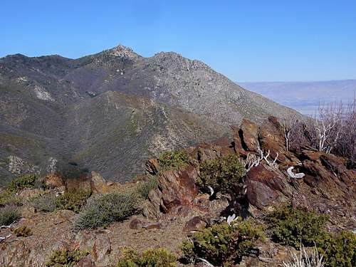
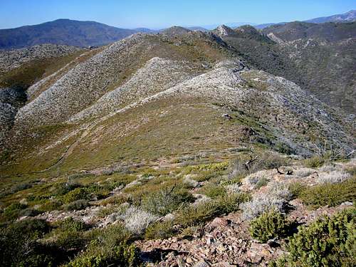
The Pacific Crest Trail winds and wiggles northward through the San Jacinto Mountain Range; making its way from the oaken forests, chaparral, yucca, and cacti desert highland and eventually sub-alpine forests of pine and fir. This southern section of the San Jacinto Mountain Range is known as the Desert Divide, and on its eastern flank, you'll find several deep, eroded, boulder-strewn desert canyons. Rock composition mainly of batholithic rock and granite. A beautiful summer-like December morning atop Ken Point.
The views along this section of the PCT are breathtaking; the entire Santa Rosa range to the south, the San Jacinto Wilderness to the north, the Coachella Valley to the east, and Garner Valley, Thomas Mountain along with Lake Hemet to the west all seen quite clearly year-round. Many of the Hundred Peaks Section peaks below 7000’ elevation are found here and easily accessed off the PCT.
Ken Point is one of the last noteworthy peaks on the southern end of the Desert Divide; not just off the PCT but easily accessed from that trail or via one of a few abandoned mining 4WD roads coming from the south.
It is not quite clear how Ken Point acquired its use-only name. This name was informally given by the HPS, based on a benchmark named "Ken" (1941). It was almost certainly derived from the infamous Kenworthy Mine which once existed, 2.3 air miles to the northwest. This was a "mine" in name only, and it not only never paid off but was one of the great frauds of its age--ruining many of its gullible British backers. Peak was added to the HPS Peak List in 1991.
Getting to Trailhead
From I-15, north or southbound, you can exit in Temecula onto Winchester Road (Hwy 79N) and head north to Hwy 74E and continue on through Hemet and up the slope on pleasant winding mountain roads, complete with competition "S-curves" to Mountain Center. Once you reach Mountain Center at the intersection of Hwy 243 to Idyllwild and Hwy 74 to Palm Springs, stay to your right and on the 74. In approx 10 miles, you will reach Toolbox Springs Road on your left, a sign for Pathfinder Ranch sits on the corner. Turn left here.Or you may exit in Temecula onto Hwy 79S and drive east toward the San Jacinto Mountain range for approx 20 miles, then turn left onto Hwy 371 for Anza. In another approximate 20 miles up a long slow grade to about 4500' through dry rocky terrain, passing the Temecula Olive Oil Company ranch and Cahuilla Casino, you will reach Hwy 74 bound for Palm Springs to the east and Mountain Center to the northwest. Turn left at Hwy 74, there is a nice restaurant on the right hand corner, Paradise Cafe; probably the ONLY good place to eat for many, many miles.
Once you’ve turned onto Toolbox Springs Road, in approx 0.6 miles you will take a left onto Butterfly Peak Road. Approx a quarter mile later, turn right onto Table Mountain Road. Less than a quarter mile later, there will be a narrow paved road on your right marked “private property,” park along Table Mountain Road near here and begin approach on foot on the paved road.
The Hike In & Out
 Pine Mtn and Devil's Postpile
Stay to the right along the trail heading for Gold Hill, it is the only “hump” along the trail that is not mainly granite. There are many faint use trails on the western side, most likely for access to bouldering; this area is littered with hundreds of playful stone!
Once coming just southeast of Gold Hill, you will encounter a fork in the trail; take the left fork, the right fork is the turn-off for Rock Point. Hike up the left fork passed abandoned mining equipment scattered on both sides of trail and an open mine shaft, New Hemet Bell Mine, on your right.
Soon after passing the mine shaft, take the “Prospector’s Trail” on your left, marked by wooden plank sign. This trail becomes steep quickly, switchbacks to a shallow saddle of the ridgeline just south of Butterfly Peak.
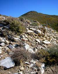 Duck blends on with scenery; look sharp!
 The summit can be found to the south of false summit.
The trail is well-ducked but crazily meanders through Manzanita and chaparral, views of Butterfly Peak will be occasionally obscured but mainly on your left and eventually straight ahead. At this point, you will have the choice to either tag Butterfly Peak by slowly dropping into a small canyon and pass beneath Prospect Wall amongst a boulder field. Continue on ducked trail and climb steep trail to the north onto Butterfly’s eastern ridgeline. Many fallen trees obstruct the path but are easily navigated either around or over. Or circumnavigate around Prospect Wall’s southern end to access an abandoned 4WD mining road. Route finding skills are a must here within a large boulder field and an occasional “duck.”
Either from Butterfly Peak’s southeast ridge (which is a bushwack by any means), or by rounding Prospect Wall’s southern end, hike north along the 4WD road. Follow this road east and then southeast to where it crosses a creek bed. It will eventually fall into the creek bed and wiggle through manzanita and chaparral forests. Just past the creek is a road junction that meets at some sort of coral that is not in use. Take a near U-turn and follow the 4WD road northeast up to a saddle where it intersects the PCT. This trail meanders through forest and steepens as it approaches another trail intersection. There is an old wooden sign at this intersection trying to point out directions – if you can read it. Turn sharply right and follow the trail south through a gate. Stay on trail for approx a mile; you will pass through a forested area and two saddles along the way. Look for a tall “duck” of bleached white stones on the left. A faint use trail goes up through the brush which is easy to pass through as they are barely knee high. Hike up this use trail to the ridge. Turn right and hike up over a false summit and then on to the peak where red summit register can lives.
Ken Point’s summit is an interesting mixture of red, black and white granite towers and boulders. With time on your hands, you can find some Class 4 scramblies or just enjoy the view in any direction. As far away as Mt. San Antonio (Mt Baldy) can be seen on a clear day, and of course the San Jacinto range stretches toward the northwestern horizon.
To escape Ken Point, either traverse back over to false summit and retrace your steps to the trail below, or boot glissade down Ken Point’s face for a better view of the peak’s jagged summit ridge. If you hiked from Butterfly Peak’s summit, you can either scramble/bushwack back the way you came or stay on 4WD drive that traces across the back of Prospect Wall. Continue up the road to its end at the point marked "Prospect" on the map. Contour west from here into a gully. Go over a small rise, intersect the ducked trail of Butterfly Peak and continue on west to Prospector’s Trail and back to trailhead. I found it very easy to get lost in the immense boulder field due to field of vision being blocked by house-sized boulders and manzanita trees.
Admin Stuff
Be mindful of private property and courteous parking at the trailhead. You'll have to traverse along the fenceline of a few properties at onset of trail, try not to look like you're casin' the joints.
Weather Forecast
Compliments of NOAA.