
-
 8122 Hits
-
 87.31% Score
-
 24 Votes
|
|
Mountain/Rock |
|---|---|
|
|
42.16190°N / 123.7831°W |
|
|
Josephine |
|
|
Hiking |
|
|
Spring, Summer, Fall |
|
|
4742 ft / 1445 m |
|
|
Overview
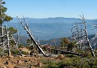

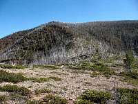
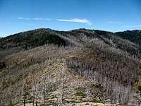
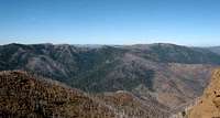
Since the wilderness has had nearly all vegetation completely burned off, the views of the unusual and complex geologic formations have improved. There are a few scattered stands of trees in some canyons and along a few ridgelines. To me it looks like 90% of the trees burned in the 2002 fire and their charred trunks are still standing. Today, the brush and native shrubs are making a comeback, but the trees are struggling to reseed themselves. I see very few tree starts on my hikes in this area. The knobcone pine areas have small tree starts because they have a unique method of reseeding themselves after a forest fire.

Josephine Mountain is not a technical climb, but it is a long day hike. The unique Kalmiopsis leachiana is not visible along the trails that lead to Josephine Mountain. Most of Josephine Mountain was burned in the Biscuit Fire. Some brush is making a comeback, but there aren’t many green trees on the mountain.
From the summit of Josephine Mountain, you can see most of the Kalmiopsis Wilderness and nearly all the named peaks in and around the wilderness. Including Pearsoll Peak, and Big Craggies. During the winter, the area is covered in snow and is not easily accessible.

Getting There
Zero your odometer here and start heading west on this paved road. At 1.0 the pavement narrows, at 2.7 cross the famous green steel bridge over the Illinois River. This green bridge has been the sight of many logging protests and some violence. At 3.1 the pavement ends at the Josephine Campground. At 3.7 stay right and then just stay on the good main road for several miles as it climbs up over 4,000 ft. At 14.3 go left and ignore several spur roads that branch off the main road. At 15.0 miles arrive at the Babyfoot Lake trailhead on the right. There is a nice new vault toilet at the trailhead.
Red Tape
Rogue-Siskiyou National Forest Contact Information
Wild Rivers Ranger District
Joel King, District Ranger
2164 N.E. Spalding Avenue
Grants Pass, OR 97526
Phone Grants Pass (Galice):
Voice: (541) 471-6500
Fax : (541) 471-6514
TTY: 1-866-510-6861
Illinois Valley Ranger Station
26568 Redwood Hwy
Cave Junction, OR 97523
Phone Cave Junction (Illinois Valley):
Voice: (541) 592-4000
Fax : (541) 592-4010
TTY: (541) 592-4011
Camping

National Forest Campgrounds are listed here, some of them in the Wild Rivers Ranger District are quite a ways from the trailhead.
The best place to backpack camp is at Cold Spring between Canyon Mountain and Josephine Mountain. There is water here and a fire pit. The summit is flat and open and there is lots of room to bivy there also. There is no water on the summit.
When to Climb
