
|
|
Mountain/Rock |
|---|---|
|
|
44.09991°N / 107.04769°W |
|
|
Johnson |
|
|
Hiking |
|
|
Spring, Summer, Fall, Winter |
|
|
10534 ft / 3211 m |
|
|
Overview
Hazelton Pyramid of Wyoming’s Bighorn Mountain range is one of a quartet of peaks that dominates the southeast vista (see below) of Powder River Pass (9,677 ft.) on Highway 16. Sharing the same basic north-south ridgeline, all four peaks rise over 10,000 feet, with Hazelton Pyramid as the third in line and the highest at 10,534 ft. Double-pointed Hesse Mountain (10,385 ft.) is the first peak, followed by an unnamed peak (10,372 ft.), and then comes Hazelton Pyramid, and lastly (and the least) Hazelton Peak (10,264 ft.) doglegs to the SE and finishes the ridgeline.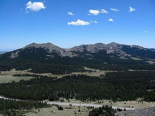 Hesse Mtn, unnamed, and Hazelton Pyramid (left to right). North Fork Powder River meandering in front. --Image by jimmyjay
With the popular Cloud Peak Wilderness stretching beyond the North side of Highway 16, Hazelton Pyramid and his siblings beckon to those who wish to find solitude on a quiet, lonely peak. Only hiking and light scrambling are required for those who wish to scale these mountainsides. What piece of character could be waiting for you on the top of these rocky peaks? There is only one way to find out. But, be careful; the trail is often faint when visible at all. Most of this hike will be charted by map and compass skills. Don’t worry; your effort will be rewarded. You know that it always is.
Getting There
Coming from East or West, you will use Highway 16 to access this area.Coming From the East: Get on Highway 16 at Buffalo, WY
Coming From the West: Get on Highway 16 at Worland, WY
Powder River Pass is the summit of this scenic highway. You will be leaving Highway 16 just East of the pass. The road is Forest Road 29 and it should be posted. As you turn off (south) onto FR29, you will descend into Canyon Park. Powder River Pass will be on your right, and Hesse Mountain will be to your left. Stay right at the first fork in the road. FR29 will follow the North Fork of Powder River for almost 5 miles. All along this road, great sites can be claimed for free camping. This road will eventually finish at a roundabout. This is the end of the road and where you will get out and start hiking. There should be a livestock corral just behind the hill and to the South.
Wyoming Road Conditions:
Red Tape
Hazelton Pyramid resides in Bighorn National Forest land (Buffalo Ranger District.) Backcountry Permits are not required on National Forest lands. Wyoming fishing licenses are required for the streams and lakes.As long as the roads are passable and open, this peak is welcome to visitors. I’m not a local, so I don’t know if these roads get closed in the winter. There is a ski resort to the West, so I imagine the roads usually stay open.
Forest Service Pass & Permit info:
Camping
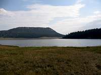 Meadowlark Lake
-Boundless free camping is available along FR29.
-Many Forest Service campgrounds are available all along Highway 16.
-Accommodations can also be found at Meadowlark Lake Resort, Ten Sleep, Worland and Buffalo.
Camping info for Bighorn National Forest:
-Firewood: Firewood is scarce around the campgrounds, but with a short walk or drive off the beaten path firewood is plenteous.
Mountain Conditions
Check the local forecast via this link to NOAA:
Check current fire danger:
Forest Service current snow information:
More current conditions
Avalanche info:
Maps & Peak Data
Tips on the maps:-The National Geographic Trails Illustrated Map of the Cloud Peak Wilderness does not show Hazelton Pyramid. It lies just off the page. Too bad!
-The USGS 1:100,000 series map shows this mountain labeled as Hazelton Peak. Yet, the 1:24,000 series labels this as Hazelton Pyramid. Please be aware of this discrepancy if you see any other sources that call this mountain Hazelton Peak. The guidebook mentioned in the links section also has the name wrong.
Topo Map link by Terraserver:
 Hazelton Pyramid
The USGS Maps for this area are:
1:100,000--Worland, Wy
1:24,000—Hazelton Peak
Peak Data:
Prominence: 1,179 feet
Isolation: 7.97 miles
Wyoming Elevation Rank: 830
Johnson County Elevation Rank: 26
Johnson County Prominence Rank: 4
Trail
Distance: 3.2 Miles onewayElevation Gain: 1,674 feet
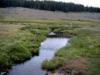 North Fork Powder River
Trailhead: No Restrooms and no water. Trail begins by crossing North Fork Powder River, so water can be treated from it.
From the roundabout follow an old, closed logging road that leads north up a hill. Stay to the left at the first fork. The road will begin to curve around to the East and take you close to the foot of the mountain. The road will continue to curve until it points in a southerly direction. After it plunges into the forest, the road will eventually end. There is no need to travel to the end of the road. Once again, there is no maintained trail for Hazelton Pyramid. Once the logging road gets into the trees, keep an eye out for a few faint trails that lead up the slope. I don't think it matters which faint trail you take, they will all eventually get you through the forest. Please, use your good judgment and navigation skills as you proceed. Remember to turn around often to get a good look of what your course will look like when you come back down from the mountain. I have found that a digital camera comes in handy to visually document your return route. The point is to hike uphill through the forest until you break through the trees onto the grassy slopes of Hazleton Pyramid.
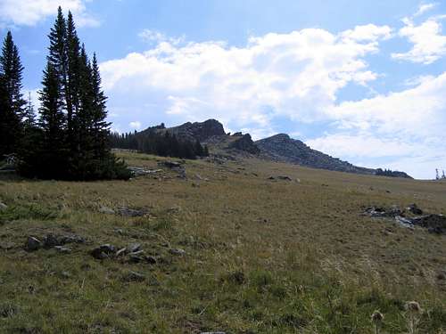 No maintained trail
The slope is steep enough that you can't see the peak initially, but if you just begin to hike up the slope you will begin to see a rocky ridgeline (above) (10,201 ft.), which is your temporary goal. Hazelton Pyramid lies to the SE (behind) of this rocky ridge. Once you are near the top of the ridge, contour around to the North of it toward a gully with scattered trees. Once beyond the rocky ridge you can ascend out of the trees again and back to the ridge top. Hazelton Pyramid should now be to the SE of you with a grassy bowl (below) to the SW.
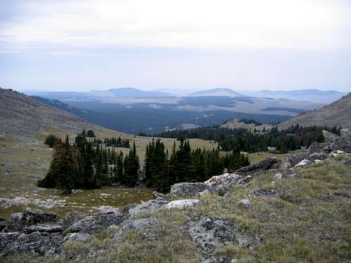 Looking SW over Grassy Bowl from ridge top
Just follow the ridgeline all the way up to the summit (below) of Hazelton Pyramid. The summit has an old USGS Benchmark plate.
On the way down, I traversed through the grassy bowl and to the South of the ridge to avoid the rocky North slope. I thought the route change was worth it. Once again, there is no trail either way.
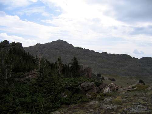 Final Ascent
--See Images for more photo documentation.
This map shows the approximate primary (blue) and secondary (green) routes that can be taken.
View Hazelton Pyramid in a larger map
Wildlife & Fishing
The page sponsor spotted an elk herd on the grassy slopes, pikas all throughout the grassy bowl just below the summit, and a golden eagle perched on the peak scanning all the pikas down below.Bighorn National Forest Wildlife Info:
An assortment of trout can be found in nearby Meadowlark Lake to the West and Dull Knife Reservoir to the South.
-Cutthroat are the only native trout in this area
Get the current local fishing report:
External Links
This hike is also outlined in A Falcon Guide: Hiking Wyoming’s Cloud Peak Wilderness by Erik Molvar. It is available at online outlets like Amazon.com and othersA Falcon Guide: Hiking Wyoming’s Cloud Peak Wilderness by Erik Molvar.
Get topo maps at the USGS online store:
Bighorn National Forest Home Page: