
-
 16918 Hits
-
 93.58% Score
-
 43 Votes
|
|
Mountain/Rock |
|---|---|
|
|
48.46760°N / 113.354°W |
|
|
Glacier |
|
|
Hiking, Mountaineering |
|
|
Spring, Summer, Fall, Winter |
|
|
8164 ft / 2488 m |
|
|
Overview of Appistoki Peak
Layout designed for best viewing on a "1024 x 768" screen.

|
|---|
Appistoki Peak is 8,164 feet high and was named by R. T. Evans, a topographer who worked on the early map of the park. It is reported that he inquired from his Indian guide what word the Blackfeet used for "looking over something," and the guide, misunderstanding the meaning of his question, gave him the name "Appistoki," for the Indian god who looks over everything and everyone.
The name "appistoki" appears to be appropriate for this peak as it truly does look over a lot of territory. Views from Appistoki Peak offer a unique perspective on the Two Medicine Valley, the Plains of Central Montana and into the Nyack Region as well.
Place Names of Glacier National Park states that Appistoki was named a totally different name by George Schultz.
Schultz named this mountain "Iron Shirt or Miskim-asokas(i)". Iron Shirt was a warrior who went on a raid to the southwest and brought back a coat of mail. I personally like this explaination and find it credible.
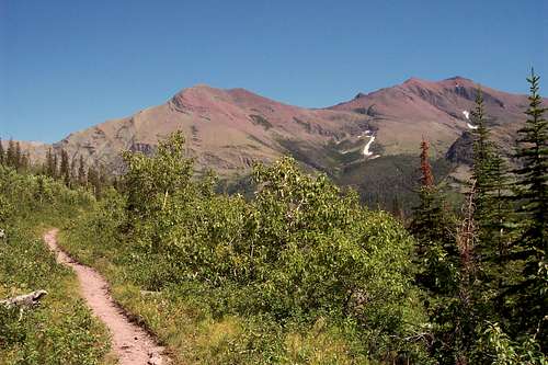
Getting There
 Appistoki Peak from the north shore of Two Medicine Lake.
Appistoki is considered part of the "The Scenic Point Ridge Walk" and located in the Two Medicine Valley in the southeastern corner on Glacier National Park. Glacier National Park, the "Crown of the Continent", is located in northwestern Montana and shares a border with Waterton International Peace Park in Canada.
Getting to Montana is not an easy task, but it is worth the effort. Information on visiting Northwest Montana and all of the other things to do can be found at Visiting The Flathead Valley.
Glacier International Airport serves as the air hub for northwestern Montana. Horizon, Delta Connection and Northwest Airlines service this area.
Rail service via Amtrak arrives daily from Minneapolis or Seattle stops in East Glacier, Essex, West Glacier and Whitefish.
The Flathead Valley is also served by bus service.
If you are interested in rental cars upon your arrival they can be secured in the Flathead Valley near Glacier International Airport.
Other options include: Flying into Great Falls, Montana or even Calgary, Alberta in Canada.
The major highways serving northwest Montana include Highway 2 running east and west and Highways 83 and 93 running north and south. Glacier National Park is located 160 miles north of Interstate 90 which runs through the southwestern portion of Montana.
Click here for Road Information regarding conditions, repairs and delay schedules as well as estimated opening dates.
Driving Instructions From East Glacier, Montana: After reaching East Glacier, Montana on Highway 2 and travel 4 miles North on State Highway 49 to the Two Medicine turnoff. The Scenic Point Trailhead is approximately 8.5 miles from the Highway 49 Junction. The trail to Scenic Point is clearly marked on Glacier Road Map.
Driving Instructions From St. Mary's, Montana: Travel south on Highway 89 to Kiowa Junction, turn right on to Highway 49 and continue 9 miles to the Two Medicine turnoff. The Scenic Point Trailhead is approximately 8.5 miles from the Highway 49 Junction. The trail to Scenic Point is clearly marked on Glacier Road Map.
Red Tape
|
To visit Glacier National Park is to enter a place where Heaven touches Earth
affording brief glimpses into the Wonders of Creation. |
 Appistoki Peak from Two Medicine Lake.
For all of the rules and regulations for Glacier National Park please visit the park website.
Vehicle single entry fee for Glacier National Park is $25.00 for 7 Days, $12.00 per person for single hiker, motor biker or bicyclist. An "America The Beautiful Federal Lands Recreational Pass" for goes for $80.00 which gives entrance to all National Parks, National Forests, BLM, US Fish & Wildlife, and Bureau of Reclamation sites for one year from date of purchase. See Plan Your Visit for other information regarding all of the National Park entrance fee information.
If you are planning on visiting Waterton Park make sure you have a passport to simplify crossing the border.
You do not have to register for day climbs in Glacier National Park but it is recommended. Backcountry travel regulations can be found at Backcountry Travel. There is also information from the Park Service on Mountain Climbing in Glacier.
As with all hiking and climbing in Glacier National Park use caution and practice good manners with the wildlife. You are in bear country. Carry your bear deterrent spray, don’t hike alone and make some noise. For more information please go to the Park's website for Bear Information. The U.S. Forest Service also has helpful information on Grizzly Bear Management.
Route Description
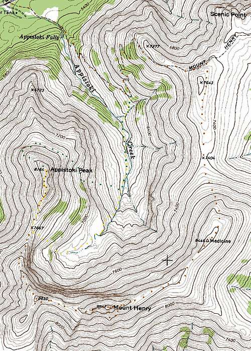 Route Topo. The ascent route is shown in YELLOW and optional descent is shown in GREEN.
Volume Two of Climb Glacier National Park has more details on Appistoki Peak and suggested routes. It can be ordered at Climb Glacier National Park.
Additional Information can be found on the "Route Pages" for Appistoki Peak. Appistoki Peak is mentioned in Edwards’ “Routes Among The Peaks” on pages 315-316 in A Climber's Guide To GLacier National Park.
There are at least two standard ways to climb Appistoki Peak.
Ascent of Appistoki Peak also appears possible from the south shore of Two Medicine Lake as well as directly from the Scenic Point Trailhead. Both of these options may include some off trail bushwhacking.
Option A: The Appistoki Creek Route which follows the creek from a switchback on the Scenic Point Trail.
Option B: If the complete Scenic Point Ridgewalk is taken Edwards states in his guidebook that the trip should take about 10 hours (it took a climbing partner and I about 7 hours to complete but we did not linger at any summits). The route also crosses unnamed peaks and allows access for other peaks in the area such as accessing Mt. Ellsworth on an extended ridge walk.
If the desire is to do Appistoki Peak as part of the Scenic Point Ridge Walk continue up the trail when reaching the first switch back above Appistoki Falls (it is obvious as the great face of Henry can be seen from this switchback) and follow the route on the Mount Henry page. Avoid the temptation to attain the ridge above by climbing through the cliffs above the switchback. It takes much longer and traveling on the trail is easier.
When to Climb and Weather
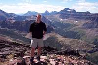
 Appistoki Peak from Medicine Peak.
 Appistoki Peak in June 2009.
It is possible to complete the Appistoki or the Scenic Point Ridge Walk during most months of the year. It would be necessary to ski or snowshoe to this route after the roads close. Roads in the Two Medicine area typically open in the late spring. Click here for Glacier Park Road Status. Alpinists will experience a higher degree of challenge earlier and later in the season. Glacier Park roads close at a moments notice due to poor road conditions and snowfall.
Any climbing or hiking in Glacier is much more pleasant if the weather cooperates. To see the latest weather visit Glacier Park Weather.
The Wind:
The eastside of Glacier Park is notorious for strong winds up to 100 miles per hour being clocked. Winds in East Glacier, Montana just off the continental divide have been strong enough to knock railroad cars off of bridges. Most days in the summer and fall are not that extreme. Check out Glacier Park's What's New Page road conditions and the usual happenings at Glacier National Park. For current weather see Glacier Park Weather.
The Snow:
Montana gets its share of interesting weather. On June 8, 2008 over 2” of snow fell in the Flathead Valley and up to 24” inches of new snow in the Glacier National Park high country.
In some years there is record snowfall in the mountains of western Montana. In the recent years all of the northwest Rocky Mountains have been under severe drought conditions. The winter of 2007-2008 finally broke the string of below average snow fall and there is still snow lingering in the high country in spots that usually don’t have snow in mid summer. This certainly has helped hold the wildfires at bay.Essential Gear and Camping
![Appistoki Peak]() Another view from Appistoki Peak.
Another view from Appistoki Peak.
This is a dry route after leaving Appistoki Creek. Bring enouugh water for the trip. Hiking poles will aide in your ascent and descent while working through Glacier’s wonderful scree! If an early season climb is made an ice axe and crampons may be needed to cross snowfields.
There is a park campground at Two Medicine Lake
Other options for camping include: GNP Campground Information, USFS Campgrounds, Camping on the Blackfeet Reservation or East Glacier Campgrounds External Links
Glacier Mountaineering Society
Two Medicine Trails
Visit Montana
Glacier National Park in Pictures
 Another view from Appistoki Peak.
There is a park campground at Two Medicine Lake
Other options for camping include: GNP Campground Information, USFS Campgrounds, Camping on the Blackfeet Reservation or East Glacier Campgrounds
External Links
Glacier Mountaineering SocietyTwo Medicine Trails
Visit Montana
Glacier National Park in Pictures