
-
 21254 Hits
-
 86.37% Score
-
 22 Votes
|
|
Mountain/Rock |
|---|---|
|
|
48.12396°N / 121.3025°W |
|
|
Snohomish |
|
|
Hiking |
|
|
Summer, Fall |
|
|
6487 ft / 1977 m |
|
|
Overview
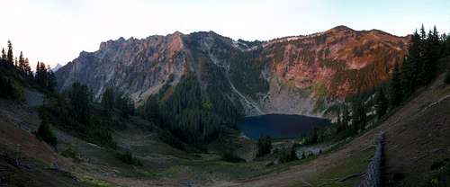 Breccia Peak and Round Lake
Breccia Peak is an 6487 foot Mountain located in the Glacier Peak Wilderness area in Washington. This is not to be confused with the other Breccia Peak located in the Absaroka range in Wyoming. Once a stratovolcano, Breccia has now eroded beyond the point of recognition. Supposedly, Round Lake is where the crater used to be. Accessible by the Mountain Loop Highway, the approach to Breccia Peak follows the Lost Ridge trail. A summit trip will take you along the ridge top past several beautiful isolated alpine lakes. Breccia Peak gets its name from a type of rock. Breccia is a matrix or angular fragments of different sub-types of rocks or minerals.
Getting There
| From Darrington drive south on the mountain loop highway 16 miles to the North Fork Sauk River Road number 308. This road may now be marked as Forest Road 49. It will be the second road on the left about a mile or two past the Mount Pugh trailhead road. Turn left onto the road and drive 3 miles to a small parking lot on the left about big enough for 4 cars. Here you will find the Lost Ridge Trail and sign board. As an alternative driving from the south end of the Mountain Loop Highway through Granite Falls is an option although I’m not sure about the mileage between Granite Falls and the turn off. This will add considerably to the amount of rough rode to be traveled. Watch for killer potholes either way. |  Sloan Peak Sloan Peak |
The Route
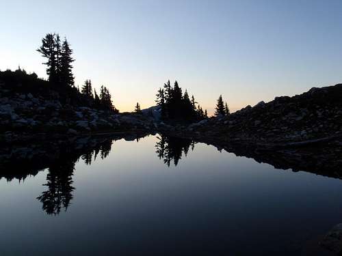 Sunup Lake before sun up Sunup Lake before sun up | Starting from the parking lot at 2000 feet, the trail doesn’t gain much elevation for the first half mile as it follows the often-damp fern and brush covered valley floor. You will know you have reached the base of Lost Ridge when the incline increases and the undergrowth thins out. For the next two and a half miles the trail is well graded and follows switchbacks up to Bingley Gap (4425 feet) and the top of the ridge. Occasionally openings in the trees will reveal massive Sloan Peak towering over the valley. At Bingley Gap there is a great view of Mount Pugh and White Chuck Mountain to the north. From Bingley Gap some head east for Spring Mountain. For Breccia Peak, follow the trail another 2 miles west staying on or near the top of the ridge. You will pass through some open sloping meadows where views to the south become impressive. You will come to a fork in the trail around 5500 feet. The right fork continues along Lost Ridge toward the now non-existent Kennedy Hot Springs. The left fork will take you to the Round Lake overlook saddle at 5550 feet within a few minutes. From the saddle there is a trail leading down to Round lake and this is a good place to camp and swim. |
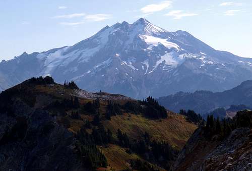
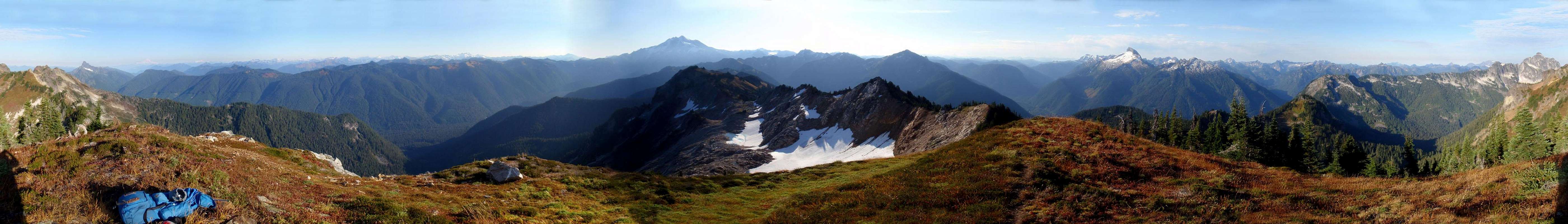
| Going beyond Round Lake overlook toward the summit, the trail peters out and good navigation skills are a must. Take a look at this good quality GPS map of the whole route. Depending on whether there is snow or not, there may be an easier way than the one described here. Follow the ridge top for a half-mile until you are directly west of Sunup Lake. Bushwhack a short while down to Sunup Lake and ascend the slope on the other side, north-east of Sunup Lake. When you reach the saddle, follow the summit ridge with some mild bushwhacking another quarter mile to the summit (6487 feet). You will find the make-shift summit register as a plastic pill bottle nestled in a rock cairn. The summit offers a unique view of nearby Mount Pugh and an in-your-face view of Glacier Peak. There is also a good view of Mount Baker and most of the other Mountain Loop Highway peaks. |  Mount Pugh Mount Pugh |
Further Information
 Glacier Peak Glacier Peak | Due to the fact that mild navigation skills are required and the popularity of nearby Mount Pugh, Breccia Peak is rarely climbed. This should not be mistaken for a lack a beauty or interesting route. Judging by the signatures in the summit register, Breccia’s summit sees an average of 2 people a year. It seems I was the only one to sign it in 2008. This is amazing considering the summit is just one mile from the well-traveled Lost Ridge trail. About three quarters of a mile to the east is neighboring Zi iob Peak. Just below the summit of Zi iob is a mysterious green fiberglass obelisk which stands nearly twenty feet tall. On one side are solar panels. It is just barely visible from the summit of Breccia, as you can see in this picture when it is full-size. Not much information is available as to the origin or purpose of this object. If you know anything about it, please let me know. |
The Summit
External Links
- Matt's trip report on NWHikers.net
- Another trip report featuring Curt And Alexei from NWHikers.net
Current Road Conditions
Darrington Ranger Station
1405 Emens Avenue North
Darrington, WA 98241
(360) 436-1155