
|
|
Mountain/Rock |
|---|---|
|
|
47.12891°N / 12.11451°E |
|
|
Tyrol |
|
|
Hiking |
|
|
Summer, Fall |
|
|
10013 ft / 3052 m |
|
|
Overview
Richterspitze is a 3.052m high summit in Reichenspitzgruppe, eastern Zillertal Alps. Sharp ridges, jagged rocks, glaciers, lakes and creeks form a very nice and impressive landscape. Richterspitze is a not so difficult summit in this area but it is for sure a very nice one. If you start your hike from Krimml you pass the Krimmler Fälle: a row of three waterfalls between 100m and 140m high. With together 380m they are among the biggest waterfalls on earth.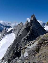 Schwarzhorn
The way from Richterspitze northwards is a more challenging trip on the Reichenspitz block ridge. You pass Zillerspitze 3.092m and get to the highest summit in the area: Reichenspitze 3.303m
Routes
 Krimmler Ache
From Krimml 1.072m you can hike south and pass the nice Krimmler Fälle (waterfalls) and further on to Krimmler Tauernhaus 1.622m (hike through the quite long Krimmler Achen valley or Taxi ride to Tauernhaus). From there you go west through Rainbach valley to Richterhütte 2.367m (5.15h). From the hut west to Gamsscharte 2.972m and north on the block ridge to the summit of Richterspitze (2.00h).
From Gerlospass 1.531m south via Wildgerlos valley to Zittauer Hütte (2.45m). From Zittauer Hütte you pass the Gerlos lakes and go further south to Rosskarscharte 2.690m. On the way you can also take an extra summit: Rosskopf 2.845m, east on the way to Rosskarscharte. From Rosskarscharte you go down to Richterhütte (3.30). From Richterhütte the same way as above.
 Zillergründl
From Zillergrund storage lake 1.850m east to Plauenerhütte 2.363m (1.30h). Further north-east to Gamsscharte 2.972m and north on the block ridge to the summit of Richterspitze (2.00h).
Accommodation
 Richterhütte
Richterhütte (DAV) 2.367m
Zittauer Hütte (ÖAV) 2.328m
Krimmler Tauernhaus (privat) 1.631m
Plauenerhütte (DAV) 2.363m
Getting There
For route via Richterhütte:With car from Inntal highway (A12) on B 169 south and on B 165 via Gerlospass 1.531m to Krimml 1.072m or from east on B 165 via Mittersill to Krimml.
By Bus from Mittersill to Krimml.
For access via Zittauerhütte:
With car from Inntal highway (A12) on B 169 south and on B 165 on to Gerlospass 1.531m.
For route via Plauenerhütte:
With car from Inntal highway (A12) on B 169 south to Mayerhofen.
It is also possible to go to Mayerhofen by train or bus.
From Mayerhofen you can go on to Zillergründl storage lake 1.850m.
Views
 Summitcross
 Reichenspitze
Maps
Alpenvereinskarte 35/3Bundesamt für Eich- und Vermessungswesen 151
Freytag & Berndt WK152
External Links
Waterfalls 2nd Fall