|
|
Mountain/Rock |
|---|---|
|
|
40.76053°N / 110.2886°W |
|
|
Duchesne |
|
|
Hiking |
|
|
12516 ft / 3815 m |
|
|
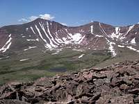
 Val Benchmark from the Kings-Emmons ridge
Overview
Val Benchmark, elevation 12516, is located in the heart of the High Uintas Wilderness area of the Uinta Mountains of Utah. With a prominence of 816 feet it ranks 63 on Scott's list of Utah 12000 footers with over 200 feet of prominence. Anyone who has climbed Kings Peak (13528), Utah's highpoint, has gotten a good look at Val to the ESE as well as many other 12000 footers of the eastern Uintas. From Kings, one can see all the way to Marsh Peak, the easternmost 12000 footer in the Uintas, 29 miles away. View of Val Benchmark from Kings Peak in late March
Val is located 4.5 miles ESE from Kings Peak and 4.5 miles SE from Gunsight Pass. The ridge it lies on lines the south side of Painter Basin, just below Kings Peak to the east. The USGS topo map shows a benchmark on its east side, .15 ENE miles from the summit at N40 45.695 W110 17.160.
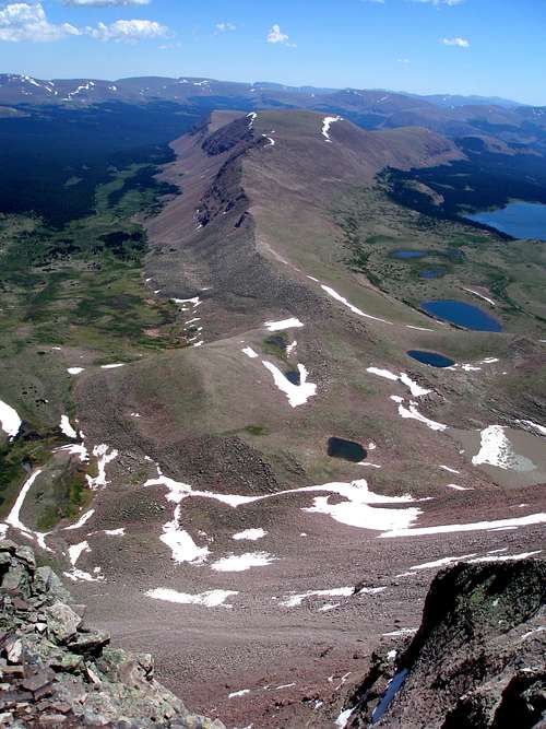
Although the ridge is picturesque, the summit is most aptly described as gently rolling as are many of the 12000 footers in the eastern part of the Uintas. East of Gilbert (13442), Utah's third highest peak, 3.7 miles NNE of Kings, all of the 12000 footers are rounded on top, but may have steep faces.
 Almost at the "summit" of Val Benchmark
The best thing about Val is the great views you get of all the peaks in the Kings-Emmons ridge which according to Scott is the highest continuous ridge in Utah. There is no other place where you can get unobstructed views of every peak from Kings Peak to Mount Emmons so close up. At the south end are South Mount Emmons, Mount Emmons, and North Mount Emmons, all three of which are seen in the picture on the left below. The next two peaks to the north are Roberts Peak and Trail Rider Peak, followed by Painter Peak.
Finally come South Kings Peak and the great granddaddy of them all, Kings Peak. Even though these are Utah's two highest peaks, from the vantage point of Val ridge, they don't look any loftier than any of the other peaks on the ridge.  South Kings Peak and Kings Peak from the Val Benchmark ridge South Kings Peak and Kings Peak from the Val Benchmark ridgeGetting ThereHenrys Fork TrailheadThe trailhead is located south of Mountain View, Wyoming about a 2.5 hour drive from Salt Lake City. If coming from the west on I80, take exit 34 and head towards Fort Bridger. Pass through Fort Bridger until you reach a 4 way intersection with route 414 with a blinking red light. Turn right/south on route 414. If coming from the east on I80, take exit 39 and head south towards Mountain View on route 414. Go straight at the blinking red light. Just south of Mountain View, turn right onto route 410. Follow route 410 for 7 miles until it makes the second sharp right bend where there is a sign for Robertson. At this bend, you go straight onto a very well maintained dirt road. Follow the signs for the Henrys Fork Trailhead which you will reach in about 20 miles. Red TapeNormal wilderness area restrictions apply. The trail to Gunsight Pass is very heavily used by hundreds of hikers wanting to top out on Kings with everyone wanting to camp in the same choice spots, so there are proximity restrictions to some of the lakes in Henrys Fork Basin. Check the sign board at the trailhead to find out what the current restrictions are. Here is a link to a US Forest Service website that lists some general restrictions for the area.CampingThere is a nice but small campground located at the Henrys Fork trailhead and it is free of charge. There are only about 5-7 sites and you will most likely find them full on the weekend. No water is available so you should bring your own.Routes OverviewThere are no quick routes to the summit. It is over 16 miles one way from the nearest trailhead.Henrys Fork Start at Henrys Fork Trailhead and take the trail 9.75 miles to Gunsight Pass. Drop into Painter Basin and head for Trail Rider Pass 3.6 miles away. From the pass, follow the ridge 2.85 miles east to the summit. See the route page for more detail.  Henrys Fork Basin Henrys Fork Basin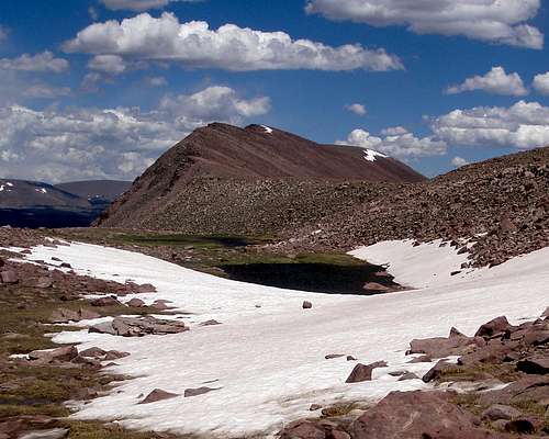 Val Benchmark ridge from near Trail Rider Pass Val Benchmark ridge from near Trail Rider PassFrom Lake Atwood If you ever find yourself fishing at Lake Atwood, SW of Val Benchmark, it looked like it would be a straightforward boulder hop up from the lake to the saddle between Val Benchmark and 12327. The distance from the lake to the saddle is .7 miles and the elevation gain is 1160 feet. Once at the saddle, it is just another .9 miles east and 400 vertical feet to the top. Lake Atwood is commonly reached via the Uinta River Trailhead to the south.  Atwood Basin with Val to the left Atwood Basin with Val to the leftMountain WeatherThe weather in the Uintas is highly variable. Although rare, it can snow even in the middle of the summer. There is typically a chance for afternoon thunderstorms every single day in the summer, but some days the probability is significantly less than others. If you are flexible and watch the Thunder clouds brewing in Henrys Fork Basin Thunder clouds brewing in Henrys Fork Basin |