
-
 24506 Hits
-
 82.48% Score
-
 15 Votes
|
|
Mountain/Rock |
|---|---|
|
|
34.84149°N / 92.48604°W |
|
|
Pulaski |
|
|
Hiking |
|
|
1011 ft / 308 m |
|
|
Overview/Getting there
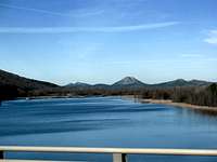
From the summit, one can view Lake Maumelle (Little Rock‘s water supply)to the west. The Arkansas River is seen in the north and to the northeast is where I-430 & the Big Dam Bridge (a pedestrian/bikes only bridge)crosses the river. The cities of Little Rock & North Little Rock have an extensive biking-walking trails system that extend from the Big Dam Bridge all the way down to the Clinton Library and are working to connect to Pinnacle Mountain’s trails.
The park is also the eastern terminus of the 222-mile Ouachita Trail though the trail does not go over Pinnacle’s summit
Trail Route

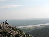 summit
The yellow blazed West Summit Trail has metal markers numbered 1-10 that are equally spread out from the trailhead to near the summit. It is around marker 7 where the trail involves rock hopping so always beware of your footing. The trail gets steeper right on up and passed the #9 marker. At marker 10 is a bulletin board and a fork in the trail/ If you take a right turn you will see the summit of Pinnacle a short climb away and marker #10E. Taking a left at the bulletin will bring to Pinnacle’s rocky ridge and on to the red & white blazed East Summit Trail.
Big Rock & Little Rock

The French Rock became Big Rock Mountain (elevation 580' but towers high above the river)in what is now North Little Rock. At one time stone used to be quarried here and a resort was once atop it in the late 1800’s. The resort closed and became Fort Roots. Fort Roots is now a VA hospital. In addition there is a bike trail at the foot of Big Rock as well as one that go from the base to the top.
Camping
Pinnacle Mountain State Park is open year round and is a day use only park with no camping allowed. However, further down Pinnacle Valley Road is Maumelle Park which has full camping facilites.External Links
Pinnacle Mountain State Park11901 Pinnacle Valley Road
Little Rock, AR 72223
501-868-5806