
|
|
Mountain/Rock |
|---|---|
|
|
47.93925°N / 123.40907°W |
|
|
Clallam |
|
|
Hiking, Mountaineering |
|
|
Spring, Summer, Fall, Winter |
|
|
6247 ft / 1904 m |
|
|
Overview
 Eagle Point
Eagle Point is a mountain summit located in Olympic National Park of Washington State. Eagle Point is conveniently positioned along the middle of popular Hurricane Ridge. In fact, Eagle Point is the highest point of Hurricane Ridge if Obstruction Peak (located southeast of the peak) is not included as part of the major ridgeline (which is a matter of debate, as Obstruction Peak is located at the junction of Hurricane Ridge and Grand Ridge and could be considered as part of either ridgeline). Otherwise, Eagle Point would be the second-highest point of Hurricane Ridge.
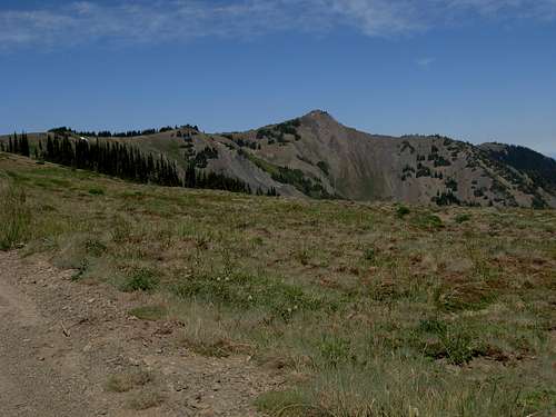
 Looking Down Upper Southwest Slopes
Due to its close proximity to popular Obstruction Point Road, Eagle Point can be summited with little distance or elevation gain. Perhaps the best option for prospective summiters would be to park along the side of Obstruction Point Road where possible, and such nearby pull-outs (where found) only have enough space for one-two vehicles. Then find the point where the southwest ridge of the mountain meets Obstruction Point Road (~5800' elevation) and ascend the southwest ridgeline and slopes to the summit. The hike is YDS Class 2, off-trail, and is only approximately 0.6 miles roundtrip with 450' elevation gain.
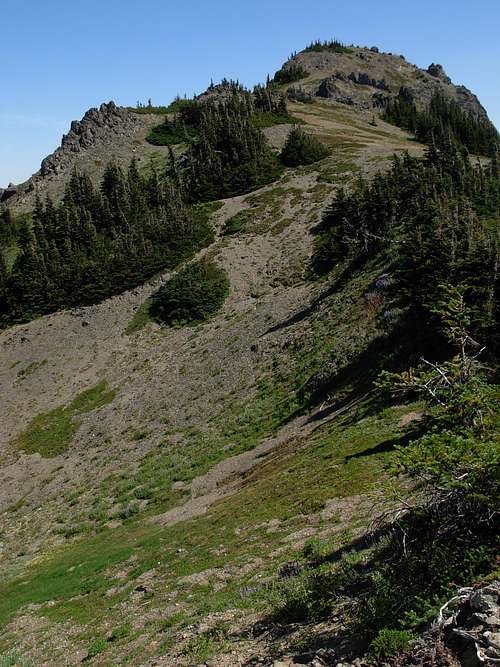 Looking Up Upper Southwest Slopes
The peak can be summited year-round. During late Spring and Summer months, wildflowers are abundant, especially lupine. Use extra caution and care to not step on the wildflowers while climbing the mountain, as they are an integral part of the ecosystem of the Olympic Mountains. However, few trees as on the mountain due to its steep slopes and loose scree terrain. During Winter months, Eagle Point would be a great destination for snowshoeing treks. Centrally located along the middle of Hurricane Ridge, Eagle Point has a great vantage point of Klahhane Ridge (containing Mount Angeles and Rocky Peak) to the northwest and Grand Ridge (containing Elk Mountain and Obstruction Peak) to the southeast.
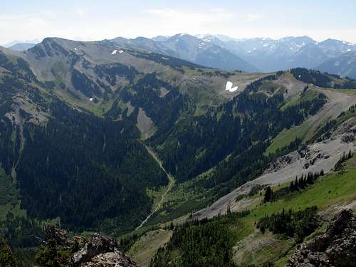 Southeastern View From Summit
There is a USGS Survey Marker disk indicating the location of the true summit of Eagle Point. There is also another USGS Survey Marker disk with an arrow on it pointing to the other disk/true summit.
Getting There
Directions provided lead from various cities to the Hood Canal Bridge, and then to Obstruction Peak from that one location.From Seattle to the Hood Canal Bridge:
Either take a Washington State Ferry from the waterfront at Coleman Dock to Bremerton or Bainbridge Island (see below). You may also choose to drive south to Tacoma on I-5. Take the Gig Harbor / Highway 16 exit and follow to the Hood Canal Bridge.
From Bremerton to the Hood Canal Bridge:
Drive to Highway 3 heading northbound toward the Hood Canal Bridge.
From Bainbridge Island to the Hood Canal Bridge:
Drive west on Highway 305 to Poulsbo. Take the on-ramp to Highway 3 toward the Hood Canal Bridge.
From Everett to the Hood Canal Bridge:
Take a Washington State Ferry from Edmonds to Kingston, and then follow Highway 104 to the Hood Canal Bridge.
------------
Cross the Hood Canal Bridge on Highway 104 and follow the signs to Port Angeles, Washington. Highway 104 merges onto Highway 101 prior to Port Angeles.
In Port Angeles, follow signs to the Olympic National Park. Turn south towards the hills on S Race Street. Follow the signs up to Hurricane Ridge, approximately 17 miles from the Port Angeles Ranger Station. As you reach Hurricane Ridge, just before the parking lot is a dirt road to the south. If the gate is open, drive approximately six miles, exactly one mile further than the PJ Lake Trail/ Waterhole Ski Camp. Find a wide-enough pull-out on the side of the road to park without obstructing passing traffic.
Green Trails Map #135 clearly shows the location of Eagle Point along Obstruction Point Road, although remember that there is no official trail leading to the summit.
Red Tape
Eagle Point is located within Olympic National Park. Park fees, rules, and regulations apply. Backcountry permits are required for overnight stays.Obstruction Point Road is closed during Winter and Spring, usually opening by June during most years.
If climbing this peak, try not to step on the wildflowers and other fragile plant life. It is recommended to stay on rocky scree as much as possible while hiking off-trail.