
|
|
Mountain/Rock |
|---|---|
|
|
48.82293°N / 119.94231°W |
|
|
Okanogan |
|
|
Hiking |
|
|
Spring, Summer, Fall, Winter |
|
|
6849 ft / 2088 m |
|
|
Overview
Corral Butte is a peak located in the Okanogan National Forest of Washington State. Centrally located between much more popular hiking destinations Windy Peak (to the north) and Tiffany Mountain (to the south), Corral Butte offers an easy side-trip for outdoor enthusiasts traveling in the region. In addition, Corral Butte has far-ranging views from its summit, making the short summit hike a worthwhile trip for some. Corral Butte
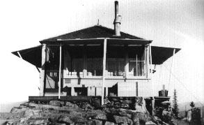
Corral Butte first gained widespread popularity in 1933, when the U.S. Forest Service constructed a fire lookout shelter on the mountaintop due to the summit's 360-degree views of the surrounding region. The lookout, a ground-mounted L-4 cab, was used for 24 years until being destroyed in 1957. Today, several stone stairs on the summit are nearly all that remains as evidence of this lookout. A photo of the original fire lookout can be found here.
 Corral Butte Summit
In 2006, Corral Butte became an important centerpiece for what was one of Washington's largest wildfires in history. On July 24 of that year, a lightning storm near the town of Winthrop (south of Corral Butte) ignited trees that had been dead and dried out due to a bark beetle infestation in the area. Although the nearby towns of Winthrop, Twisp, Conconully, and Loomis were saved from the wildfire due to the diligence of firefighters, much of that region of the Okanogan National Forest became engulfed in flames. By mid-September, what became known as the Tripod Complex fire had covered more than 175,000 acres of forest land, an area approximately 3x the size of Seattle. The fire had spread as far east as Loomis State Forest and as far north as nearly the Canadian border.
 Fire-Ravaged Forest
During both the course of fire's progression and efforts to stop it, firefighters used Corral Butte as a central viewpoint and camp for which to monitor the Tripod Complex fire. The use of Corral Butte's 360-degree views was pivotal to the ultimate success of containing the wildfire. However, before firefighters had established Corral Butte as an operations base, the Tripod Complex fire had already ravaged the slopes of Corral Butte early on, burning down the young pine and spruce forests that blanketed its slopes. The charred and burned remains of those forests are still found throughout the mountain slopes to this day, and it will be decades before it recovers completely.
 Northern View...
Corral Butte can be summited by starting at the intersection of Forest Service Road #39 and Corral Butte Road #255 (~6472' elevation). Walk an old dirt/gravel road (#255) until the road's end just below the final summit slope. Then it is a steep, but very short, hike up a trail to the open rocky summit (6849' elevation). The total walking/hiking distance is 0.75 miles, roundtrip.
Getting There
From Tonasket, WA:1) Drive Okanogan County Road #9437 (Hwy 7) north about 5.5 miles to County Road #9425.
2) Turn east on County Road #9425 and travel about 12 miles to Loomis.
3) From Loomis, continue on County Road #9425 for about 2 miles to County Road #4066.
4) Turn east on County Road #4066, which becomes Forest Service Road #39 (Toats Coulee Road), and continue for 20 miles to Long Swamp Campground.
5) Stay on Forest Service Road #39 by turning south and following for approximately three miles, until reaching the gated road (#255) on the right (west) side of Forest Service Road #39.
 Road #255/ Start Of Road-Hike...
Corral Butte can be found on Green Trails Map #21.
Red Tape
No passes or permits are required to hike Corral Butte.Vehicular travel on the road (#255) leading towards the summit of Corral Butte is prohibited, whether the gate is open or closed. There is enough room to park several vehicles alongside Forest Road 39 near the gate. Do not block the gate.
 USGS Benchmark Found At Summit
Camping
Established campsites are found at Long Swamp Campground, several miles to the north, at the intersection of Forest Road 39 and Forest Road 300.Backcountry campsites can be found at Thirtymile Meadows and Thirtymile Shelter, several miles to the south, along Forest Road 39.
Current weather conditions in nearby Loomis, Washington (east of the mountain):
