
-
 17321 Hits
-
 86.85% Score
-
 23 Votes
|
|
Mountain/Rock |
|---|---|
|
|
21.27000°N / 157.696°W |
|
|
Hiking |
|
|
Spring, Summer, Fall, Winter |
|
|
Overview

Hanauma Bay Nature Preserve is one of the most popular recreational swimming, snorkeling, diving and picnicing areas in Hawai‘i. The bay is legally designated as a State Underwater Park and Conservation District.
There are several accounts of how Hanauma Bay got its name. The word hana means “bay.” The word uma has several meanings, one being “curved.” One translation of Hanauma is therefore “curved bay,” certainly appropriate. (The name is pronounced “ha-now-ma,” with the accent on “now.”)
History
 Hanauma Bay
With the advent of the Kingdom of Hawai’i, the lands around Hanauma became the property of King Kamehameha I. For many years thereafter the bay was the favorite fishing camp of Hawaiian royalty—King Kamehameha V and Prince Jonah Kuhio disported themselves there, among others. In 1883, Hanauma Bay and surrounding lands came into the possession of Bernice Pauahi Bishop, and later her estate, known today as Kamehameha Schools.
Modest development at Hanauma Bay began before the turn of the century. A photograph taken in the 1890’s shows a building on the beach, perhaps constructed for the use of royalty. (The beach in the picture is somewhat narrower than the beach today.) A 1918 magazine article about O’ahu’s arid southeast side mentions that water was available at Hanauma for thirsty travelers. In 1928, the City and County of Honolulu established Koko Head Regional Park—the land encompassing Koko Head, Hanauma Bay, and Koko Crater—by buying it for one dollar from the estate of Bernice Pauahi Bishop. A deed restriction limited its use to public parks and rights of way. Around 1931 a new paved road replaced the old track around southeast O’ahu and a steep walkway with safety rails was installed at Hanauma for the convenience of the few beachgoers who ventured this far from town. In 1941, shortly after the bombing of Pearl Harbor, the U.S. Army strung barbed wire along the beach and stationed soldiers there to repel a possible Japanese invasion. (Among the few remnants of this occupation is a collapsed but still well-camouflaged bunker near the Toilet Bowl. It takes a sharp eye to spot it.) After the war, in 1950, the City and County of Honolulu built a road to the beach and installed new restrooms and showers. Hanauma Bay quickly became a favorite fishing and picnicking park for residents of Honolulu. Swimming at Hanauma, however, was difficult. Except for the two natural lagoons at the north end of the beach, an almost unbroken expanse of shallow reef fringed the shore. A photo from this period shows a narrow channel running through the reef flat, possibly dug at this time to allow swimmers to reach deeper water.
In 1956, the City and County of Honolulu sold the Hawaiian Telephone Company an easement through the bay for the first leg of a new trans-Pacific undersea telephone cable. Barges, trucks, and bulldozers were brought in. The contractor, Hawaiian Dredging, blasted a 200-ft. wide swath through the reef. Tons of coral rock were piled on the beach and removed. Oil covered the water. In a matter of days, the central portion of Hanauma’s beautiful fringing reef, and some of the reef beyond, had been destroyed forever. Such devastation would be unthinkable today, but in those times, it was considered as improvement—the public now had more swimming space. On the positive side, the dynamiting and dredging created a new biological zone inside the reef. Loose rubble left by the blasting became habitat for a host of small invertebrates and the fishes that feed on them, many of which had probably not lived inside the reef in any numbers before. The swimming area (knee-to chest-deep at low tide) gave these fishes ample living space. The channel provided a way in and out, as well as improving water circulation inside the reef. Quite a few species occur today in the artificial swimming area that do not occur in the natural sandy-bottomed lagoons.
With more places to swim and easier access to deep water, Hanauma Bay increased in popularity. Many residents fished there and by the 1960’s few fish of any size were left. In 1967, and not without opposition, the State Division of Fish and Game declared the entire bay a Marine Life Conservation District, prohibiting the taking of marine life, shells, coral, rocks, or sand. One problem remained: surf entering through the wide cable channel was eroding the beach. In 1970, the City Dept. of Parks and Recreation remedied this by partially blocking the channel with an artificial reef of heavy basalt boulders. (The top of this boulder pile is easily seen from shore at low tide.) As part of the same project, and in spite of some community opposition, the City blasted and dredged more reef on the right side of the bay to create a second swimming area in front of the far restroom. Workers buried the dredgings under the beach and covered them with 4, 000 cubic feet of white sand brought in from O’ahu’s north shore. As before, the blasting and dredging created a rubble bottom in which many small animals could live and increased the habitat for larger fishes inside the reef. Also, the new boulder pile sheltered the original swimming area from incoming waves, making it more habitable for marine life. Its outer face became one of the best shallow snorkeling areas outside the reef.
After creation of the marine preserve, snorkeling and fish feeding at Hanauma became hugely popular. Tourists brought in by the busload soon began to outnumber residents on the beach. To make room for everyone the City build an additional parking lot, and by the late 1980’s as many as 10,000 people per day were using the bay. The number of fish in the natural lagoons and artificial swimming areas increased enormously as people fed them bread, peas, and human snack foods. Tossing a handful of fish food into the water caused it to boil with fishes large and small. It was thrilling to stand waist deep with fast-moving animals swirling around—most visitors had never been so close to wild creatures.
Fish feeding, of course, was not the only problem. The beach and nearshore waters were overcrowded. Visitors left their vehicles on the lawn, on the roadways, and on the highway. Commercial tours were monopolizing the picnic facilities. It was out of control. Also, many people believed at the time that beachgoers were killing the coral by walking on it. Although unsubstantiated, this environmental concern prompted action. Around 1990 park authorities began a program to minimize impact on the bay both by reducing the number of visitors and by teaching conservation. Most commercial activities were banned and stricter controls on parking were put in place. When the lot filled, cars were turned away. Meanwhile, a volunteer organization, the Friends of Hanauma Bay, working from a booth on the beach, taught thousands of visitors to care for and appreciate marine life. In 1998 the City began charging admission and parking fees, further reducing the number of visitors. The program was a success, albeit with an unforeseen consequence: local people came in fewer numbers and Hanauma Bay became largely a tourist destination. Park officials hope to reverse this.
In 1999 the City began a three-year carrying capacity study to determine the number of visitors that is environmentally safe. Happily, preliminary results released in June 2000 suggested that beachgoers and snorkelers have had little detrimental effect on marine life. Besides fish feeding, which has ceased, the study identified only a few minor negative impacts: runoff from freshwater showers, and swimmers not using restrooms. It was too soon to determine whether people walking on the reef flat over the years had significantly altered or damaged it.
About 3,000 people now visit Hanauma Bay Nature Preserve each day, making it one of the most visited beaches in the State. To keep the marine environment as natural as possible without further lowering the visitor count, the City and County of Honolulu has moved the snack bar up from the beach, build a new Education Center, and instituted a mandatory training video for first-time visitors. All beachgoers now hear a clear message of preservation, conservation, and safety before entering the water.
Today the City and County of Honolulu administers that part of Hanauma Bay Nature Preserve lying above the high tide line, and the State of Hawai’i Dept. of Land and Natural Resources manages the underwater portion.
Geology
 Hanauma Bay
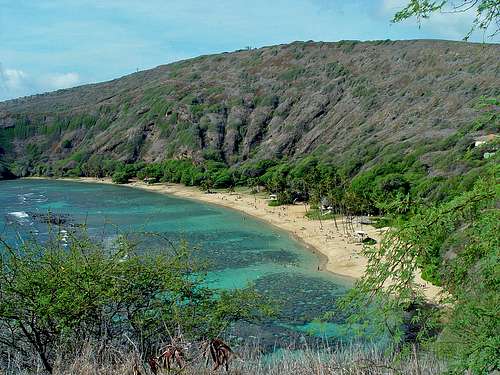 Hanauma Bay
The Hawaiian Islands archipelago is the most isolated island chain in the world. It extends from the Island of Hawai‘i to Kure Atoll in the northwest, a distance of over 1,500 miles. The island Hawai‘i is the youngest of the islands. The Islands are a group of volcanos that have risen up over a "hot spot" of molten rock that wells up from deep in the earth's interior. As the ocean floor slowly moves over this spot, islands are born. They are then carried towards the northwest as they erode and slowly sink below the waves.
O‘ahu first rose above the sea nearly 4 million years ago as the Wai‘anae volcano. The younger Ko‘olau volcano, on the east side of O‘ahu, is about 2.7 million years old. It is larger than the Wai‘anae, and makes up most of the island. Nearly 2 million years ago, the eastern flank of the Ko‘olau volcano collapsed and slid into the sea, leaving the steep mountain range that we see today on the windward side. A quiet period followed the eruptions that formed the Ko‘olaus until energetic rejuvenation-stage volcanism started to occur about a million years ago. This "Honolulu Volcanic Series" created many well-known landmarks including Diamond Head, Punchbowl, and Hanauma Bay.
The present site of Hanauma Bay was underwater 100,000 years ago. The ocean lapped at the base of the Ko‘olaus and a coral reef grew in the area. The youngest craters and cones of the Honolulu Series are part of Koko Head Regional Park, which lies along the Koko rift zone. This region has had the most recent volcanic activity on O‘ahu, and it may not be over yet.
The lava flows that created the Hanauma Bay region started about 40,000 years ago. Koko Crater, the tallest and best preserved cinder and ash cone, is possibly one of the latest volcanic vents. Radiocarbon dates of volcanic rock and reef indicate that the last volcanic event in this area occurred just 7,000 years ago.
About 32,000 years ago Hanauma Bay was created in a violent series of explosions. Hydromagmatic blasts happened when a volcanic vent opened underwater. The erupting magma blew up in bursts of steam, hot gases, rock, coral, and fine ash that blanketed the area. The ash chemically cemented together over time into the firm rock called tuff.
The Bay is now a flooded crater surrounded by several cratered cones. It is likely that its oceanside rim was low to begin with because the ash was carried away by tidal currents and trade winds. The present opening to the sea is probably the result of wave erosion.
The violent explosions that created Hanauma Bay and this southeastern part of the island blasted up through a previously established coral reef. As you walk down to or around the Bay, you will see fragments of white coral limestone and dark basalt rock imbedded in the walls of tuff.
In some areas you may find large pieces of rock and coral that were ejected by eruptions. These large fragments fell into the unconsolidated ash and compressed the layers of ash below them, creating bomb sags in the tuff. If you look carefully, you can sometimes see the shock pattern that the rock left in the tuff. Small crystals of green olivine can also be seen in the crater walls and the sands of the bay, particularly around the "Toilet Bowl" section of the Bay. Olivine is a mineral that is found in areas of recent volcanic activity, like that which happened here. Sea cliffs formed as the crater walls of Hanauma Bay eroded. Wave action, weathering and daily heating and drying of the walls undercut the tuff. This caused large areas to fall into the sea or on the bench (ledge) that developed below the cliffs.
Although the bench was exposed to wave action, water prevented the bench from drying out and weakening. The ledge formed due to the erosion of the cliffs by wind and salt, rather than the bench being degraded by waves.
Getting there
Hanauma Bay Nature Preserve is about 10 miles east of Waikiki just off the main coastal road (Kalaniana'ole Highway, Route 72).In the summer, Hanauma Bay is open daily from 6:00a.m. until 7:00p.m. except on Tuesdays. It is closed all day on Tuesdays. On the second and fourth Saturdays of each month, Hanauma Bay remains open until 10:00p.m.
For our winter session, Hanauma Bay is open daily from 6:00a.m. until 6:00p.m. except on Tuesdays. It is closed all day on Tuesdays. On the second Saturday of each month, Hanauma Bay remains open until 10:00p.m.
Changes are possible at any time; for the latest information call the recorded information line at (808) 396-4229.