

-
 33318 Hits
-
 83.69% Score
-
 17 Votes
|
|
Mountain/Rock |
|---|---|
|
|
39.79590°N / 119.9762°W |
|
|
Washoe |
|
|
Hiking |
|
|
Spring, Summer, Fall, Winter |
|
|
7857 ft / 2395 m |
|
|
Overview


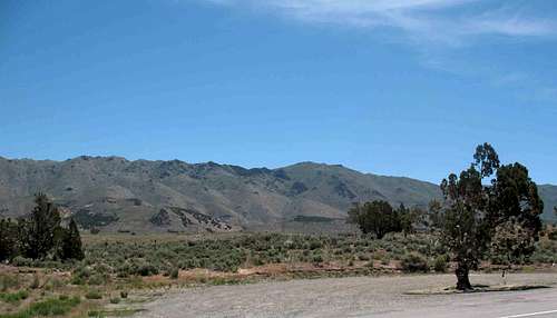
The Petersen Mountains High Point is located in northwest Nevada, north of Reno, and near the California/Nevada state line in Washoe County. Highway 395 is just west of Peterson Mountains. The Petersen Mountains High Point is listed as #101 on the Nevada Prominence list with 2,501 ft of prominence. The topography of the Petersen Mountains is Basin and Range and is similar to much of the high desert landscape of northern Nevada with the range aligned almost exactly in a north/south direction.
The Petersen Mountains are on public land administered by the Bureau of Land Management Carson City District Office. The BLM has provided a nice trailhead on the east side of the mountain that is used to access the summit. The Petersen Mountains have been designated as a “Natural Area” and is mostly covered in grasses, sage brush, and a few aspens up high. The area is fenced and I think this designation is primarily to keep OHV’s from destroying the fragile landscape.
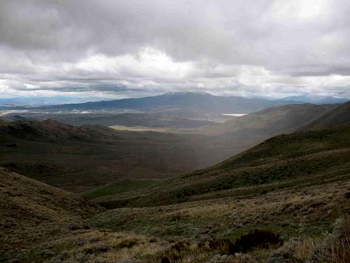
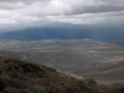
From the summit you get expansive views west into California and to the south towards Reno. Unfortunately it started snowing on me while I was on the summit and I didn’t get any good pic’s of the views.
For details on the hiking trail see the Route information.
NOTE: This page created by Dennis Poulin with Dean Molen added to update some of the content.
Getting There


I approached the trailhead for the Petersen Mountains from Red Rock Road which is east of the mountain. Red Rock Road has an exit from Highway 395 north of Reno. Take this exit and go north about 14 miles on this nice paved road to a turn off on the left (west) side of the road that is a gravel road. This isn’t a great road, but I don’t think you need 4WD unless it is wet and muddy. You won’t be able to see the Petersen Mountains to the west until you get to the top of the first hill. Set your trip odometer and go 2.5 miles and turn left. At 3.0 miles take the right fork and at 3.3 miles stay right. At 3.4 miles turn right into the large parking area for the Petersen Mountains.
For an approach from the west, Bob Burd posted a trip report along with a map of how he was able to make the
west side work. See Bob's fine report HERE.
The Summit stuff

Dennis has provided a nice description of his route and a trip report that I recommend reading. His directions were perfect and led me right to the signed trailhead and probably the best route on the mountain. Peakbagger reports that at least 32 people (as of Sept 2015) have ascended this mountain but that only represents peakbagger members. There is a trip report to the left that had a party of 14 people in the group that the trip report covers. Plenty of people I'm sure and with all the new birdhouses that have been placed (at least 5 by my count and I may have not seen them all), it seems likely that this mountain sees many people every year although not all probably go to the actual summit or sign the register.

Red Tape


No red tape for climbing Petersen Mountain. No OHV’s.
Camping


Developed camping spots in Nevada are not plentiful because virtually the whole state is open to camping anywhere you want. The closest developed campground that I could find is at Pyramid Lake. In 2008 it cost $20/night to camp at the marina plus a $7 permit fee to access the lake.
There is plenty of room to camp at the trailhead, but there is no water available unless you hike up the hill to the spring. Also, there are plenty of motels in the nearby Reno area.
Backpack camping near the summit is feasible, but bring all the water you need.
Mountain Conditions


The Petersen Mountains are accessible all year round. You must use precautions if you hike in the winter and the summer. The mountains get snow in the winter and if you want to climb in the snow, you should make proper preparations. Avalanches would be a remote happening on this mountain on the route I climbed. During the summer, the weather could be unbearably hot and lightning storms are not unusual. Be wary of thunderclouds and bring lots of water in the summer.
The closest town is Reno to the south.
hgrapid - Mar 12, 2012 3:38 pm - Hasn't voted
Trailhead accessDennis, Like you, we approached from the east, which is probably the best way. Indeed there is access from Cold Springs, but it is a longer trek on dirt road. We had a guy check it out on his motorcycle before we went. He says the route noted on your site may be better now, but still recommended another way. This way was Goldstone Road, about 10 miles up Red Rock Road from the Red Rock Road exit off of Highway 395. Goldstone Road is a well graded dirt for the first couple miles or so. It then gets into single track. The road is washed out a bit, but very suitable for 4WD. The problem for us on March 10, 2012 was the fact that some recent snow and apparently little-to-no road maintenance left plenty of divots in the road, and a mud crossing. Still, it wasn’t too bad driving the final 3 miles or so to the actual trailhead with 4WD. Passenger cars; low clearance or 2WD would really struggle. Argosy Road is another way, but if you take a left after the road turns from wide to single track, it leads south to the same place you get to Single-Track on Goldstone Road. So Goldstone is better than Argosy. If you continue on Argosy it gets really hilly, and very difficult even for 4WD.
gret_nelson2 - Dec 1, 2013 11:27 pm - Hasn't voted
Peterson from Red Rock Rd.A group of us hiked this mountain today, December 1, 2013, & we checked the mileage pretty close & found it to be pretty accurate. There is a gas station (Shell) after you take the Red Rock exit & from that station I checked the mileage & got 13.6 so 14 as you actually exit 395 is right on. The left turn from the Red Rock Rd. is a dirt road & at about 0.7 of a mile there is a fork that isn't mentioned. Stay left at this fork. It may be a new ATV or Jeep route. The actual mileage from the turn off from Red Rock Rd. to the Peterson Mountain trailhead is approximately 3.4 to 3.5 miles total. Follow the turns in Dennis's directions to the TH. BTW, take a GPS with you as we had a little trouble figuring out which peak top was Peterson & could have been wondering around if it weren't for my Garmin pointing the way to keep us on the right track. There is a trail that is part jeep, part cattle trail & part hiker trail, but it is not grown over & it can take you toward Peterson. Again, a high clearance vehicle would be best, because there are some areas that have big rocks & ruts that would make it difficult for most vehicles, even something like a Toyota RAV4. There is a register under some rocks at the top. It would help if the next person going to the top would take a small spiral notebook & pen or pencil to add to what is there. Hope this adds to the trip report & helps others who are looking to summit Peterson. Happy hiking.
gret_nelson2 - Apr 6, 2015 12:44 am - Hasn't voted
Peterson Mountain 2015http://adventures.garmin.com/en-US/by/scratchin/peterson-mountain-2015/#.VSIHpRPF9NE This is my Garmin Track with a few photos. We found that the driving directions were a little confusing due to so many roads in the area. The first intersection is at about .5 mile & we stayed left there. At 1.1 miles right; at 2.3 left; 2.7 right. By the time you get to about 3 miles, the trailhead should be visible-green gate & two signs. On the way out from the TH we went a different route-stayed left & the road was better. You will pass cattle watering pond & at first the road has grass in it, but it doesn't get as bad as the other way. However, we meandered around following the road the best we could by keeping an eye on the highway in the distance. We came out at a different location. This turn for next time is about 1.1 miles further than the first turn or about 15 miles from the Red Rock 395 exit. It was a great day to summit Peterson Yesterday.