
-
 15183 Hits
-
 85.87% Score
-
 21 Votes
|
|
Mountain/Rock |
|---|---|
|
|
40.02987°N / 119.9794°W |
|
|
Washoe |
|
|
Hiking |
|
|
Spring, Summer, Fall, Winter |
|
|
7990 ft / 2435 m |
|
|
Overview


State Line Peak is the high point of the Fort Sage Mountains in northwest Nevada, north of Reno, and near the California/Nevada state line in Washoe County. Highway 395 is just west of State Line Peak and the summit is less than a mile from the California border. State Line Peak is listed as #88 on the Nevada Prominence list with 2,690 ft of prominence. The topography of the Fort Sage Mountains is Basin and Range and is similar to much of the high desert landscape of northern Nevada with the range aligned in a northwest/southeast direction.
The Fort Sage Mountains are on public land administered by the Bureau of Land Management Carson City District Office. Much of the Fort Sage Mountains are located in California and the California side of the mountains is a popular OHV area. The BLM has provided a nice Fort Sage Special Recreation Management Area on the California side of the Fort Sage Mountains for OHV and other uses. The BLM statement on Fort Sage area uses is: “In addition to off highway vehicle use, the Fort Sage Mountains are utilized by hikers, horseback riders, rock climbers, hunters and wildlife photographers. Visitors are attracted to the area because of its many unusual weathered granite boulders, volcanic outcrops, expansive desert vistas and good opportunities for viewing wildlife and wild horses.”
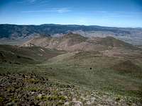
From the summit you get expansive views west into California, to the south towards Reno, the Petersen Mountains to the south, Adams Peak to the west, and Hot Springs Peak to the north.
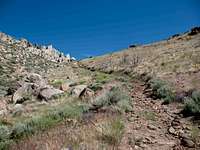
For details on the hiking trail see the Route information.
Getting There


I approached State Line Peak using Highway 395. The small town of Doyle is about 45 miles north of Reno and about 45 miles south of Susanville. It has a signed turnoff from Highway 395. In fact there are at least 2 exits on either side of Doyle and there is a loop road that connects the 2 exits through Doyle. About .75 from either exit on the south side of Doyle on the loop road you will find a road that goes east and immediately crosses the railroad tracks.
From the railroad tracks note your trip odometer and follow this road as it goes left then right, crosses the Long Valley Creek and then turns left again. All this within about .75 mile from the railroad tracks. Just after this last left turn, turn right on the first road. This is Homestead Ranch Road and it goes southeast along the base of the Fort Sage Mountains. So far all these roads are good roads and any 2WD vehicle is ok.
Stay on this road for 5.9 miles from the railroad tracks, where a lesser road goes left up a canyon into the Fort Sage Mountains. This lesser road follows a creek bed for about a mile and then meanders around the mountains while it gains elevation. At 8.0 miles and elevation 5,760, the good part of the lesser road ends, but 4WD continues. I kept going to mile 8.5 and elevation 5,880 where I reached a boulder blocking obstacle on the road. I stopped here and hiked from this spot. There were other obstacles within a half mile ahead that would have stopped my anyway.
Red Tape

No red tape for climbing State Line Peak. Be careful with fire.
Camping


Developed camping spots in Nevada are not plentiful because virtually the whole state is open to camping anywhere you want. The closest campground that I could find is at the Fort Sage Trailhead for OHV’s. There is more camping at Frenchman Lake and back near Susanville or Reno.
There is no real trailhead for this hike. The trailhead depends on how far you want to drive up the canyon. There are some flat spots and there are lots of boulders, cactus, coyote, and sagebrush. There is no water available in the immediate vicinity.
Backpack camping near the summit is feasible, but bring all the water you need.
Mountain Conditions

The Fort Sage Mountains and State Line Peak are accessible all year round. You must use precautions if you hike in the winter and the summer. The mountains get snow in the winter and if you want to climb in the snow, you should make proper preparations. Avalanches would be a remote happening on this mountain on the route I climbed. During the summer, the weather could be unbearably hot and lightning storms are not unusual. Be wary of thunderclouds and bring lots of water in the summer.
The closest town real towns are Reno to the south and Susanville to the north. There are small scattered settlements like Doyle along Highway 395 that may or may not have services including gas. I didn’t see a gas station in Doyle.
mtbaxter - Aug 31, 2015 5:36 pm - Hasn't voted
CHANGE IN ACCESSDaryn Dodge reported that on his October 2014 ascent the route described by Dennis Poulin is now fenced and has no trespassing signs right at the beginning of UN Road B, where it heads up fro the frontage road Homestead Ranch Road. Daryn ended up taking a longer & more XC route from the south. You can read his report at Peakbagger.com Dan Baxter