
-
 15486 Hits
-
 85.36% Score
-
 20 Votes
|
|
Mountain/Rock |
|---|---|
|
|
41.22179°N / 122.30925°W |
|
|
Siskiyou |
|
|
Hiking |
|
|
Spring, Summer, Fall |
|
|
5556 ft / 1693 m |
|
|
Overview
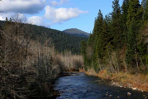 Mount Bradley from the PCT crossing of the Sacramento River
Mount Bradley is the lowest, most minor of the named summits in the Trinity Divide. However, height and size can be deceptive. The peak may appear insignificant compared to nearby behemoths Mount Shasta and Mount Eddy, or even compared to the nearby Castle Crags. From the bottom of the Sacramento River Canyon, one gets a different perspective on the mountain. Rather than being a diminutive peak in the midst of giants, Mount Bradley looms 3,000 feet above the town of Dunsmuir. From near the river, the mountain seems to be the highest peak in the area, anchoring the upper end of the Sacramento Canyon.
What is commonly referred to as Mount Bradley is actually the terminus of a long ridge branching off of the main crest of the Trinity Divide. The outlier splits off of the crest at Gumboot saddle and extends west. “Harry Watkins” and “Castle Peak” are significant summits along this secondary crest. The Mount Bradley Ridge begins west of “Castle Peak” and continues east for another 4.5 miles before dropping abruptly into the Sacramento River Canyon. The peak is actually the lowest of three highpoints that dot the ridgeline. Peaks 5,783 and 5,673 are only slightly higher than the formal Mount Bradley summits and other than the ability to peer into the canyon, equally spectacular views. In most regards, they are preferable destinations, since they lack the fire lookout operated by the Forest Service.
 Mount Bradley and the Castle Crags from Mount Shasta
It is easy to see why a lookout would be placed in this location, offering what may be the most superb view in the area. The Castle Crags are so close one can almost feel their smooth granite spires. The peaks of the Castle Crags Wilderness, the aforementioned “Harry Watkins” and “Castle Peak” as well as “Gray Rock Dome” are all close at hand to the west. A little further to the north, massive Mount Eddy and the length of the Eddy Range, including “Porcupine Peak” can be observed. From this perspective, the incredible bulk of Mount Eddy stands out readily. Viewed from the valley below, it is often hard to appreciate how large this mountain really is. As large as Eddy is, it shrinks to insignificance when compared to Mount Shasta, which lies northeast of Mount Bradley. Black Butte, Spring Hill and the Strawberry Valley, which contains the community of Mount Shasta is directly below the peak. Mount McLoughlin and Lassen Peak are both discernable in the distance, to the north and south.
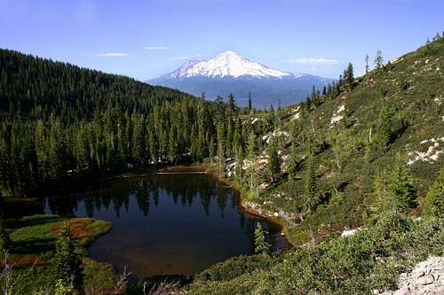 Mount Shasta beyond Little Castle Lake
The Mount Bradley ridge separates the watersheds of Little Castle Creek and Ney Springs Creek. Despite its name, Little Castle Creek is a sizable stream, though it tends to run low late in the season since it is fed from pockets of snow that cling to the northern cliffs of the Castle Crags. The source of Ney Springs Creek is Little Castle Lake, which lies at the beginning of the ridge. A sizeable resort was once located along the creek in the 19th century but foundations and stone catchments for the spring water are all that remain. Faery Falls, an attractive 40 foot cataract is located near the resort ruins. Another waterfall, Mossbrae Falls, is located at the foot of Mount Bradley in the Sacramento River Canyon.
The western half of the Mount Bradley ridge lies within the Castle Crags Wilderness. Beyond the wilderness boundary, the ridge passes through a patchwork of public and private land. The summit of Mount Bradley and the Forest Service lookout are located on Forest Service land that is entirely surrounded by private property. A road climbing out of the canyon from Dunsmuir reaches the tower. The Castle Lake Trail, the preferred route to the summit follows the length of the ridge and has easements where it passes through private property. Please respect property rights where appropriate.
Castle Crags Wilderness
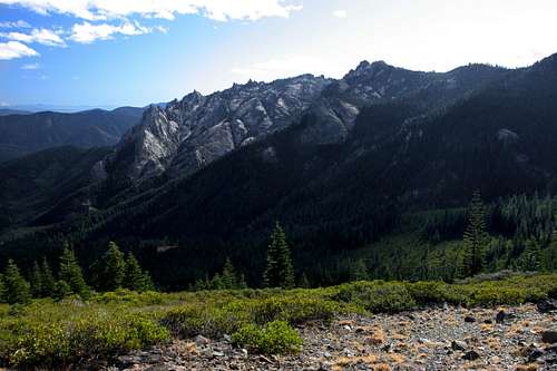
 The highpoint of the Castle Crags from Mount Bradley
Located in the Trinity Divide, the Castle Crags are a familiar sight to those traveling on Interstate 5. Rising suddenly out of the forested ridges lining the Sacramento River Canyon, the serrated granite spires of the Crags are an ominously enticing formation that beckons the intrepid to explore them. Most who do succumb to the Crags allure access them through Castle Crags State Park, which is located on the southeastern corner of the formation. The majority of those who do are unaware that very little of the Castle Crags actually lie in the state park. In truth, the bulk of the Crags are found in Shasta-Trinity National Forest’s Castle Crags Wilderness. Although small, with only 10,500 acres, the wilderness area packs an enormous amount of scenery into its small area.
The eastern half of the Castle Crags Wilderness is the home of the Castle Crags themselves. Further west, the mountains get much higher than the spires of the Crags, although they remain composed of granite with occasional intrusions of metamorphic rock. Here in the western half of the wilderness area is the cluster of high peaks around the Gray Rock Lakes basin. “Harry Watkins” is the tallest at 7,200, while “Gray Rock Dome” is only a little shorter at 7,070. Another lake basin is found between the Crags and the Gray Rock Lakes, however, the main lake in the basin, Castle Lake, lies just outside the wilderness boundary. Two smaller lakes, Little Castle Lake and Heart Lake, are found inside the wilderness boundary, high in cliffs above Castle Lake, near the base of the Mount Bradley ridge, which begins in the wilderness area but continues east, beyond the boundary.
The Pacific Crest Trail travels 14 miles through the Castle Crags Wilderness’ southern flanks.
Trinity Divide
 Mount Eddy and the Eddy Range from Mount Bradley
The Castle Crags Wilderness is the only wilderness area in the Trinity Divide. This region is the eastern most subrange of the Klamath Mountains. Sometimes called the Trinity Mountains, the range is not to be confused with the Trinity Alps, which lie directly to the west of the Divide and compose much of the views from the PCT as it travels along the crest of the Divide.. Two rivers, the Klamath and the Trinity, as well as their various tributaries dominate the Klamath Mountains. The Trinity Alps provide the bulk of the water that flows in the Trinity River. On the other hand, while the Trinity Divide does provide some water to the river it is even more important sense it forms the divide between the Trinity River’s watershed and watershed of the Sacramento River. The waters on the west side of the range ultimately find there way to the Pacific Ocean by way of the Klamath River while the waters on the east side reach the sea through the Sacramento River at San Francisco Bay. The Trinity Divide is topped by Mt. Eddy, the highest peak in the Klamath Mountains.
Getting There
From the town of Mt. Shasta, head west on W. Lake, crossing over I-5. At the stop sign, turn left onto Old Stage Road. After 0.25 miles, veer right onto WA Barr Road. Continue south, crossing over the dam that impounds the Sacramento River and forms Lake Siskiyou. Just past the dam, make a left hand turn onto Castle Lake Road which climbs for 7 miles to the roads end at Castle Lake.Red Tape
 The high peaks of the Castle Crags Wilderness
Part of the Mount Bradley ridge is in the Castle Crags Wilderness. Normal wilderness rules and ethics apply. These should also apply to those portions on private property. Be sure to respect private property.
A permit is required for campfires.
Shasta-Trinity National Forest
3644 Avtech Parkway
Redding, CA 96002
(530)226-2500
Mount Shasta Ranger Station
204 West Alma
Mt. Shasta, CA 96067
(530)926-4511
Camping
 The Castle Crags from Mount Bradley
There is an excellent little campground along Castle Lake Creek, a couple hundred yards from the trailhead. This campground is small and does not have water, though water can be accessed from the creek or the lake. Other dispersed camping spots are available along the road up to the lake. A large campground is nearby at Lake Siskiyou.