
|
|
Mountain/Rock |
|---|---|
|
|
49.18776°N / 19.03115°E |
|
|
5607 ft / 1709 m |
|
|
Overview
 Ridge in winter
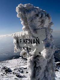 Snowwork :)
 Ridge in summer
In the Malá Fatra, the mountain is locally designated as Kriváň ("hooked peak"). We add "Fatranský Kriváň" to differenciate it from his much more famous homonym in the Tatras, Tatranský Kriváň (if we respect this regional differenciation prefix, however not often used for the latter).
The exact full name is Veľký Fatranský Kriváň, "Veľký" meaning "big", as there is a secondary top named Malý Kriváň just next to it. We can also abbreviate it "V.F. Kriváň" or VFK (no, no, not JFK). It is called Wielki Krywań in Polish, Nagy-Kriván in Hungarian and Große Krivan in German.
Curiously, Kriváň is the tallest mountain of the Malá Fatra, but far to get the most fame, for several reasons.
First, speaking pure beauty, it lies in the shaddow of the too magnificent neighbour Rozsutec, jagged and dolomitic as can be, while Kriváň is a round-shaped boring ridge.
Second, Kriváň has one of the worse possible tares for a mountain. It is served by a cable car (almost) to the top ! This will certainly recall to a Pole the unfamous crowds on top of Kasprowy Wierch...
Well, we will not say Kriváň is not the less "popular": for this reason it is the most, amongst tourists. But, from a mountaineer's point of view, unfortunately not, and partly due to this.
 Chleb and Veľký Kriváň from Steny
 Cable car to Snilovské sedlo
 At sunset
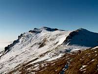 Chleb
Chleb Malý Kriváň
However, there are few good reasons to visit this Kriváň.
From the geologic point of view, it is the only top of the Malá Fatra to be of granite. It is the only representant of the horst that lifted the range, and consequently generated the neighbouring reliefs, made of sedimentary rocks and eroded by glaciers.
From the hiking point of view, the real hikers rarely walk only Kriváň. It is generally visited together with the other peaks on this ridge: Poludnovy Grún, Chleb, Stienky, and later on Pekelnik, and possibly Malý Kriváň.
Excepted in winter, when this is a rewarding trip, technically speaking there is no difficulty. But stunning views are provided all way long.
And, certainly, some people will certainly find compulsory to bag this high point, making Malá Fatra the fourth range in Slovakia behind the High and Low Tatras, and just few meters under Babia Hora (Diablak).
 Panorama from the mountain hut Chata pod Chlebom
Getting There
 Panorama from Chleb
 Mala Fatra in the skyline
 Chleb from the descent to Vrátna
 Snilovské Sedlo
Štefanová, Terchová, Kraľovany, or Martin are the usual trailheads. All is located in a handkerchief and the general driving instructions do not vary much whatever is the trailhead.
However one must be aware the whole area is very hilly and wherever we come from, the drive gets more and more convoluted as we get nearer the place.
Terchová is the only convenient town, close enough to the mountain, to be served with bus and trains.
By car, it varies according to the place we come from.
From Slovakia and coming from Bratislava, most is done via the motorway D1 until Žilina, where we take the 583 road till Terchová. In Terchová, drive to the Vrátna Dolina (topped by an aluminum Jánošík statue), and then Štefanová left when inside the valley.
 Panorama from from Krúpova hoľa
 Malý Kriváň
 Hromové
 Malý Kriváň
 Hromové
 Malý Kriváň
 Poludnovy Grún
 Malý Kriváň top
 On Chleb
Coming from Košice, the D1 via Poprad takes us to Ružomberok, and then it gets more complex. Take the road 18 Kraľovany, then 70 to Dolný Kubín, but turn before at Párnica via the 586 to Zázrivá and Terchová.
The vocation of the Slovak D1 motorway is to be fully continued in a medium-term future, and the planned route goes not far from Žilina, so it's likely that the acces to the Malá Fatra range will be much quicker.
The area is also close to Poland and several ways exist to reach it from this country. The luckiest ones are those who live in the Silesian region: despite often packed with cars, the drive through Bielsko-Biała, Żywiec and the border in Zwardoń is all straight. The 520 road is then reached either via Čadca or Oščadnica (smaller road). In Stará Bystrica, we take the tiny road which goes through Radôstka and Lutiše, passing a sceneric high pass before going down to the road 583 to Terchová.
We will meet important ongoing road works all along the Żywiec-Čadca area. The axis is meant to become a major road linking Poland and Slovakia, and the hilly region require a lot of equipments such as bridges and tunnels.
Those coming from Western Poland reach Čadca better by taking a short portion of Czech Republic in Těšín(Cieszyn), reached by leaving the A4 from Gliwice.
From Cracow and more East, we use the Zakopianka road that we follow until the Chyżne border. The road 59 leading SW, despite full of bends, takes us straight to Párnica, and then Terchová.
View Larger Map
 Views to Dolina Vrátna Views to Dolina Vrátna |
Routes
 On the trail, Velký Kriváň ahead
 On the way to the hut Chata na Grúni
 Velký Kriváň from Snilovské saddle
 Chleb
Chleb Velký Kriváň
 Poludnový Grún
 Hromové
- Loop from Dolina Vrátna
This is from far the most used route to walk the whole ridge, for the simple reason it goes like a half circle over the starting point, Chata Vrátna. Depending on everyone's form, or weather, or available time, it is possible to lengthen or shorten the walk as we want.
The ideal is to head first, via the yellow-marked trail, to Chata na Grúni, and then climb (steep !) to Poludnovy Grún (1450), beginning of the ridge walk.
The sligthly undulating ridge, but in average quite flat, takes us to Stienky and Chleb (1644), where we can observe prominent limestone outcrops, the last before the apparition of granite.
Just before Chleb is located a junction whose yellow and blue marked trails lead us to Chata pod Chlebom, where one can make a break or spend a night.
The pass Snilovské Sedlo is then reached either via the main ridge trail (red) or the hut diversion (green). The place is the arrival of the cable-car and for this reason usually crowded.
Velký Kriváň is reached by the red trail, and a small portion in cul-de-sac to the top. The top can be avoided on the north by a secondary trail going below (blue).
West from the top, we descend to Kepelnik (1609), where limestone progressively reappears, and then the pass Sedlo Bublen.
Some will choose to push the exploration to Malý Kriváň or even further, before returning.
The descent is made to Chrapaky (1417), and pass Sedlo za Kraviarskym, where a green-maked trail usually makes the descent back to Chata Vrátna through the forest.
Some can choose to make the whole loop longer by descending via Sedlo Prislop, further north, via the blue trail, to Stary Dvor, near the valley junction, and then elevating from this starting point to Chata na Grúni.
 On the trail, Chleb ahead
 Velký Kriváň
 Velký Kriváň
- Loop from the South
An alternative route is also possible from the opposite side of the range, South, but not used very often due to the length of the circuit, and the necessity to get back to the starting point by bus. Chata pod Chlebom is reached by the blue trail from Rieka, near the town Šútovo. After a visit to the top, we can return down either via the trail to pass Zajacová (green) and Hrabinka motorest (hotel on the main road), or via the hut Chata pod Kľačianskou Magurou and the town Turčianske Kľačany (bus).
Red Tape
 Before the storm
 Storm
Storm Storm
Storm Storm
Storm Beware of avalanches too...
Above all, let's mention that the main ridge of the Malá Fatra is particularly exposed in case of stormy weather.
Slopes are also particularly avalanchous in winter.
As for regulations, Malá Fatra is a national park with similar regulations than in the Tatras, and even more strict concenrning winter closure.
* Walkig offtrails is forbidden
* Wildcamping, bivouacking, fires strictly forbidden too. Consider also the high presence of bears. Having said that, there is a certain number of abandonned sherperd wooden huts known by locals, like this one, and using them overnight seems more or less tolerated, especially out of the high season.
* On the car parks of some trailheads, a little fee is collected (usually 1 or 2€)
* From November included to the 15th of June, all trails are closed in order for nature conservation, excepted for skitouring on the designated areas.
 Under the storm
Accomodation
 Chata na Grúni
 Upper station of cable car
 Terchová
 Chata na Grúni
 Chata Pod Chlebom
 Chata pod Kľačianskou Magurou
* Wild camping & bivouacking : As mentionned in Red Tape, forbidden AND dangerous
* Official campsites: Two campsite near Terchová, convenient to explore Rozsutec : Autocamping Nižné Kamence, also called "Camp Terchová", and Autocamping Varín.
On former maps, a campsite is indicated near the central junction of the Vratna valley. But this campsite stopped in 2002.
* Mountain huts: Two guarded huts : Chata pod Chlebom, as its names tells, under the peak Chleb on the south side. Another one under the peak Poludnovy Grún, on the north side : Chata na Grúni. Much further on the SW side: Chata pod Kľačianskou Magurou. Chata pod Rozsutcom, marked on some old maps south from Rozsutec, disappeared in 1985. On the foot of the mountain is also Chata Vrátna, so-called mountain hut, but accessible by the road, then rather a hotel than a hut. However an ideal base to start.
* Private accomodations: One will find a handful of hotels, pensions and private apartments in Terchová. Most of them are registered on the accomodation section of the Terchová town page. However, as mentionned before, Štefanová is the most pleasant place. Accomodations there are less easy to find on the web since many of them are small, do not have any web page, reacheable only by phone and not speaking many foreign languages. Those looking for quality standard can try for example this one. Otherwise, if coming out of the high season, it is reasonably possible to pop into the village without any reservation, ask people randomly (very nice btw) and find the dream place immediately.
On the opposite side of the mountain, Biela (sometimes called Biela-Zázrivá to differenciate it from other Biela's) is also a charming place with few accomodations, like Chata Mária & Penzión Fatra.
 Chata Vrátna