
-
 20652 Hits
-
 78.35% Score
-
 10 Votes
|
|
Mountain/Rock |
|---|---|
|
|
39.61971°N / 105.87323°W |
|
|
Scrambling |
|
|
Spring, Summer, Fall |
|
|
13204 ft / 4025 m |
|
|
Overview
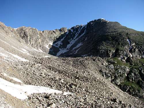
Thenthousands of people ski every year at A-Basin right below the ridge lines of Lenawee Mountain - but the mountain itself stays as lonesome as ever. The first half year of 2010 saw only seven entries into the summit registry. While you can see throngs of people on the summits of Grays and Torreys Peak from Lenawee Mountain, you will have the whole mountain to yourselves.
Lenawee Moutain is actually not really a single mountain, it is more long ridge line, with two highpoints and five side ridges fanning out to the south.
Lenawee Mountain is a far more diverse mountain than it might look from Loveland Pass - from there one sees only a scraggy ridge line with long scree filled gullies below. On the Chihuahua Gulch side however,Lenawee Mountain sports large alpine meadows (right along Lenawee Trail), cliffs, alpine lakes.
Getting There
Drive on I-70 to Dillon/Silverthorne, take exit 205 and travel east on Highway 6 toward Keystone. Just past Keystone turn right onto Montezuma Road (CR 5) just past Keystone Colorado. Continue along CR 5 for 4.62 miles to Peru Creek Road (FR 260) (if you hit the small town of Montezuma -turn around, you missed the turn off). FR 260 can be pretty bumpy at certain spots, but is makeable with a normal sedan if you take it slow.After 2 miles you will pass the trailhead for Lenawee Trail on your left - a small parking area for this trailhead is a couple more yards up the road to your right.
Another half or mile down FR 260 the rough 4 x 4 road up to Chihuahua Gulch is turning off to your left - a parking area is to your right.
Route

The only access from the North Side would be to trudge up the dusty service roads of A Basin to gain the ridge - what fun would that be. The only other alternatives would be scree filled gullies.
The access from Chihuahua Gulch is therefore a lot more attractive.
The numerous side ridges of Lenawee Mountain offer numerous alternatives for shorter or longer ridge scrambles. The longest option is the following:
Hike on Lenawee Trail (Trailhead on your left on 260 , 2 miles from Montezuma Road)until you are above treeline. Vast mountain meadows will start expanding to your right. Leave the trail and hike in direction of the ridge line to the right of you. Follow the ridge to the second highest highpoint on the ridge. On the other side of the bowl below is the highest point of Lenawee Ridge. The ridge connecting both highpoints can look intimidating - but there are no sheer cliffs on the north side of the ridge - difficulty never exceeds 2 +.
From the main summit you can either descend on a side ridge down to Chihuahua Gulch or keep on scrambling along the ridge in direction of Grizzly Peak (which is a bit more of a challenging climb).
At the valley bottom of Chihuahua Gulch a rough 4 x 4 road will get you back to F 260. You will have to cross a creek in between - coldness and force of the stream can be quite an obstacle at peak of spring run off.