Page Type Page Type: Mountain/Rock
Location Lat/Lon: 43.84753°N / 113.76223°W
Additional Information County: Custer
Activities Activities: Hiking, Mountaineering, Scrambling, Skiing
Seasons Season: Spring, Summer, Fall, Winter
Additional Information Elevation: 11224 ft / 3421 m
Sign the Climber's Log

Overview

Cabin Mountain from Lime MountainCabin Mountain from Lime
Cabin Mountain is the northernmost 11er of the White Knob Mountains in central Idaho. At 11,224 ft high it is also the 3rd highest peak in the range and the 74th highest peak in the state. The mountain is very long and has two summits which are nearly a mile apart. The southernmost summit is the highest.

It is often climbed in conjunction with the other 3 White Knob 11ers: Shelly, Redbird, and Lime Mountain. It is usually the last one of the four climbed and is also probably the most technically demanding.
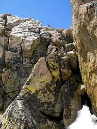
The Crux of Cabin MountainThe Crux
Depending on where the mountain is approached from it will be either a class 2 or 3 climb. The Northwest Ridge is the only true class 3 route, but because the actual summit is located on top of a large rocky tower there will be a little very easy class 3 climbing involved on the other routes as well.

The rock on Cabin Mountain is different than the rock on the other White Knob Mountains. It is reddish in color and there are places where solid rock can be found. The other peaks are basically large piles of crumbled rock and are lighter in color.

It is not known where Cabin Mountain gets its name. It does not look like a cabin and there are no cabins on it but it is a very fun climb in a beautiful area.

Getting There

Climbing the TowerClimbing the Summit Tower
Cabin s SummitCabin's Summit Tower
Access to this peak is basically the same as it is for Lime Mountain. Follow Highway 93 north from Arco until you reach the microscopic community of Darlington. Turn left on Smith road and follow it towards the hills to the west. Eventually it will turn to the north and become Dove Road. Anywhere the road splits always stick to the left (west). Just past a very remote ranch house it will finally turn into Alder Creek Road and will enter the Challis National Forest. From here on the road gets worse until it deteriorates into an ATV track leading to the 10,000 ft. summit at the head of Stewart Canyon. Go over Stewart Canyon pass and into the basin beyond. There you will see a large broad ridge to the west that leads directly up to the saddle between Cabin and Lime. This ridge is a very easy class 2 climb. Once you reach the saddle head north along Cabin Mountain's south ridge. There are two large rock towers farther up the ridge. The summit is located on the second tower.

Red Tape

View South from Cabin MountainView South
There are no permits or fees of any kind required to access this area. There are however many mine shafts to be aware of.
The White Knobs see a good deal of ATV use and there are many tracks in places they shouldn't be. Please tell the Lost River District of the Challis National Forest about this. Hopefully if enough people say something they will do something about it.

A 4WD with some clearance is recommended for accessing this area.

Weather


Camping

Cabin s North SummtCabin's North Summit
There are plenty of beautiful places to camp in the White Knobs although there are no established campgrounds. The eastern side of the range is much wetter than the western Copper Basin side. Streams and lakes are plentiful in Stewart Canyon and Corral Creek Basin below Cabin.

External Links

Splattski's Trip Report

Another trip report about Cabin and Lime

Idaho Outdoors Forum
The Pioneers from Cabin MountainThe Pioneers from Cabin