
-
 18594 Hits
-
 86.59% Score
-
 23 Votes
|
|
Mountain/Rock |
|---|---|
|
|
40.60695°N / 108.87013°W |
|
|
Moffat |
|
|
Hiking |
|
|
9005 ft / 2745 m |
|
|
Overview
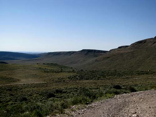
Stuck in the remote Northwest corner of Colorado, Zenobia Peak has a few claims to fame. First off, it is the highest point of Dinosaur National Monument. Zenobia is also one of Colorado's many 2,000 ft prominence peaks. The summit is manned by a fire tower; as far as I know it is still active in the summer months. As a result, a 4WD road goes all the way to the top, though the last part of the road is gated (those in passenger cars would be looking at a long road walk of almost 20 miles round trip).Update: While I had no problems accessing the peak back in August 2010, I have been informed that the property owner along Douglas Mtn Road has closed off access since then. Please respect all Private Property and either bypass or seek permission before proceeding.
Also, due to classification of the land as wilderness the National Park Service is closing off the last few miles of the road from vehicles belonging to the general public. Foot traffic is still allowed, assuming one can bypass the Private Property from the eastern approach.

|

|

|
|---|
|
|---|
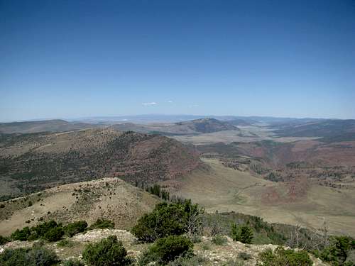
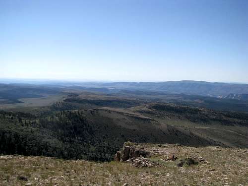
Views abound from the top of Zenobia. To the south are the sheer canyons of Dinosaur NM. West rise higher and higher the circlish mounds of the Uintas. North are the long ridges of Diamond Peak, a formidable obstacle between you and the Wyoming border behind it. Along the eastward horizon stretches the Sierra Madres, the Elkheads, and the Flat Tops going the north to south. All around is the yellowish desert landscape of NW Colorado, populated here and there by some sparser evergreen forests, akin almost to a Coloradan Serengeti. Unless the ranger living at the lookout is around you're likely to have the entire summit to yourself, after a long and lonely drive through the backroads.
|
|---|

|

|

|
|---|
|
|---|
Red Tape
Update: The last few miles of CR-116/Douglas Mtn Road crosses private property. Please see above for more information.Getting There
Zenobia Peak is best accessed via CO-318. From Maybell drive past the town of Sunbeam for 2.8 miles and take a left onto CR-10. Follow CR-10 for 27 miles, where it junctions with CR-60. Take a left onto CR-60.
CR-10 is all gravel, passable for passenger cars, though there is one section with steeper grades. Another way to get here from the east is to take CR-12 further on down CO-318. This reduces miles travelled on dirt roads. Follow CR-12 SW for 6 miles where it ends on CR-10. Take a left onto CR-10, pass the “town” of Greystone (just a few houses, really), and proceed straight onto CR-116 when CR-10 veers left, or follow CR-10 left and take a right onto CR-60 in a mile or so.
If you do have time though, take CR-10 from its eastern junction; it is a very pleasant drive, especially in the morning:

|

|

|

|
|---|
|
|---|
CR-10 junctions with CO-318 twice, here, and about 25-30 miles west down the road. If coming from the Utah side you can take CR-10 from the western junction. Follow CR-10 south until junction with CR-12, then follow above directions.
Here either the map or the road is mislabeled. Several maps (including Google, and the DeLorme Atlases) show CR-60 going all the way to the top of Zenobia. If you assume this it will get a little confusing.
Follow CR-60 off CR-10. Stay straight at the first intersection and BLM sign. 1.8 miles from CR-10 there is another intersection and BLM sign. Straight is CR-60, and bearing right is CR-116, according to the sign. However, the map might tell you the exact opposite. In that case, ignore your map and take the right; the road labeled CR-116 (actual signage) is the one that will take you to Zenobia. Later on there are also signs labelling the road “Douglas Mtn Road”:
 Take Right Here Take Right Here |
|---|
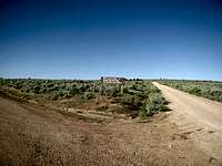
Follow Douglas Mtn Rd through shaded evergreens. From the CR-60/116 junction passenger cars can proceed only another 2 or 3 miles, past the Whiskey Springs Ranch. The road gets pretty rough from here on out. It’d be a long walk from here for those with passenger cars, as you are still 9-10 miles from the summit, with 1500 ft net (not gross, and the road does go up and down a little bit) elevation gain to go.
There are some views further on the road, to the right (north), and Zenobia and the obvious fire tower will occasionally pop into view. Pass through a gate saying end of County Road. 6.7 miles from the 60/116 intersection bear right and pass through another gate, telling you you’re “Leaving Public Lands” and indicating further ahead is Private Property.
 1st Gate 1st Gate |
 2nd Gate 2nd Gate |
|---|
2.7 miles from this gate you approach another gate (3rd). The gate was unlocked when I was there. Do NOT drive through this gate; it dead ends at a private residence.
 Take left BEFORE this Gate Take left BEFORE this Gate |
|---|
Instead, take a left before the 3rd gate (there are a couple places where you can do so). You can drive for another few minutes to another gate, number 4, this one with barbed wire. I parked here, hopped the gate, and walked the rest of the way to the summit. If you are not dumb enough to lose the road (I was, and turned what should have been a road walk into a class 2 bushwhack), it’s around 2 miles give or take a bit to the top, with about 1200 ft of elevation gain. Bear right at the only intersection on this last stretch of the road.
 Bear Right Here Bear Right Here |
|---|
The fire tower on the summit might or might not be occupied. If you walk up the tower a sign tells you to yell or throw pebbles so the ranger knows you’re coming.

|

|

|
|---|
Lodging
There are Campgrounds at Dinosaur National Monument. The only one in the Zenobia Area is the Gates of Lodore Campground, further west off the county roads from CO-318 near the Utah border. Note the rest of Dinosaur National Monument is several hours away.Primitive Campgrounds are also available at Browns Park NWR, north of the Gates of Lodore
The town of Sunbeam did not seem to have any services as of August 2010, but there were a few Motels in Maybell, about 7 or 8 miles east from the first CR-10 junction. 30 miles east down the road from Maybell is Craig, with all the services you would need.
When to Climb
Late Spring through Early Fall. Much of the county roads in this area are not maintained in the winter.External Links
Dinosaur National MonumentA useful TR I found online
Recent Article about the Zenobia Fire Lookout