
-
 9929 Hits
-
 86.85% Score
-
 23 Votes
|
|
Mountain/Rock |
|---|---|
|
|
37.82701°N / 119.36062°W |
|
|
Tuolumne |
|
|
Hiking, Scrambling |
|
|
Spring, Summer, Fall |
|
|
11105 ft / 3385 m |
|
|
Overview
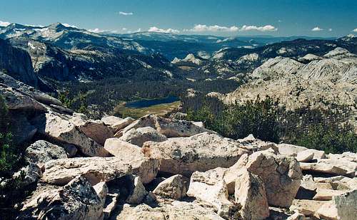
Southwest from Reymann Peak
From the summit one enjoys unobstructed views southwest over the Echo Creek and Cathedral Fork drainages out towards Little Yosemite Valley and the Clark Range. There is an impressive view of the north face of Peak 11,357' to the south as well as the east face of the Matthes Crest to the west. To the north over Tuolumne Meadows the Sierra stretches in the distance as far as the peaks around Sonora Pass.
Over Lyell Canyon from the northeast to the southeast the Sierra crest runs from Mt. Dana to Mt. Lyell.
Getting There

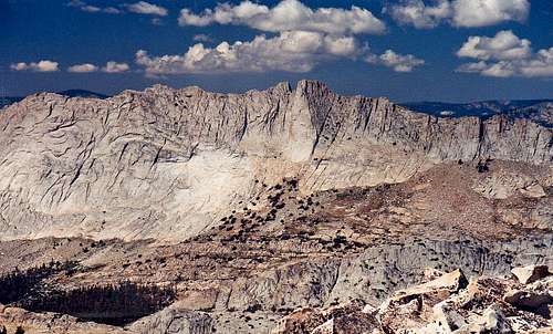
North face of Peak 11,357' from Reymann Peak
East auto approach: From the junction of Hwy. 395 go west 12 miles (or 7 miles from Tioga Pass) and turn left on the campground road.
Go .1 mile and take a right. Go .25 mile to the 2nd left. Go .22 mile to the Elizabeth Lake trailhead at the roads end cul-de-sac (8,700'). Take the forested Elizabeth Lake Trail 2 1/4 miles south up to the meadow by Elizabeth Lake (9,487'). Break trail and hike 1.1 miles south up to the saddle just west of Reymann Peak. Follow the west ridge .4 mile east to the summit.
The north slope can also be scrambled directly up south-southeast from the meadow by Elizabeth Lake.
This peak can be combined with Johnson Peak which requires following the east ridge down from the summit along a reversed L shaped route to an open saddle and north up the south ridge of Johnson Peak to the summit at 1.15 miles.
The south slope looks to be a class 2 scramble 1/2 mile straight up from Reymann Lake.
Red Tape

Southeast from Reymann Peak
Camping
Matthes Crest east face from Reymann Peak
There are also campgrounds just north of Tioga Pass outside the park boundaries by Tioga Lake (9,660'), up the road to Saddlebag Lake (10,000') and further along Hwy. 120 to Ellery Lake (9,500').
For info on other campgrounds along Hwy. 120 and camping in Yosemite National Park click here.
Current Yosemite National Park weather and 5 day forecast

Northwest from Reymann Peak with Elizabeth Lake below
Etymology
Reymann Lake Tuolumne Meadows 15'Named for William M. Reymann (1883-1938), A Yosemite National Park ranger. (Bingaman, Guardians,115.) (YNP)
Place Names of the Sierra Nevada - Peter Browning