
-
 20054 Hits
-
 77.48% Score
-
 8 Votes
|
|
Mountain/Rock |
|---|---|
|
|
54.37126°N / 3.13668°W |
|
|
Cumbria |
|
|
Hiking, Mountaineering, Trad Climbing, Scrambling |
|
|
Spring, Summer, Fall, Winter |
|
|
2555 ft / 779 m |
|
|
Overview
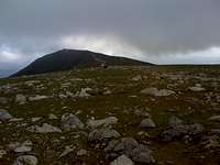
Lying to the west of Coniston Old Man, Dow Crag is hidden from sight by it's taller neighbour, from the popular village of Coniston. Goats Water separates Dow Crag from The Old Man Of Coniston. The east face of Dow Crag makes it a popular destination for climbers in the Lake District with grades ranging from Moderate through to E6 (UK grades). There is also plenty of opportunity for scrambling around Dow Crag's 5 buttresses, named Buttress A to E, and gullies.On a clear day Dow Crag's rocky summit will offer views of Coniston Old Man over Goats Water, the Scafells, Harter Fell and the Cumbrian coast line.
Getting There
There are 3 main starting points for an ascent of Dow Crag.Coniston
To get to Coniston, the best approach is to go via Ambleside. From the south, leave the M6 at junction 36 and follow the A590 then A591 to Windermere and then through to Ambleside. From the North, leave the M6 at Junction 40 and take the A66 towards Keswick, turning south just before Keswick onto the A591 heading towards Windermere.
From Ambleside follow the signs to Coniston on the A593 which leads directly into Coniston.
Torver
Torver can be easily gained once at Coniston by following the A593 out of Coniston heading south. Alternatively, Torver can be gained from the south by taking the Junction 36 turn off on the M6 and following the A590 (signs to Barrow in Furness) and staying on the A590 until Greenodd, taking the A5092 right turn, sign posted Broughton In Furness. Stay on the A5092 until another right turn, sign posted Coniston, for the A5084. This will take you along the South West shores of Lake Coniston to the Junction of the A593, which is where Torver is situated.
Duddon Valley - Seathwaite
The Duddon Valley can be accessed by leaving the M6 at Junction 36 and following the A590, heading towards Barrow In Furness. Follow the A590 until Greenodd and take the right turning A5092, sign posted Broughton In Furness. Stay on the A5092 until another right turn for Ulpha, past Broughton In Furness, just before a set of traffic lights. Follow the signs for Ulpha and then for Seathwaite.
Hiking
From ConistonDow Crag can be accessed from Coniston by taking in The Old Man of Coniston first. Head West out of the village of Coniston up a steep road (Old Furness Road) leading to Walna Scar Car Park. From the Walna Scar Car Park the Old Man can be ascended via the slate mine track heading initially North and then West. Once Coniston Old man has been summited follow the track North West, circumventing Goats Water to a depression called Goats Hause. Head south up the slopes to the rocky summit of Dow Crag.
 Dow Crag from Coniston Old Man
Alternatively, Coniston Old Man can be missed out by following the Walna Scar road West-South West from the Walna Scar car park. Once Coniston Old Man has been circumvented, you can either break off from the Walna Scar road and head North to Goats Water and ascend directly to Goats Hause and turn back South to the summit of Dow Crag, or continue on the Walna Scar road further until you reach the south ridge of Dow Crag and ascend from the South taking in subsidiary peaks Brown Pike and Buck Pike along the way.
 Dow Crag above Goats Hause
From Torver
The quickest way to Dow Crag is to access it from Torver. Follow the roads through the back of the little village picking up the footpath sign posted Walna Scar. From here, a well maintained path will take you through Tranearth Farm and up to the Walna Scar road. When you reach the Walna Scar road (it's more of a gravel track than road), turn left and shortly you will come across the right hand turn leading to Goats Water, or continue along the Walna Scar road to the bottom of the South Ridge of Dow Crag.
From the Duddon Valley - Seathwaite
An approach from the Duddon valley could be considered approaching Dow Crag from the back. Head East from the village of Seathwaite along the Walna Scar Road. When you reach the foot of the South Ridge, head North, taking in the subsidiary peaks of Brown Pike & Buck Pike along the way. Alternatively, head North West from Seathwaite to a reservoir called Seathwaite Tarn. Walk alongside and past the reservoir on the East side until you come across a path heading directly up the slope (and South) next to Far Gill. This leads to Goats Hause from the North, the direct opposite side from Goats Water. From Goats Hause, head south and upwards to the rocky summit of Dow Crag.
Scrambling
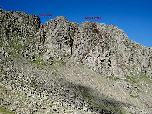
Easy Gully - grade 3
Easy Gully is a short gully to the left of A Buttress. A chock stone guards the lower section. A helmet is advisable in this gully as there are a lot of loose stones. There are 2 sections of the gully which will test your scrambling skills, a rope is advisable should any aid be needed, and it may also be useful should a retreat be necessary. At the first difficult section a left hand alternative branch is available, of a grade 2 rating.
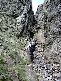 The start of Easy Gully
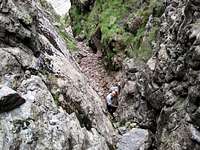 The first difficult section in Easy Gully
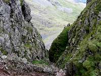 Looking down Easy Gully
Easy Terrace - grade 3
Easy Terrace is a descent route used by climbers on the lower section of B Buttress. Beyond the terrace, the route continues up the upper section of B Buttress, zig zagging a route of easiest access up the crag. Although not as technically difficult as some sections of Easy Gully, Easy Terrace is at times very exposed and will test your head for heights.
 The start of Easy Terrace
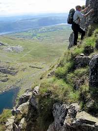 The upper section of B Buttress
Climbing
There are many climbing routes on Dow Crag, a famous Diff being Giants Crawl.Please add climbing routes you've done on Dow Crag to this section.
Reference
MapsOS Map OL6 1:25,000 scale.
Guide Books
A Wainwright - Book Four - The Southern Fells
visentin - Sep 7, 2010 3:41 am - Voted 10/10
perhaps a routerather than a top ?
AndyWhaley - Sep 7, 2010 5:05 am - Hasn't voted
Re: perhaps a routeI wouldn't describe Dow Crag as being a route on another mountain, I believe it to be a mountain in its own right. I can now see that a page has been posted describing Dow Crag as a route, but I don't agree with this. Dow Crag is a mountain that has it's own routes i.e. Easy Gully, Easy Terrace, Giants Crawl and many more. It's prominence from Goats hause is almost 100m and it is at least a 2km hike to its neighbour Coniston Old Man. Therefore it has a look and feel of a separate mountain.