
-
 18195 Hits
-
 81.84% Score
-
 14 Votes
|
|
Mountain/Rock |
|---|---|
|
|
41.13122°N / 122.44855°W |
|
|
Trinity/Shasta |
|
|
Hiking, Scrambling |
|
|
Summer, Fall |
|
|
7268 ft / 2215 m |
|
|
Overview
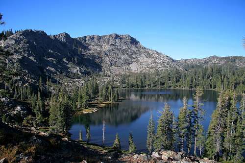
 The summit of the Grey Rocks from Cerulean Lake
Northern California is teeming with anonymous and unappreciated mountains. Although nearby Mount Shasta may famously be as lone as God, no great peak in the region is as forsaken and lonely as the Grey Rocks. Towering prominently above the surrounding landscape, their dark, brooding mass is glimpsed for a tantalizingly brief moment when traveling south on Interstate 5 from Mount Shasta. Aside from this abrupt vista, the Grey Rocks are only observed from parts of the Castle Creek drainage, from high in the Trinity Divide or the Trinity Alps, or from the slopes of Mount Shasta. The difficulty in observing the Grey Rocks is only surpassed by the challenge of accessing them. No trails lead into the massive complex of peaks and the only roads in the area are generally poor and seldom used. Access is further complicated by the presence of immense brush fields that block off the most obvious approach routes to all but the most self-punishingly motivated. What these impediments have obscured is one of the most breathtaking mountain landscapes in the California Northstate. All the ingredients of an outstanding alpine experience are present: high, jagged, rocky peaks, numerous gorgeous glacial lakes with exceptional fishing, lush meadows and incredible vistas.
The Grey Rocks are a cluster of peaks composed of dark, metamorphic rock. Exceeding 7,000 feet, they are among the tallest peaks in the region. There are two primary summits. The north peak is the highest at 7,268 feet. The southern summit is only slightly shorter at 7,174 feet. There is another prominent point that is 7,070 feet but it is subordinate to the northern summit. For unexplained reasons, the USGS maps list two named benchmarks on the southern peak. The higher of the two, marked “Whalan” is 45 feet higher than the adjacent “Mears” benchmark. Why two points would be so close is unclear. The peaks are on the crest of the Trinity Divide, which marks the division between the watersheds of the Sacramento River and the Trinity River.
 Mount Shasta, the Castle Crags and Grey Rocks Lake
Like many other peaks in the region, the Grey Rocks exhibit a stark contrast between their northern and southern sides. On the southern slope, the rock is dark and weathered. The peaks look more black than gray. At the higher elevations the trees give way to vast swaths of brush. All of the usual suspects are present: manzanita, chinquapin and huckleberry oak. On the northern side, the rock reveals its namesake gray hue. The stands of timber reach much higher and the brush is significantly thinner, allowing for much easier travel. Evidence of glaciation on the Grey Rocks is apparent. There are two large cirques hosting a trio of small lakes nestled into the rocky crags. None of these lakes are named. Three large lakes, Tamarack Lake and the Twin Lakes, are found immediately to the south of the Grey Rocks. A fourth body of water, solitary Grey Rock Lake, is cradled in a large basin at the eastern foot of the formation.
 Grey Rock Lake and the canyon below the south summit of the Grey Rocks
The best places to appreciate the scenic qualities of the Grey Rocks are in the two glacial cirques. Here one finds the high peaks of the Grey Rocks towering 1,000 feet directly above the small pools. The landscape around the lakes is exceptionally rocky. This is easily the most rugged terrain in the Mount Shasta region other than Mount Shasta itself and the nearby Castle Crags. All three lakes are unnamed but for the purposes of identification on Summitpost, they have all been christened. The two lakes below the south summit have been designated Whalan Lake and Mears Lake, corresponding to the higher and lower benchmarks high above. The lake below the north summit is named Cerulean Lake, after its beautiful color. A map showing the locations of these lakes is found here.
The other lakes around the Grey Rocks also offer excellent opportunities for hiking, fishing and camping. Grey Rock Lake is legendary amongst the most knowledgeable of Siskiyou County anglers for its superlative fishing. The journey in to the lake is one of the finest hikes in the region. The views of Mount Shasta and the Castle Crags from the rim above the lake are some of the best to be had. The trio of lakes on the south side of the Grey Rocks, Tamarack Lake and the Twin Lakes are also magnificent bodies of water. Tamarack Lake in particular is one of the prettiest lakes in northern California, highlighted by a dramatic cliff towering 700 feet above the lake.
 Tamarack Lake, just south of the Grey Rocks
It is astonishing that an area of such scenic quality has gone almost completely unnoticed and offers a truly wild and secluded experience. Most of the use in the area comes from seasonal hunters and a handful of fishermen. A few hikers visit the Tamarack Lake area, fewer still make the trip to Grey Rock Lake. Cerulean, Whalan and Mears Lakes are unknown to longtime Shasta residents and even Forest Service personnel were unaware of their existence.
Some discussion regarding the name “Grey Rocks” is in order. Typical of appellations in the Klamath Mountains, there are numerous objects identified with the same name (the worst case of this occurs in the Trinity Alps where there are no less than nine lakes in three separate areas containing the word “boulder”, as well as three peaks sharing the name Boulder Peak in the Klamath Mountains). The same holds true for the Grey Rocks. There are three distinct areas in relatively close proximity that bear that name. The first is a group of lakes along the South Fork of the Sacramento River, six miles north of the Grey Rocks. The lakes are called the Gray Rock Lakes, but are spelled in the American fashion, rather than the English form labeling the subject of this page. An unnamed peak above the Gray Rock Lakes is dubbed “Gray Rock Dome”. As noted previously, in addition to the Grey Rocks themselves, a lake found on their eastern flank is named Grey Rock Lake, adding to the confusion. Lastly, south of the Grey Rocks, along the Pit arm of Shasta Lake is found the North and South Gray Rocks. These peaks are prominently visible from I-5. South Gray Rock is the limestone peak high above Mountain Gate that has a quarry on its slopes. North Gray Rock across Shasta Lake from its sibling is the massive gray limestone mountain that dominates the view as one crosses the Pit River Bridge. This peak contains the Shasta Caverns. It is possible that the repetition of the name has contributed to the Grey Rocks anonymity.
 The Grey Rocks from "South Mumbo Peak"
A map showing the different Grey/Gray Rocks in the area is found here.
The Trinity Divide
 South Summit from Grey Rocks North
The Grey Rocks are one of the more prominent summits in the Trinity Divide. This region is the eastern most subrange of the Klamath Mountains. Sometimes called the Trinity Mountains, the Divide is not to be confused with the Trinity Alps, which lie directly to the west of the Divide Two rivers, the Klamath and the Trinity, as well as their various tributaries dominate the Klamath Mountains. The Trinity Alps provide the bulk of the water that flows in the Trinity River. On the other hand, while the Trinity Divide does provide some water to the river it is even more important sense it forms the divide between the Trinity River’s watershed and watershed of the Sacramento River. The waters on the west side of the range ultimately find there way to the Pacific Ocean by way of the Klamath River while the waters on the east side reach the sea through the Sacramento River at San Francisco Bay. The Trinity Divide is topped by Mt. Eddy, the highest peak in the Klamath Mountains.
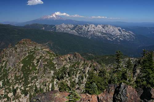 Mount Shasta and the Castle Crags from the Grey Rocks
The Trinity Divide has three primary sections. The northernmost is the Eddy Range, stretching south from China Mountain to “Porcupine Peak” and dominated by massive Mount Eddy. South of the Eddies is a long east-west spine of mountains beginning at the Castle Crags and moving west to Gumboot Saddle. This is the most heavily used section of the Trinity Divide due to its ease of access from Mount Shasta. South of Gumboot Saddle, the Grey Rocks burst out of the forest ridges and mark the beginning of the southernmost reaches of the Trinity Divide. From the Grey Rocks, the crest travels southwesterly, reaching its final heights at 6,805 foot Red Mountain. Between the Grey Rocks and Red Mountain there are 8 named lakes and nearly a dozen unnamed small lakes. Beyond this point as one travels south, no peaks reach the 6,000 foot level and there are no more lakes.
Grey Rocks Area Map
 The Grey Rocks
Route Information
There are several possible routes to the summit of the Grey Rocks. The route that passes by Cerulean Ridge is the most direct and scenic. Information on it can be found here.Getting There
 Mount Shasta from the Grey Rocks
From Mount Shasta, travel south on Interstate 5 and take the Castella exit. Turn right onto Castle Creek Road. After climbing 3,500 feet in 11.5 miles, you will reach at Whalan Summit. Pass the road on the right leading to the Pine-gri-la resort. About 0.3 miles past this point, make the first left on an unmarked but decent road. Once having turned, stay to the right and enter a large quarry area, which was once the site of old Whalan Station, where tolls were once collected on the road between the Sacramento and Trinity River Canyons. Continue on this road for another mile, staying to left and always following what seems like the main route. The road quality will continually degrade and low clearance vehicles may need to park and walk from wherever one is uncomfortable proceeding. Eventually, the road enters a large clearing where there are numerous large logs piled up. The road continues from here, but its quality is such that proceeding further is unadvised. Park in the clearing.
Camping
 The Grey Rocks from Tamarack Lake
The nearest campground is at Castle Crags State Park, 11.5 miles from Whalan Summit. There is excellent dispersed camping along Castle Creek Road, much of it along Castle Creek itself. Perhaps the best place to camp in the area is at Tamarack Lake, on the south side of the Grey Rocks. No campground facilities exist but it is a gorgeous location and a road leads all the way to the lake. The nearest Forest Service campgrounds are at McBride Springs on Mount Shasta, at Castle Lake, Gumboot Lake, and at Lake Siskiyou, though these are all rather far away.
Red Tape
 Cerulean Lake
The Grey Rocks are split between Shasta-Trinity National Forest and private property. Moreover, much of the route leading to the south summit is privately owned. It seems the property owners have not attempted to regulate travel across their land. Nonetheless, tread carefully while at Cerulean Lake and climbing towards the summit.
A permit is required for campfires in the national forest.
Shasta-Trinity National Forest
3644 Avtech Parkway
Redding, CA 96002
(530)226-2500
Mount Shasta Ranger Station
204 West Alma
Mt. Shasta, CA 96067
(530)926-4511