
|
|
Mountain/Rock |
|---|---|
|
|
43.15604°N / 122.04789°W |
|
|
Douglas |
|
|
Hiking, Mountaineering, Scrambling, Skiing |
|
|
Spring, Summer, Fall, Winter |
|
|
8178 ft / 2493 m |
|
|
Overview
Mimicking its Cascade neighbor to the north, Howlock Mountain, the unofficially named East Peak tranquilly rests under the gaze and shadow of its brothers looming face.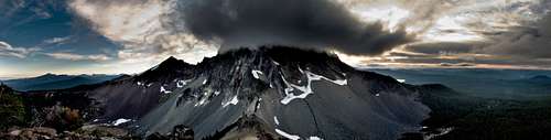 Thielsen's East and North faces as seen from midway up East Peak on Hollys Ridge.
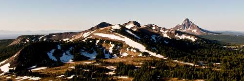
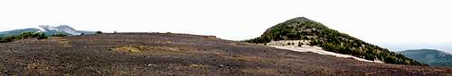 East Peak rising slightly higher above the saddle between its two summits.
Situated approximately a mile off the beaten path of an already scarcely populated region East Peak doesn't receive a lot of attention, but offers much for those seeking serenely breathtaking and seldom viewed perspectives of Mount Thielsen's impressive overhanging north/east faces. The geographical association to Howlock Mountain, albeit less dramatic, comes from its two summits and the saddle between them, although the geological features of East Peak more closely resemble Mount Bailey, and at 8,178 feet it is slightly smaller than either of the other two. However, the peak still comes in at number 74 on Jeff Howbert's list of Oregon's 100 Highest Peaks.
For those who love to tackle lists, like myself, this will definitely prompt you to head out this way, but for the many who aren't hellbent on such things the reward for climbing East Peak is still greatest in the experience alone.
Getting There
The standard and easiest access to East Peak is from the Howlock Mountain Trail off Highway 138 beginning at Diamond Lake's northernmost end. See the Thielsen Creek Trail route page for more information.An additional access point is located to the south off Highway 138, two miles east of its junction with Crater Lake's northern access road, at the Pacific Crest Trail. This route should take you up the south ridge of Mount Thielsen, but you'll want to eventually drop down to the eastern meadow below before climbing up East Peak. "I climbed Thielsen East from the south. I hiked the PCT for a ways and then left the PCT and climbed Thielsen South (point 8457). From there I found a way down into the bowl on the east side of Thielsen and then up to the East peak 8178. There was nothing technical about my route, but it was in the summer with no snow." - Dennis Poulin
Alternatively you could take the long, but scenic, approach to the north along Tipsoo Peak Trail/Forest Trail 1472 from NFD 4793 (to Cinnamon Butte) that forks onto NFD 100. You may want to plan for an overnight stay as hiking cross country along the Sawtooth Ridge will likely slow anyone's pace considerably and adds several miles to the overall trip; conversely you could pick up along the PCT just below Tipsoo Peak. This will take you beneath the Sawtooth Ridge/Howlock Mountain until you reach the same junction at Thielsen Creek as you would if approaching from the standard Diamond Lake access point to the west. Read my TR of Howlock Mountain to learn more about the Sawtooth Ridge: The Holly Sawtooth.
 The Sawtooth Ridge from Tipsoo Peak with East Peak hidden behind Howlock Mountain.
 Seemingly easy, but unexplored, remainder of Sawtooth Ridge from Howlock Mountain.
Note that I have not climbed either of the last two routes in their entirety and that one should plan for cross country travel accordingly.
Camping
For camping at Diamond Lake see 2Skinners Mount Thielsen Page.Thielsen Camp located beneath Mount Thielsen's North Face offers a good base and Thielsen Creek is a good water source if you wanted to span out your time in the surrounding area, but this requires hiking several miles with the necessary gear and provisions.
Lastly the meadow to the south of East peak would provide a truly solitary camp with Cottonwood Creek as a potential source for water.
Red Tape
A Northwest Forest Pass is required for parking at the Howlock Mountain Trail and they do enforce it. I had an annual pass and didn't look elsewhere for a self-serve day pass box. However, I know you can definitely acquire day passes a couple miles down Hwy 138 at the Thielsen Trail Head.Sno-Park Permits are also required from November-April.

When To Climb
Because East Peak's primary access point is from the Howlock Trail, which happens to also be a popular nordic ski trail, you could really access this peak year round without difficulty.External Links
Trails Galore - Thielsen Creek TrailSkiing the Cascade Volcanoes
Umpqua National Forest
Mt. Thielsen- McLoughlin Memorial(North Face)