
-
 21488 Hits
-
 83.69% Score
-
 17 Votes
|
|
Mountain/Rock |
|---|---|
|
|
39.16401°N / 105.33039°W |
|
|
Jefferson |
|
|
Hiking, Mountaineering, Trad Climbing, Sport Climbing |
|
|
Spring, Summer, Fall, Winter |
|
|
8877 ft / 2706 m |
|
|
Overview
Let me begin by stating that this page isn't so you can blindly read my description and walk up this mountain. This page is meant to inspire you to go have an adventure. This mountain is a special place, famed for decades by rock climbing pioneers, and it belittles the mountain to take away all of the adventure by "over-paging" it. This is a guide to get to the mountain, and to pick a route to get to the top. Sheeprock is a grand adventure, so go enjoy it!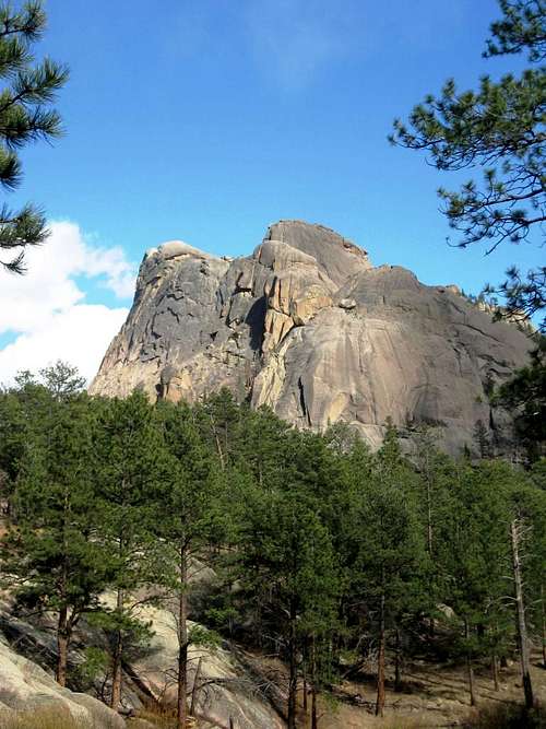
Amazing rock.
Sheeprock
Elevation : 8,877'
CO Peaks Rank : 3008th highest ranked peak
Counties : Jefferson
Quad : Cheesman Lake
Coords : 39.1896°N, 105.3304°W
Rise : 977'
Stats courtesy of ListsofJohn.com
Sheeprock, 8,877', is the dominating feature of the Cheesman Reservoir area. Due to its prominence of almost 1,000', it was likely the main show before the Hayman fire devastated the area, but since the fire, it sticks up and declares its presence boldly. It stands tall above the surrounding peaks, all fine climbs themselves. Peaks like The Turret and Big Rock Candy Mountain just across the river in Douglas County, and peaks on the west side of the South Platte River like Sunshine Dome, South Sheeprock, Cheesman Overlook, and Tick Dome.
It is interesting to note that of these peaks, most of them require technical ascents for their easiest route up (Tick Dome @ 5.7, Big Rock Candy Mountain @ 5.9, The Turret @ 5.8, Sheeprock @ 5.5, South Sheeprock @ 5.5). What that means is that unless you are very comfortable soloing difficult and often times decomposing Pikes Peak Granite and have some sort of ability to levitate down, you will need a rope and know how to use it and the associated gear to ascend them and get down safely.
While there are many routes to finally get you to the top of Sheeprock, they all require a decent hike to even get you to the base, somewhere north of 4 miles RT and more than 1500' of gain. You can, of course, just go to the viewpoint and see the formation, for by itself, it is a fine outing.
Getting There
From Denver:Take Highway 285 South to Pine Junction, about 25 miles distant from the 285/C470 interchange. Head south on 126 about 22 miles, and turn right (west) at the Cheesman Trailhead. This turns into a dirt road, FS 211. Take this west and south 7 miles, keeping right at a 3-way intersection about 2 miles in (that way goes to Cheesman Reservoir). There is a strange collection of signage and mailboxes here. The road is generally passable for 2WD vehicles, but often suffers from washboard later in the season. There are only a few options for parking (you must park only in designated P areas), and thankfully, one of them is the former site of the Molly Gulch Campground, closed since the fire. It is on the east side of the road. There is room for about 10 vehicles here.
The Hike:
From the parking area, descend down to Goose Creek. You have options here. Find something to cross on, or find a shallow and remove your footwear and cross.

Beaver dam, or wading?

Note the people to the right of the base.
After this, the trail cuts sharply right, and continues southerly. Eventually you will come to a 3-way intersection, with one trail cutting back NE and the main trail continuing south. The NE trail goes over to some really big and significantly harder climbs, which are not covered on this page. Continue on south, and you will meet up with the social trails the Ranch has installed, as well as find some signage. Here, you turn left (east), and head up into the boulders. The trail continues on, occasionally marked with small plastic signs with black arrows, other times with spray painted arrows (presumably from the Ranch). Some 3rd/low 4th class scrambling

Tree Solo!
is required to get through the boulder piles, which will eventually put you on the observation ledge:

Holy Cow! We're climbing that!?!
Red Tape and other things to worry about:
Red Tape:
One should always exercise extreme caution with fire/campfires/smoking in the area. Quite often, there is a full outright fire ban in Jefferson County. If you need any evidence of the devastation a fire can cause, look around while visiting Sheeprock. The fire here was so hot, it even destroyed the rocks.
There is also Private Property (Lost Valley Ranch) abutting the National Forest land that Sheeprock sits on. While they are generally a friendly bunch, please respect their land and boundaries. The routes to and from all of Sheeprock's climbs and peaks can be done from the National Forest. Additionally, the folks at the ranch also do horse trips, and the trails are definitely singletrack. They also do target practice and shooting on their property, so your safety is best preserved by staying in the N.F.
Otherwise, no red tape exists.
Other things to worry about:
I recommend wearing long pants for a few reasons: raspberries, goosberries, wild roses, dead and coal-covered trees, and sunburn to name a few. Southern exposure in this area is intense, and it feels much higher than its elevation suggests.
Bring sufficient water - most people will need at least 2 quarts of liquid for any outing on Sheeprock. If you plan on climbing more routes, bring more.
Bring your own snacks - best to leave the raspberries and goosberries for the bears and wildlife - this area has paid a high price, and recovery is slow.
Be proficient at basic climbing skills BEFORE you get to Sheeprock. Standing on top, wondering how to get down as a wicked thunderstorm approaches is not a good time to learn.
Check yourself, then check your partner(s) gear and harnesses.
Tie a knot in the end of the rope when rappelling. Untie this knot before you pull the rope.
Do NOT trust the dead and standing dead trees. There is a reason they call them "widowmakers".
Cell phones DO NOT WORK in this area. The nearest help is at the Lost Valley Ranch.
WEATHER LINK FOR SHEEPROCK
Camping
"Dispersed" camping is permitted in the Pike National Forest for up to 14 days. Always practice Leave No Trace ethics while camping.For those who prefer a campground, the Goose Creek Campground was strangely spared from the Hayman Fire. It is open from Memorial Day through Labor Day only.
For everyone with the Denver metro or Colorado Springs area, this is simply a day trip.
What you need - Essentials
Bring at least (1)-70m rope or (2)-60m ropes for the rappels. Bring a decent supply of small gear (nothing bigger than a 2.5 is needed for the routes on Velcro Wall), and enough draws.Wear sunscreen, a sun hat, and then a helmet. Wear sunglasses.
Before you leave the car, check your list - it is a long hike back if you forget something: harness, 70m rope (or 2 60m ropes), gear, climbing shoes, helmet, water, snacks, suncreen, sunglasses, sun hat, map & routes, and a camera.
External links, climbing info & climbing routes
There are a few ways up Sheeprock.The "easiest" is the South Ramp route. This route is a friction climb with only a few pieces of pro available, and is rather run-out. Belay from the crease, climb up and left about 20', then more or less straight up to the belay anchors (full 200' pitch). From there, it is relatively easy mountaineering to the top (although a fall/trip would probably be fatal).
The west face is known as the Velcro Wall.
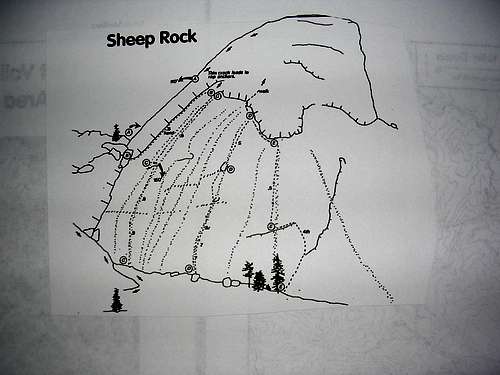
From Ken Trout's South Platte guidebook. Lower Velcro Wall routes.
These routes range in difficulty from 5.6 to 5.9, and have either bolts or require trad gear and knowledge. All routes top out the same on top of Sheeprock. I have only climbed 2 of these routes.
A - Acid Crack (not shown) 5.5 - An excellent mixed gear trad climb.
B - Skink 5.6
C - Sheep Just Wanna Have Fun 5.9R
D - Velcro Strip 5.7R
E - CMC Route 5.5
F - Bolted Route 5.7+ (old school rating) - not shown - an excellent face climb on thin holds. Can definitely be a little spooky, but it is bolted, so definitely not as scary. Excellent fun.
I believe (but have not yet personally verified) that the new belay anchors on top of South Ramp can be used with LONG runners to make a TR setup for most of these routes on Lower Velcro Wall.
All routes that end up on the summit require rappelling with either (1) 70m rope to a belay and another rappel, or using (2) 60m ropes for a full length rappel. If you rappel the south ramp face, you must have (2) 60m ropes.
BOOKS!
For reference, in addition to MP.com, I recommend keeping an eye open for these books:
South Platte Rock Climbing, and Garden of the Gods, by Peter Hubbel and Mark Rolofson, 1988 Chockstone Press
South Platte Climbing - Northern Volume (does not include Sheeprock, but Vol. 2 (Southern Volume) not yet released), byJason Haas, Ben Schneider, Craig Weinhold
South Platte, The Rock Climbers Guide, by Peter Hubbel, 1997 Chockstone Press.
South Platte Rock, by Ken Trout. 1997 Sharp End Publishing.
All guidebooks for this area are out of print. Hubbel's '97 has some impressive editing errors, therefore I recommend getting both editions.