
-
 11859 Hits
-
 81.18% Score
-
 13 Votes
|
|
Mountain/Rock |
|---|---|
|
|
44.56153°N / 111.68292°W |
|
|
Hiking |
|
|
Spring, Summer, Fall, Winter |
|
|
9855 ft / 3004 m |
|
|
Overview
 View to the East
Taylor Mountain lies along the Continental Divide on the border of Idaho and Montana, approximately 12 miles directly to the west of Sawtell Peak.
With an elevation of 9,855 feet, Taylor Mountain is only 11 feet lower than Sawtell Peak. The peak looks down on Henrys Lake basin and Upper Red Rock lake to the north. Views to the south look out over the Island Park Reservoir basin. On clear days the Tetons can be seen in the distance to the southeast.
Getting There
 Shelley on the Summit
Camping
 View to the South
Taylor mountain is located in the Targhee National Forest. Refer to the forest website for details on camping.
Bear Precautions
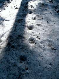 Bear Tracks
Both grizzly and black bears are found in the area. Several of the most important precautions for safe travel in bear country include the following:
• Do not hike alone; travel in groups and stay together
• Announce your presence by making loud noise as you hike
• Do not hike at night
• Never store food in a tent; suspend food from a tree or bear pole
• Never approach wildlife; keep a safe distance
When to Climb
 The Hike Out
Snow-free climbing will be found from late June until the first major snowfall of the season. Skis or snowshoes will be required outside of this timeframe.
Weather and Climate
Always be prepared with warm clothing and rain gear, even on warm and sunny summer days.Nearby weather forecast.
Taylor Creek Route
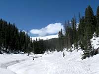 The Hike Out
Due to the remote nature of this peak, I've elected to post a route description in the main page, rather than a separate route. Other routes certainly exist, so feel free to post them and I will modify this section accordingly.
Both the east and west ridges appear to offer straightforward routes to the summit. The peak cliffs out to the north, so approaches from that direction are unlikely.
This route was climbed in the Spring, with snowshoes worn virtually from the vehicle, so a snow-free ascent will probably vary somewhat from this route description.
UTM coordinates appear in blue.
Beginning of Forest Road 035: 12 T 0449190E 4926320N, el. 6615 ft.
If road 035 is not passible by vehicle, park at the above coordinate where road 035 leaves Kilgore-Yale road on the north, and begin following Road 035 to the north then west for approximately 0.9 miles. Look for a sign on the north indicating the road (Forest Road 037) up Taylor Creek (12 T 0447936E 4925499N), el. 6602 ft., and continue northward on this road. After approximately 2 miles the road will open up into a semi-flat clearing (12 T 0444944E 4931880N), el. 8000 ft. At this point begin heading up the steeper slopes to the northeast. Contine northward up the slope for approximately 2.5 more miles to the summit.
Round-trip hiking distance - ±12.0 miles
(from start of Road 035)
Elevation gain - ±3,240 feet