
-
 16622 Hits
-
 84.82% Score
-
 19 Votes
|
|
Mountain/Rock |
|---|---|
|
|
34.71740°N / 83.8382°W |
|
|
White |
|
|
Spring, Summer, Fall, Winter |
|
|
3780 ft / 1152 m |
|
|
Overview
 Cowrock Mountain from Wildcat Mountain
Wildcat Mountain holds the distinction to peak nerds of being the 35th highest peak with 300 feet or more prominence within the state of Georgia. It’s perhaps known to normal folk as a hike offering great, wide-open views from the bare-rock overlook below the summit. It’s surely known to many backpackers spending the night in the Whitley Gap Shelter as that darn hill they’ve got to re-climb before re-gainng the AT.
Wildcat Mountain is a beauty of a peak. From Cowrock Mountain to the west, the peak looks strong and dramatic, steeply sloping into the Town Creek Drainage. The views from the mountain’s overlook are wide open, and winds rushing up the slope are exhilarating. Many Appalachian Trail hikers blaze right past this lovely little mountain, but don’t even think about it. A short, on-trail side-trip will get you to some of the best views in the region. Your legs will forgive you the extra effort.
Rank: 35th highest peak in Georgia
Prominence: 640 feet
USGS Quad: Cowrock
Planning Map: Appalachian Trail Conservancy Springer Mountain to Bly Gap GEORGIA
Rank & Prominence: Lists of John
Getting There & Route Information
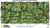 Area Map
 Route Map
The summit of Wildcat Mountain sites approximately 6/10ths of a mile off the AT on the Whitley Gap Shelter side-trail. Simply follow the blue-blazes to the overlook. The actual summit is not far past the wide-open views and is indistinct and tree-covered.
The nearest road to Wildcat Mountain is GA Route 348. Parking at Hogpen Gap off GA 348, the summit of Wildcat Mountain can be reached via a hike of less than 2 miles roundtrip and 300 feet of net elevation gain.
For those backpacking the AT, this mountain makes a great lunch spot and place to take a break. It’s understandable to not want to add the mileage to one’s day, but trust me when I tell you, on a clear day, no one will regret a visit to the overlook of this peak.
Red Tape & Special Considerations
 Raven Cliffs Wilderness
 GA SR 348
There is no fee to visit this part of the Chattahoochee National Forest and permits are not required for overnight stays in the backcountry. Please be mindful of posted Forest Service user warnings, such as “problem bear” alerts and campfire bans. Note that the Appalachian Trail is open to foot traffic only. Motorized vehicles and pack animals are not permitted. Wildcat Mountain lies within the 9,100 acre Raven Cliffs Wilderness. Please practice Leave No Trace principals:
1. Plan Ahead and Prepare
2. Travel and Camp on Durable Surfaces
3. Dispose of Waste Properly
4. Leave What You Find
5. Minimize Campfire Impacts
6. Respect Wildlife
7. Be Considerate of Other Visitors
Camping & Lodging
 Wide Open Views
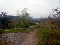 Across the open ridge-line
 Outcrop along ridge
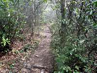 Jungle Trail
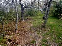 True Summit is here somewhere
AT Backpacker Camping
• The nearest shelter to Cowrock Mountain is the Whitley Gap Shelter. Due to proximity to GA SR 348, this shelter is said to fill up with casual weekend traffic.
• Low Gap Shelter, 4.4 mile northbound on the AT from Hogpen Gap at GA SR 348, is an excellent choice for backcountry accommodations. A burbling brook runs past the shelter, which is downhill from the AT, while some fine tent camping options can be found uphill from the shelter on the side-trail.
Hiker Hostel
The Walasi-Yi Center at Neels Gap has lodging in their historic hiker hostel. The hostel is open 7 days a week, 365 days a year, lodging is available on a first come, first served basis.
 Southward down Town Creek
Weather & Seasons
| Spring and Fall are considered by many the most pleasant time to visit the Southern Appalachians. Spring: In the Spring, daytime temperatures and warm and evenings are cool while the flowering shrubs are in bloom and the waterfalls are running. Water sources such as springs are most reliable this time of year. Fall: In the fall, the broadleaf deciduous trees put on a bright display of autumn color, though waterfalls may not be as impressive and springs and other water sources less reliable. The air is cooler and crisper and visibility should be prime for long-range views. Summer: in this part of the country can be oppressively hot and humid and even the higher elevation and ample tree cover will not keep the hiker from feeling overheated, sticky and dirty. High humidity and haze plus deep leaf cover mean limited long-range vistas, though it is in summer that the term “temperate rainforest” will have the most meaning to and be most appreciated by the visitor. Winter: in the South Appalachians can range from cool and damp to cold and severe with bouts of deep snow following major storms. In other words, while this range may be relatively low in elevation and southern in latitude, mountains are still mountains and can bring unpredictable and potentially dangerous weather. | 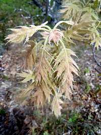 Spring Oak Leaves Spring Oak Leaves |