
|
|
Mountain/Rock |
|---|---|
|
|
46.87193°N / 121.59741°W |
|
|
Pierce |
|
|
Hiking, Mountaineering, Scrambling |
|
|
Summer, Fall |
|
|
6790 ft / 2070 m |
|
|
Overview
Scenic Tamanos Mountain
Tamanos Mountain is a scenic peak located in the east central part of Mount Rainier National Park, Washington. It is prominently seen from Sunrise Ridge to the north, and it catches the eye in early evening as the sun begins to set on its northwest face.
Tamanos Mountain is a northeast extension of the ridge connecting to the beautiful Cowlitz Chimney's. Governor's Ridge and Barrier Peak lie to the east/southeast across the Shaw Creek valley. Tamanos is bordered on the east by Shaw Creek, on the west by Fryingpan Creek and Wright Creek, and to the north by the White River.
From the craggy summit of Tamanos one can have a most impressive view west of Mount Rainier and Little Tahoma, rising thousands of feet higher, just a few miles away. To the southwest the triplets of the Cowlitz Chimneys and their Sarvant Glaciers add extra eye appeal. While approaching the peak from the south views can be had of Mount Adams, Mount Hood, and the Goat Rocks Wilderness far to the south. However, a series of false summits block unimpeded views of these peaks from the true summit of Tamanos Mountain.
A scenic way-trail leads away from just past Owyhigh Lakes to the southern most false summit of Tamanos Mountain. In some places the trail nearly disappears in a display of wildflowers. Columbine, Pasque Flowers, Lupine, and Paintbrush dominate the lush meadows of the southwest slopes of Tamanos. Upon approaching the saddle, the way-trail becomes clear and is a simple matter of walking up the steep southern slopes.

Summit ridge of Tamanos Mountain

View on northeast side of Tamanos Mountain
The true summit is harder to reach. Most people who hike up Tamanos Mountain, which is not very many, avoid the rotten rock along triple spires of false summits that lead north.
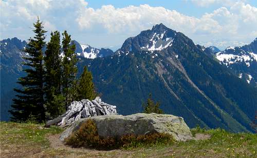
The summit is a worthy prize. Views of Mount Adams and the Cowlitz Chimneys can be had to the south and southwest. Little Tahoma's summit can barely be seen jutting up against the bulk of might Mount Rainier to the west. Goat Island Mountain, Burrough's Mountain and Sunrise Ridge are less scenic to the northwest and north. Glacier Peak and Mount Stuart are visible to the north and northeast. To the east distant peaks of the Chinook Pass and nearby wilderness area peaks can be had. Closer at hand, to the southwest, is the serrated Governor's Ridge and Barrier Peak.
Getting to Tamanos Mountain

Cowlitz Chimney group from the saddle of Tamanos Mountain

View of Tamanos from near Owyhigh Lakes
Overall elevation gain from the White River valley to the summit of Tamanos is just over 3,000 feet.
Drive to the Owyhigh Lakes trailhead, not far from the White River Campground, Mount Rainier National Park. A steady hike of 3.5 miles leads up to the recently avalanche debris filled Owyhigh Lakes overlook. The water is incredibly sweet and one must certainly stop for a drink.
From the lake continue along the trail for a quarter of a mile through Pacific Silver Fir forest. The trail comes out into a broad meadow with a stunning view of the Cowlitz Chimneys. Take the way-trail that leads to the right (west) and follow it up the steep mountainside to the base of Tamanos Mountain.

Summit approach

Goat Rocks Wilderness and Double Peak
Head straight for an obvious saddle, with the southwest slope of Tamanos on the right (north). The trail may be lost in the meadow. Upon reaching the saddle the trail becomes clear as it leads up the southern slopes of Tamanos. After a steep hike of several hundred feet the false (southern) summit is reached.
Head down the left (west) side of the next highest rocky summit, then scramble up to a gap between that summit and another false summit. From there a scant way-trail can be made out crossing loose rocks above a nearly vertical drop off. Follow this path past a third outcrop of rock before finally gaining the main ridge, bordered by a cliff on the east and the sloping drop off to the west. Scramble along the ridge to the base of the summit block. From there a short, but steep scramble past a few trees and up loose rock leads to the summit. Make sure your handholds are solid because the rock is fragile.
Red Tape for Tamanos Mountain

Governor's Ridge and Barrier Peak from summit

Mount Rainier from the summit
Cost to get into Mount Rainier National Park, via the White River Entrance is $15.00.
Camping

View of Mount Adams to the south

Meadows on Tamanos Mountain
Several camping options are available, depending on how wild you want your Tamanos experience to be. The White River campground is only a couple miles from the trailhead. The cost is $12 per night. Another option is Tamanos Camp, located nearly 3 miles up the Owyhigh Lakes Trail. The best, but probably most mosquito-infested option, is to camp off-trail near Owyhigh Lakes. Scenic views of Governor's Ridge and the east slopes of Tamanos can be had from the lakeshore area.
An abundance of wildflowers

The Cowlitz Chimneys overlook Western Anemone and Asters on Tamanos Mountain

Spreading Phlox

Western Pasque Flower
Approaching the southwest slopes of Tamanos Mountain is like stepping into another Mount Rainier Paradise. Thousands of wildflowers greet the senses with dozens of colors and variety. Late spring snows helped to make early September on Tamanos Mountain a peak time for wildflowers; and more are just starting to bloom. Glacier Lily, Indian Paintbrush, Magenta Paintbrush, Lupine, Pasque Flower, Spreading Phlox, Scarlet Columbine, and Purple Asters are just a sample of the flower show put on around the climber ascending Tamanos Mountain.

Western Anemone

Magenta Paintbrush
Tamanos Mountain

NE Face of Tamanos Mountain

View from near Sunrise Camp

View down the cliff into Fryingpan Creek

Tamanos Mountain

A posing Gray Jay on the way up Tamanos

View of largest Owyhigh Lake

Late Spring avalanche on Tamanos Mountain

Loose rock summit traverse on Tamanos Mountain