|
|
Mountain/Rock |
|---|---|
|
|
40.42590°N / 108.766°W |
|
|
Moffat |
|
|
Hiking |
|
|
Spring, Summer, Fall |
|
|
8717 ft / 2657 m |
|
|

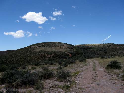 Summit area in distance
 Overview
I originally created an album for a visit to this out of the way mountain but Sarah Simon was concerned that an album for a mountain that didn't have a page on summitpost would get "lost". I promised Sarah that I would make a mountain page for Tanks Peak so that wouldn't happen and this is the belated response to that promise.Tanks Peak is located in Moffat county in the far western side of the state of Colorado. There is nothing about Tanks Peak that would attract any attention from peakbaggers of any kind if it weren't for the fact that it is the 61st most prominent peak in the state of Colorado. For those who think of Colorado only in the terms of lofty peaks soaring well over 13 or 14 thousand feet, a peak that has only 8717' of elevation seems out of place. Yet, Colorado is a very diverse state and has mountains and plains and as in the case of Tanks Peak, peaks that aren't overly lofty or even very pretty. Tanks Peak is really in cattle country and the highest spot is on a broad plateau.
Fortunately, it is located close enough to Dinosaur National Monument to make it something you could add as part of a visit to the monument.
Getting There
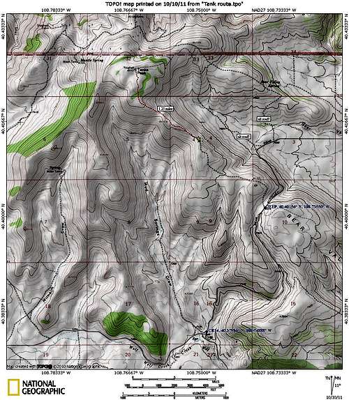
From either Vernal Utah or elsewhere, take highway 40 and head for the small community of Dinosaur Colorado. Located just a mile or so outside of town on the east side, look for the Dinosaur National Monument Visitor Center. The center is worth a stop and a good place to get information about roads and conditions. The road next to the visitor center that heads north is called Harpers Corner road (on the Benchmark map atlas) and is the road you want.Take it north for 11 (roughly) and watch for county road 16 (not long after you pass the Escalante Overlook), a well graded gravel/dirt road that takes off to the east. Take this road another 12-13 miles and watch for country road 14 coming in from the north (see route map). Make a left onto this road and follow it
for a 2.5 miles until it crests and begins to drop down into the next valley. At the crest is a jeep type road that is strictly 4WD and high clearance and heads uphill to the north through a cattle area. The first mile is rough and nasty and it'd be best to park and hoof it from there unless you have a sturdy vehicle. I did notice on the map another couple road possibilities (see route map) further north on CR 14 but have no personal experience with that road. Study your maps and perhaps you will find a better road than I did. I followed the rough jeep track for about two and a half miles and then parked and walked the rest of the way.
 The jeep road
 Red Tape
None that I am aware of.Camping
Nearby Dinosaur National Monument has several campgrounds to choose from and has provided an information page for these HERE.It is probable that you could car camp in the Tanks Peak area but it would be recommended that you utilize a low impact style and pack out any garbage.
Motel accomodations are available in Vernal Utah and Craig Colorado.
Weather
Dinosaur ColoradoSummit stuff
 View north View north |  View NW View NW |  Plateau top Plateau top |
 Summit area in distance
  register register |  register register |  cairn & BM cairn & BM |
According to Lists of John, as of October 2011, the following have visited the summit:
AndyMartin
Bob Martin
BobPackard
DeanMolen
John Kirk
JohnCollard
johnvitz
kirkmallory
Mike Garratt
MyraK
Renata
Route map