
|
|
Mountain/Rock |
|---|---|
|
|
39.74101°N / 119.70908°W |
|
|
Washoe |
|
|
Hiking |
|
|
Spring, Fall, Winter |
|
|
6024 ft / 1836 m |
|
|
Overview
The Hungry Ridge is a small mountain ridge located, at its center, approximately 15 miles north/northeast of Reno, Nevada. Hiking here offers a pristine desert landscape, just outside areas of population. When hiking to the Hungry Ridge, especially from the standard western approach, one feels like they are miles from civilization, although civilization is actually very close.The Hungry Ridge stretches for approximately 6 miles north-south and is about 1 ½ miles wide at the heart of the range. Because the primary summits in this range can easily be done in a day hike, it is best expressed as a mountain/rock page.
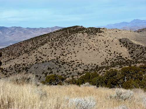
View of the Hungry Ridge - North and South - from the west
There are basically three primary summits along the ridge, but only two that are named. The summit furthest to the south is Point 5963 (not specified as a summit or point on topographic maps). This looks prominent from the valley to the west, but only rises 163’ above its saddle with the named Hungry Ridge South 6020’, which itself is about 1 mile to the north of Point 5963.
Hungry Ridge North 6024’ is the highest point on the ridge. It is about 1 ¼ miles north of Hungry Ridge South. Hungry Ridge South has a prominence of just over 400’ from its saddle with the North summit. Hungry Ridge North has a prominence of about 900’. The next highest mountain is Spanish BM 6161', which is the main mountain ridge to the south of Hungry Ridge.
The Hungry Ridge is best approached from the west side on public lands. There is potentially access from the east, but the area is mostly private lands, and if there are any legal approaches, they are short, steep, and not altogether scenic. If anyone has approached this way and has further details, please let me know.
From the summits of Hungry Ridge South and North there are plenty of great views with mountains in all directions. Although the giant Pyramid Lake is only 15 miles away as the crow flies from the northern summit, it is not visible. Yet, the Sierra Nevada range to the southwest, is clearly visible.
The best time to hike here is probably late fall/early winter, when it is still dry and snow free, but not too warm. Spring is possible, but beware of muddy conditions.
Hungry Ridge North coordinates are given for this page.
Hungry Ridge South coordinates are: 39.724402, -119.715094
Point 5963 coordinates are: 39.711556, -119.724422
The Hungry Ridge is not to be confused with Hungry Mountain 5947’, which is approximately 4 ½ miles to the west.
Getting There
From Reno take I-80 east to Pyramid Highway (445). Take 445 north for about 7.7 miles and turn left at the stoplight for Eagle Canyon Road. Follow the signs around traffic circles to stay on Eagle Canyon Road. Eventually you will pass Spanish Springs High School. Stay on the road and continue past the sign for the Reno/Sparks Indian Colony about 5 miles further up the road. This a federal tribal colony, technically on tribal lands managed by the Bureau of Indian Affairs. Access is not restricted, but the parking area described below is at the border between tribal lands and Bureau of Land Management (BLM) lands.After driving past the colony (basically a bunch of homes), the Eagle Canyon road turns west back into the residential area. At this point, there is a sign for Fancy Dance Drive on the left side of the road. Loop Road is on the right side, but unmarked. Take this road, which quickly turns into a wide, well graded dirt road. Follow it for about a mile, and it ends at another dirt road. Take a right, and pass a building and a fenced off wellhead. After another quarter mile the road ends at a gate on federal lands. This is a good place to park, although you can open the gate and a 4WD can easily head up the road to the start of the canyon. The route information described below assumes the gate as the starting point.
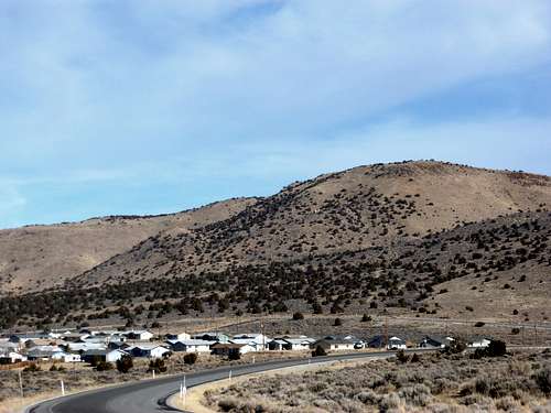
Point 5963 is the first prominent summit seen when entering the area. Here it is rising above the Reno/Sparks Indian Colony
Route Information
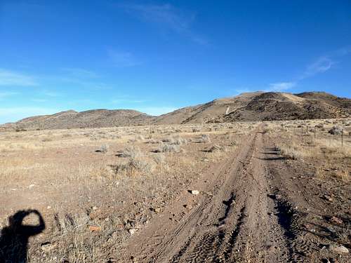
From the gate at about 4885’, head straight up the road for a little over ½ mile. You will be able to follow dirt roads as they head towards the foot of the mountains. Then a side road heads directly into the canyon. See the photo below showing the entrance point into the canyon. Even if you have to get off the road, find your way towards the entrance into this canyon. Once there it is pretty self explanatory.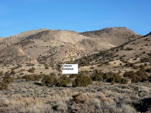
Canyon entrance
Once in the canyon (starts at about 5100’), the road winds up through the brushy desert landscape, eventually turning into a trail. After about 1 ¼ miles, it meets up with the road that runs along the ridge-top. At this point, you have achieved a net gain of about 1,000’ from where you started. The summit of Hungry Ridge South is about 1/3rd of a mile away.
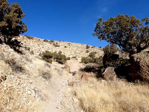
Heading up the canyon
Getting to Hungry Ridge North from Hungry Ridge South is pretty simple. Get back to the road below the summit and head north. The road descends to 5614’ at the saddle, and then hits a steep section of road that climbs almost 300’ in about ¼ mile. Once the road flattens out, continue on the road for another two-tenths of a mile. Then bushwhack a final tenth of a mile up to the summit.
Hungry Ridge North summit from Hungry Ridge South summit
For the descent, there are a couple options. You can go back the way you came, or take a road in between Hungry Ridge North and South. This road starts a little after you reach the base of the big hill below the Northern summit, about 2/3rd of a mile to the south. Take this road and after about a mile it reaches a junction with another road heading south along the foot of the mountains. Take this road which becomes the main road you took at the start of the hike. Once you reach the junction at the ridge-top, it is 2 ¼ miles back to the gate.
If you go back the way you came, the total round trip mileage for both primary summits is about 7 ½ miles. If taking the alternate descent route, the round trip mileage is about 6 ¾ miles. Elevation gain for both summits is about 1650’.
Other notes on the route
I did not give directions to Point 5963, because it is not prominent, nor does it have any marker, nor does it have very good views from the summit. If you wish to reach it, however, take the road south from the ridge where it meets the road from the canyon. Head down the road a little less than a mile and find your way up. The summit is not obvious. You just have to find what appears to be the highest point.
There are other potential routes. Although most involving bushwhacking straight up the hillside. However, the trail is far more scenic, straightforward, and enjoyable.