
-
 12939 Hits
-
 77.48% Score
-
 8 Votes
|
|
Mountain/Rock |
|---|---|
|
|
13.59602°N / 88.83725°W |
|
|
Hiking |
|
|
Spring, Summer, Fall, Winter |
|
|
7159 ft / 2182 m |
|
|
page best viewed in widescreen![Chichontepec]() The entrance to the military base on topA centrally located, very large volcano in El Salvador, Volcán San Vicente (also commonly known as Chichontepec, meaning something along the lines of "mountain of two breasts" in the native Nahuat language, owing to the fact that there are two summits next to each other high up on the cone) is a staple of most any El Salvador visit. Having lived very near it during my Peace Corps service, I can assure you that the incredible bulk of this mountain is seen from almost every corner of the tiny country of El Salvador and that everybody knows somebody who knows somebody who climbed it. (But you will rarely find someone who actually has).
The entrance to the military base on topA centrally located, very large volcano in El Salvador, Volcán San Vicente (also commonly known as Chichontepec, meaning something along the lines of "mountain of two breasts" in the native Nahuat language, owing to the fact that there are two summits next to each other high up on the cone) is a staple of most any El Salvador visit. Having lived very near it during my Peace Corps service, I can assure you that the incredible bulk of this mountain is seen from almost every corner of the tiny country of El Salvador and that everybody knows somebody who knows somebody who climbed it. (But you will rarely find someone who actually has).
Rising a solid 1400m above the surrounding terrain, the massive twin-peaked volcano is a currently inactive stratovolcano that, though it has not erupted in a very long time, maintains its bulk and presence quite well. Chichontepec is one of the "big three" volcanoes in El Salvador, the others being Santa Ana and San Miguel. Hot springs and other natural thermal features surround its flanks, constant reminders that it is not just another mountain, but a volcano biding its time. The volcanos flanks are mostly covered with coffee plantations, with only the very top of the cone forested by natural forest.
![Summit view San Vicente Volcano]() The view west towards San Salvador
The view west towards San Salvador
This volcano presents a long, complicated, view-less, hot, humid hike to the top but once you are there the vistas on a clear day are incredible. The hike is not a very pretty one, and there are absolutely no views until the top, but once you get to the military base the sits atop the eastern summit (the higher of the two), the trees are either stunted or cut down and the views from the helicopter pad are amazing. When I hiked it, you could see clear from the Santa Ana volcano in the west of El Salvador to the San Miguel volcano in the east, and clear to the border mountains with Honduras and the ocean. Probably at least 60-75% of the country in view. Incredible!![San Vicente]() I would never say never, but if you want to climb this peak I believe you need to know Spanish to hook yourself up with a guide and figure out the route. Anyone who has spent time in Latin America knows the laid-back nature of life and that if you try things on your own and ask directions, every single person gives you a different answer. Your best bet is to get a guide.
I would never say never, but if you want to climb this peak I believe you need to know Spanish to hook yourself up with a guide and figure out the route. Anyone who has spent time in Latin America knows the laid-back nature of life and that if you try things on your own and ask directions, every single person gives you a different answer. Your best bet is to get a guide.
This hike is complicated because of the fact that there are no established trails or routes. The easiest way to get up is to find someone who knows how to get there, and have them lead you. There are no trailheads, or even trails. Just footpaths that people use. This section is not intended to be directly informational: there is not any good information on how to climb it properly. I just want to pass on everything I learned while living down there for you to figure it out.
They say that it can be climbed from almost any side: San Vicente, Tepetitan, Guadelupe, Tecoluca, Zacatecoluca, wherever. Basically the standard official process goes like this: you go and find the local Alcaldia (mayor's office) and ask about the tourism people, they (might) hook you up with a guide and also some "tourism police" to accompany you. Then, you theoretically would drive up as high as you can get with your 4x4 into the coffee fincas, and park your car, hiking the rest of the way (hoping that your guide knows what he is doing). All of these services are free, the guide and the police escort, but you must go ask for them, and it could be a few days after asking that somebody could go. In my experience usually these people are dying to get out and love to tag along. It is, of course, customary to provide some food and maybe a small tip to them on the hike. The police are a very good idea to have along, regardless of whether you use a guide, because of the very high likelihood of potential robbery. The volcanoes of El Salvador are crawling with people who just might want to see if you have any good stuff in that bag...
![Chichontepec]() View from the west, near my Peace Corps house
View from the west, near my Peace Corps house
When I climbed it, I was with a field expedition from a University doing research high up on the volcano. We got permission to drive our trucks literally as high as the road went, and only had to hike ~1 hour to the top. This is uncommon. I have heard that, depending on where you start your hike, it can be as much as a 8-10 hour round-trip, so start out early! The weather near the bottom, as with most of Central America, is HOT but the higher altitudes at the top make for a pleasant temperature. When we climbed it, the temp was probably upper 60s at the top and we started the hike into the jungle in long sleeves, after having left San Vicente at 8am sweating in shorts and a t-shirt. Just FYI.
Also worth noting: this volcano is best left unclimbed in the rainy season, due to the high possibility of landslides. This window lasts ~June thru October, and while it is possible to do the climb during this time, the paths (at best) would be soupy mud and you would just be taking unreasonable risk. Climb it November thru May for the best results, and almost guaranteed sunny weather.
Global Volcanism Program
USGS Site
SNET Hazard Map
Informative MTU Page
Overview
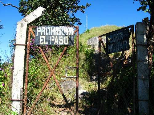 The entrance to the military base on top
Rising a solid 1400m above the surrounding terrain, the massive twin-peaked volcano is a currently inactive stratovolcano that, though it has not erupted in a very long time, maintains its bulk and presence quite well. Chichontepec is one of the "big three" volcanoes in El Salvador, the others being Santa Ana and San Miguel. Hot springs and other natural thermal features surround its flanks, constant reminders that it is not just another mountain, but a volcano biding its time. The volcanos flanks are mostly covered with coffee plantations, with only the very top of the cone forested by natural forest.
 The view west towards San Salvador
This volcano presents a long, complicated, view-less, hot, humid hike to the top but once you are there the vistas on a clear day are incredible. The hike is not a very pretty one, and there are absolutely no views until the top, but once you get to the military base the sits atop the eastern summit (the higher of the two), the trees are either stunted or cut down and the views from the helicopter pad are amazing. When I hiked it, you could see clear from the Santa Ana volcano in the west of El Salvador to the San Miguel volcano in the east, and clear to the border mountains with Honduras and the ocean. Probably at least 60-75% of the country in view. Incredible!
Getting There

This hike is complicated because of the fact that there are no established trails or routes. The easiest way to get up is to find someone who knows how to get there, and have them lead you. There are no trailheads, or even trails. Just footpaths that people use. This section is not intended to be directly informational: there is not any good information on how to climb it properly. I just want to pass on everything I learned while living down there for you to figure it out.
They say that it can be climbed from almost any side: San Vicente, Tepetitan, Guadelupe, Tecoluca, Zacatecoluca, wherever. Basically the standard official process goes like this: you go and find the local Alcaldia (mayor's office) and ask about the tourism people, they (might) hook you up with a guide and also some "tourism police" to accompany you. Then, you theoretically would drive up as high as you can get with your 4x4 into the coffee fincas, and park your car, hiking the rest of the way (hoping that your guide knows what he is doing). All of these services are free, the guide and the police escort, but you must go ask for them, and it could be a few days after asking that somebody could go. In my experience usually these people are dying to get out and love to tag along. It is, of course, customary to provide some food and maybe a small tip to them on the hike. The police are a very good idea to have along, regardless of whether you use a guide, because of the very high likelihood of potential robbery. The volcanoes of El Salvador are crawling with people who just might want to see if you have any good stuff in that bag...
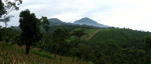 View from the west, near my Peace Corps house
When I climbed it, I was with a field expedition from a University doing research high up on the volcano. We got permission to drive our trucks literally as high as the road went, and only had to hike ~1 hour to the top. This is uncommon. I have heard that, depending on where you start your hike, it can be as much as a 8-10 hour round-trip, so start out early! The weather near the bottom, as with most of Central America, is HOT but the higher altitudes at the top make for a pleasant temperature. When we climbed it, the temp was probably upper 60s at the top and we started the hike into the jungle in long sleeves, after having left San Vicente at 8am sweating in shorts and a t-shirt. Just FYI.
Also worth noting: this volcano is best left unclimbed in the rainy season, due to the high possibility of landslides. This window lasts ~June thru October, and while it is possible to do the climb during this time, the paths (at best) would be soupy mud and you would just be taking unreasonable risk. Climb it November thru May for the best results, and almost guaranteed sunny weather.
Red Tape
No fees that I know of, just tip your guide and provide some food for them on the hike.Camping
Not advised, but I suppose it is possible somewhere?External Links
Additional information:Global Volcanism Program
USGS Site
SNET Hazard Map
Informative MTU Page