
|
|
Mountain/Rock |
|---|---|
|
|
39.87060°N / 116.3104°W |
|
|
Eureka |
|
|
Hiking |
|
|
Spring, Summer, Fall, Winter |
|
|
10134 ft / 3089 m |
|
|
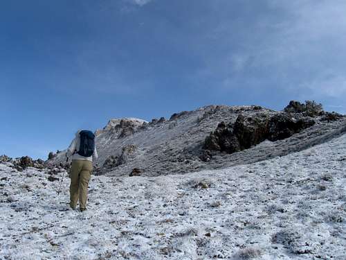
Ken heads for the summit
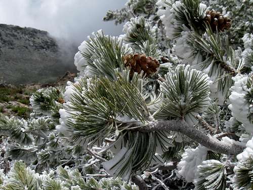
Bristlecone beauty
Overview
Roberts Creek Mountain is located northwest of Eureka Nevada and is one of Nevada's top 100 prominence peaks coming in at #40 on the list. It has almost 3600 feet of prominence and this makes it worth a visit by that group of peakbaggers that is interested in prominence.We found that this mountain gets a bit more visitation than most of the central Nevada peaks that we have visited and it may be due to the amount of roads and jeep tracks in the area. A skillful ATV driver could probably get very close to the summit.
Getting There
From the junction of highways 50 and 278 just a few miles north of Eureka, head north towards Garden Pass, about 22+ plus miles to where you see the sign for the pass. From that sign, continue north about 2 miles and watch for an unsigned road that takes off on the west side of the highway. Cross a fenceline that has information about the wildlife restrictions posted on the fence and take the first right that drops down a hill. (see map) Follow this road as it heads northwest and along the way you'll cross a creek and find that a normal SUV type vehicle will have adequate clearance all the way to the pass that separates Vinini Creek from Roberts Creek drainages.The pass is at 8100 feet and the gps reading I took was 39.8487 / 116.2811
2WD vehicles and even 4WD vehicles could park here or at the beginning of the jeep track just a bit down the hill (see map) The jeep track is extremely rough and may not be worth the beating you will subect your vehicle too. You will save two miles by driving this jeep track but again, it is a very rough nasty track and if I had it to do over again, I would park near the beginning and walk up the road. The elevation gain is slightly over 2000 feet from this point and adds a couple miles if you don't drive the jeep track.
If you do drive the jeep track, you can get all the way up to 9500 feet and within a half mile of the summit. The elevation gain will be just over 600'.

Map of way in from highway 278

Red Tape
None that I am aware of. You can try to find out more by calling the Eureka County natural resources office for information: 775-237-6010.BLM Ely District Office
702 N. Industrial Way
HC 33 Box 33500
Ely NV 89301
Phone: 775-289-1800
Office Hours: 7:30 am - 4:30 pm M-F
BLM Battle Mountain District Office
50 Bastian Road
Battle Mountain NV 89820
775-635-4000
Office Hours: 7:30 am - 4:30 pm M-F
Route
The route I used is shown in map 3. I would recommend against driving the jeep track that took us close to the 9550' level. While I did drive this road, I wouldn't do it again. I would rather hike it and not subject my truck (a 2005 Tacoma) to possible damage. Your call.
Route to summit
 on route
 |  nearing summit
 |  At summit
 |
 summit cairn
 |  Benchmark
 |  Ken
Ken |
Summit register
The summit register was in a PVC pipe and had a crack in it which was allowing water seepage. Having no replacement to provide, I put duct tape on the crack which might help extend the life of the registers within a bit longer. I hope someone will carry a new register container to replace the PVC one. One of the register books was damp and in bad shape while the newer one was doing ok for the time being in a zip lock. This peak sees about two parties a year, many that are hunters and local folks. The familiar names in the register that we could pick out were:
Witness Benchmark
2000 - John Vitz / Victor and Susan Henney
2002 - Gordon MacLeod and Barbara Lilley
2006 - Bill Herbert
2010 - Brad Boester
2011 - Bob Sumner
2012 - Myself, Ken Jones and a week after us, Andy Martin and Mark Nichols
2013 - Dennis Poulin
For updates on others who have visited this summit more recently, check out peakbagger HERE
If you visit this summit, please report back on the condition of the register and I would appreciate if you would also sign the Summitpost register of this page.
Camping and weather
We car camped at a flat spot just off of the highway. See map. There are no organized campgrounds in the area and there are several opportunities for car camping. Please practice the leave no trace ethic. There are several motels in nearby Eureka as well as an RV camp area.
Click for weather forecast

Click for weather forecast
Peakbagger trip reports & my report
Ken JonesBrad Boester
Kens TR has a gps track that goes from where we parked at the saddle and Brad's TR follows the route up that we took.
MY TR:
Ken and I started our Memorial day trip on friday with an ascent of Mount Tenabo in the morning and a hike to the top of Bald Mountain (8543) in the afternoon. The weather had been threatening all day but missed us on Mount Tenabo in the morning and Bald in the afternoon. Our ascent of Mount Tenabo was aided by friendly help from the Barrick mining group and for Bald we found an old ranch road to the south east that put us within two miles and two thousand feet from the summit.
That night we parked just off the road near Garden Pass and hoped for good weather in the morning. When we awakened, we had a good look at Roberts Creek Mountain from where we had camped and we noted that it was white due to being covered with snow. The weather was still iffy but we decided to go as far as we could and determine if we could bag the peak or not. Despite having snow on the road in places, we were still able to drive to the pass at 8100 feet where we got a pretty good look at the jeep track that we had noted on the map. The weather was still holding so I decided to see if I could drive up the jeep road. It was in poor shape and terribly rocky. I carefully made my way up it, once stopping and deciding that i could go no further. After getting out, having a chance to walk up the road a bit, I decided to go for it and hoped that I would not regret it later. The road kept getting worse but yet I was able to find a way through most of the "crux" spots and upon topping a ridge, we noted a small pond below with the road hugging its western side. After a few more nasty rocky areas, the road finally smoothed out at the 9100+ plus elevation mark and led down into a basin where a fork was encountered with a BLM sign noting the end of the road to the left in 0.4 mile. I decided to see what the end of the road looked like and it was reasonable all the way to the end which ended in a saddle at the 9600' mark.
From the saddle where I parked, it was about 1/2 mile and somewhat over 600' to the summit. We found a central benchmark and a witness benchmark, a register tucked inside a PVC pipe container and placed near the top of the large summit cairn. We had outstanding views in all directions but our summit stay was cut short by the changing weather. We just barely made it down off of the nasty jeep road before the storm hit the mountain. We elected to go out via the Roberts Creek Ranch road and see about getting our second mountain of the day, Fagin Peak. We made it out, with two gates to open and close and one large muddy area that fortunately didn't suck up my truck and we found our way to the end of the road near the Echevarria ranch where the storm totally stopped our progress by mounting snow accumulation and a total white out in the direction of Fagin Peak. We turned tail and drove through the snowstorm to Eureka where we thought we might spend the night but no accomodations were available so we continued another 77 miles to Ely where we fortunately spent the night at the La Quinta Inn. The next morning found us heading south to better weather and the Fortification range.
Warning: Please realize that this is an out of the way mountain and if you have a breakdown, you may not encounter others for days. Carry adequate water and food for your needs and let others know where you are heading. Cell service may not be available until you get to the summit itself (and maybe not then).