
|
|
Mountain/Rock |
|---|---|
|
|
41.39809°N / 111.99965°W |
|
|
Weber |
|
|
Trad Climbing |
|
|
Spring, Summer, Fall |
|
|
8400 ft / 2560 m |
|
|
Overview
The London Spire is the tallest of the three Willard Spires which overlook Willard Bay. Willard Bay is a freshwater reservoir located 12 miles northwest of Ogden, Utah on the flood plains of the Great Salt Lake. As the crow flies, the London Spire is located about 0.87 miles (1.4 km) (309 degrees) NW of Willard Peak - the high point of Weber County, Utah.Mountaingazelle on her Wasatch Range (North) page states "Back in the early pioneer times, the three Willard Spires were referred to as The First Presidency, referring to the leadership of the LDS Church."
The London Spire is located in the center, and is a slightly lighter color than its neighbors as well as being the tallest at approximatley 8400 ft.
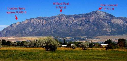 The London Spire, is one of three Spires located about 1.4 km (309 degrees) NW of Willard Peak.
Click here for a terrain map.
Getting There
From north of Willard, Utah: Head south on I-15 to exit 351 on to UT-126. UT-126 becomes US-89 which is the town of Willard’s Main St. Watch for 900 S on the right, pass it, and take your next right. In 2012 this road was not marked, but it might be 655 S, anyways if you come to 600 S you have gone too far, and need to go back one block. Follow the road up to a gravel pit.From south of Willard, Utah: Head north on I-15 to exit 357 on to UT-315. After one mile turn right onto US-89 which is the town of Willard’s Main St. Watch for 600 S on the left, pass it, and take your next right. In 2012 this road was not marked, but it might be 655 S, anyways if you come to 900 S you have gone too far, and need to go back one block. Follow the road up to a gravel pit.
Park outside the gravel pit and walk past the gate heading north east, avoid the main dirt road that heads south from the gravel pit. At the east end of the gravel pit look for a dirt bike trail that goes up the hill in a north east direction, and follow it up. Eventually it will turn south and then east. Continue to follow it until it peters out, at which point make your own way, following the path of least resistance, up the hill side. At the top of the first foothill you'll gain the ridge which leads to the saddle at the base of London Spire. Allow around 3 hours to reach the saddle, and expect both 3rd and 4th class scrambling on dark colored gneiss.
 SW Ridge Approach and Exit Routes.
Routes
 Climb out right on to the completely vertical South face
over a very exposed 1800 foot (plus) drop.
Holds are plentiful as you traverse the breathtaking exposure.
There are at least six routes up the London Spire, ranging from 5.7 to 5.9. The most common route is the southwest ridge which is explained in detail below. Other routes, not described here, include the Direct North Face 5.9 (10 pitches), the Northwest Ridge 5.7 (10 pitches), the Original North Face 5.9 (15 pitches), the South Face 5.7 (10 pitches), and the West Face 5.7.
The southwest ridge route: This route follows the obvious southwest ridge up from the saddle past a prominent bump (aka thumb, or sub-peak) about 2/3 of the way up, and on to the main peak. This picture clearly shows the thumb on the right-hand side.
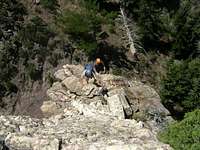
The route advances approximately 1500 vertical feet, and as such can be described as 10 pitches. Experienced climbing parties will likely not need to rope up until just below the crux where one skirts around the thumb. The first 900 ft of climbing is at 5.5 or lower. The first 5.7 section comes about a half pitch length below a large roof on the west side of the thumb. Head up toward the roof, until you come to flat step that is an obvious belay spot. Pull out the rope, if you haven’t already done so, and set up a belay. The route traverses the roof on climber’s right, and is the crux at 5.7 difficulty. Climb out right of the roof on to the completely vertical south face over a very exposed 1800 foot (plus) drop. Holds are plentiful as you traverse the breathtaking exposure. Climb up into a dihedral of sorts and up about 50 feet till the climbing turns easy again and set up a belay.
Once your party has traversed the south face drop, you may wish to simul-climb another half pitch up to a platform near the top of the thumb. From the saddle, between the thumb and the true summit, it is about two more pitches to the top. Careful route finding, on the last two pitches, can ensure the difficulty remains under 5.7, rope up as needed. From the top of the last pitch it is about a 50 yard ridge walk, north east, to the peak.
The rock is fairly solid quartzite, but it is wise to test holds thoroughly before relying on them as several chossy sections exist. A helmut is a good idea. The climb is a series of big steps (so to speak). Basically you occasionally hit some flatter spots that will lead you to the next vertical section.
The best descent is to hike about 30 yard east from the top and then head down the south side, moving as far south as you can. Watch for a wide ramp which slopes down toward the east, this is the key to getting off the London Spire, without rappelling, and down into the east end of Holmes Canyon.
From the bottom of the ramp, continue heading down and east, soon you will naturally turn right into Holmes Canyon. Follow the canyon south west. It’s a long slog out of Holmes Canyon, and you should plan on at least 3.5 hours. Beware of rattle snakes. Eventually you will come to a bike trail that crosses the creek. In 2012 there was a make-shift wood bridge on the bike trail over the creek. Follow the bike trail out of the canyon on the right side. Look for the gravel pit, and make your way back to your car.
Non-Technical Route: It's also possible to leave the rope at home and simple scramble to the top of the London Spire. To do so, go to the town of Mantua (pronounced Man-ta-way), Utah, and take main street going south, which will become Willard Peak road. Follow the rough dirt road for 14 or 15 miles to Willard Campground at about 9,000 ft. 4X4 is not needed but high clearance is. About 2/3 of the way to Willard campground you will pass Perry reservoir on the right, a common hang out for moose. From Willard campground continue on the rough road up to Inspiration Point at 9,422 ft where the road ends. Look south west from Inspiration point and you will see the London Spire. Simply walk down to the spire.
SW Ridge Photographs
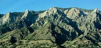 Looking northeast towards the Willard Spires from I-15. Looking northeast towards the Willard Spires from I-15. | 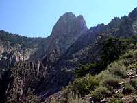 Notice the thumb which is the prominent bump about 2/3 of the way up the London Spire on the right side. The crux involves traversing the thumb on the right side. Notice the thumb which is the prominent bump about 2/3 of the way up the London Spire on the right side. The crux involves traversing the thumb on the right side. |  SW Ridge Route SW Ridge Route |
 The saddle from which the climbing of London Spires begins, via the SW Ridge, is where the rock turns from dark colored gneiss to light color quartzite, as clearly seen in this picture. The route starts out at 5.5 or lower. The saddle from which the climbing of London Spires begins, via the SW Ridge, is where the rock turns from dark colored gneiss to light color quartzite, as clearly seen in this picture. The route starts out at 5.5 or lower. |  From the last pitch it is about a 50 yard ridge walk, north east, to the top of the London Spire. From the last pitch it is about a 50 yard ridge walk, north east, to the top of the London Spire. | 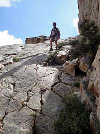 Watch for a wide ramp which slopes down toward the east, this is the key to getting off the London Spire and down into the east end of Holmes Canyon. Watch for a wide ramp which slopes down toward the east, this is the key to getting off the London Spire and down into the east end of Holmes Canyon. |
SW Ridge Slide Show
Camping
The London Spire is just across the freeway (I-15) from the freshwater reservoir known as Willard Bay. The Park at Willard Bay offers camping.From I-15, take exit 357 to reach the North Marina (main park area) and exit 351 to reach the South Marina.
Contact Information:
Willard Bay State Park
900 West 650 North #A
Willard, UT 84340-9999
435-734-9494
Some Numbers
Approximately 10 pitches over 1500 vertical feet. The climbing section, without the approach and descent, is Grade III (half a day) with a 5.7 crux.The author took 3 hours on the approach; 0.5 hours of snack/rest time at saddle; climbing time 3.25 hours; descent time 3.75 hours. Car to Car 10.5 hours.
The gravel pit car parking area is roughly 4500 feet elevation. Base of Spire is roughly at 6900 feet with 1500 feet of climbing to the approximately 8400 foot summit.
The author climbed this via the SW Ridge as a training run for the Upper Exum on the Grand Teton. Having now done both (as of July 21, 2012), I must say the exposure on the crux of the SW Ridge beats the exposure on the Wall Street step on the Grand!
The authors party used 3 pieces of protection on the crux, as well as a few pieces for the belay stations. In other words a basic rack is all that is needed. The key pieces were a pink tricam, one red 1.0 camalot and a couple nuts.
Red Tape
Some of the land is private property, so be mindful of that.External Links
Blog: Levi KepselSW Ridge Route: rockclimbing.com