
-
 17653 Hits
-
 81.84% Score
-
 14 Votes
|
|
Mountain/Rock |
|---|---|
|
|
50.39651°N / 115.78421°W |
|
|
Scrambling |
|
|
Summer, Fall |
|
|
8816 ft / 2687 m |
|
|
Overview
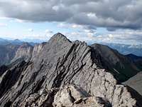
Indian Head Mountain is the highest summit in the Stanford Range of south-eastern British Columbia, Canada. The summit reaches 2687 metres (8850 ft.) and provides excellent views to the Columbia Valley to the west, and views to the Kootenay River to the east. This portion of the Rocky Mountain Trench is the source of the Columbia River which flows from the northern end of Columbia Lake.Indian Head Mountain is often called “Chisel Peak” by locals because of the shape of the summit ridge. Indian Head is very prominent from the Columbia Valley, especially from the area around the Town of Invermere. This summit sees a lot of traffic from local hikers and scramblers. The summit ridge is a fun and exposed scramble with three highpoints along the 600 metre long ridgeline. Generally the southern highpoint is regarded as the summit, but all three highpoints are easy to scramble and only minutes apart from the standard south ridge route. The traverse to the northern summit cairn is the highlight of the scramble.
Getting There
The Stanford Range is surrounded by roads. Two primary highways, highway 93 along the northern edge in Kootenay National Park, and highway 93/95 in the Columbia Valley provide access to the region. Highway 93 connects to the Banff National Park and the Trans Canada Highway with Canmore about 170 kilometres from the northern Columbia Valley town of Invermere. Calgary is about 270 kilometres from Invermere.Highway 95 travels north to Golden, where it connects to the Trans Canada Highway, and combined highway numbering of 93/95 travels from Radium south to Cranbrook. Highway 93/95 is the region’s primary highway. From Invermere drive south on Highway 93/95 about 12 km and turn left (east) onto Kootenay Road #3. Take the first right, soon after exit off 93/95, about 2 km from the highway there will be a sign for Madias Creek Forest Service Road, take this road, on your left. In about 1.0 km the splits into a Y, take the right turn. In another 1 km at the Y, take the left side, staying on the Madias Creek FSR. Stay to the right until a washout over the road is reached in about 2 km. Recommended to park here, in 2012 this washout became even larger and rougher, not worth the effort to drive across.

|
 |
 |
|---|
Red Tape
Essentially there is none. The majority of the Stanford Range is B.C. Crown Land. Crown Land is generally available for camping anywhere, unless leased to a specific party for resource development, farming or ranching. Any leased area are generally signed as such. No fee or registration required for parking, camping or climbing. Wear bright clothes during hunting season!When to Climb
Typical Canadian Rockies situation with July and August providing the driest conditions.Approach
From the washout follow the old logging road for about 2 km to the end of the road, approximately GR 834858. A good trail is visible to the right, this well packed and clear trail leads to a col west of Indian Head Mountain. During our approach in July 2012, a major wind storm pushed down many large trees over the trail requiring many detours into the bush. Once the col (GR 851830) head up the treed west ridge of Indian Head.Route Descriptions
The only published information on Indian Head Mountain is in the excellent guidebook, “Hikes around Invermere and the Columba River Valley” by Aaron Cameron and Matt Gunn.This guide describes an easy ascent of the west and then south ridge of Indian Head Mountain (Class 4) and a traverse from the summit of Indian Head Mountain to Mt. Aeneas (Class 4).
- South Ridge (Difficult/Moderate Scrambling - Class 4)
From the col head straight up the west ridge. Once out of the trees the ridge is an easy hike. Near the top of the west ridge, the angle steepens with several short steps (moderate scrambling, Class 3). Where the west ridge ends on the south summit ridge, there are several moderate steps.

|
 |
 |
|---|
Once on the south ridge an easy hike on solid rocks leads to the south summit. Great views to the Columbia Valley, Kootenay River and the surrounding Stanford Range. The summit ridge heads north to the central and most northern summit.

|
 |
 |
|---|
From the south summit to the central summit is an easy walk, then the final section to gain the north summit is the best part of the trip. Staying on the ridge crest, or even slightly on the steep and exposed west face, is recommend for those who enjoy the exposure (Class 4). Easier terrain can be found on the right, east, side of the ridge (Class 3). The north summit contains the summit register. Return the same way.

|
 |
 |
|---|
|
 |
 |
|---|
- Traverse from Indian Head Mountain to Mt. Aeneas – South to North (Difficult/Moderate Scrambling - Class 4)
From the summit of Indian Head Mountain head north towards an outlier, there are a few steep steps along the ridge crest. From the first highpoint drop to a treed col, then ascend the south side of the highpoint GR 871856 (2667 metres) Unofficial Name (50:25:06 | -115:46:34). From this summit, steep and loose ridge descends to the col between GR871856 (Aeneas SE1) and Mt. Aeneas. An easy scree walk to summit of Mt. Aeneas follows. From the summit descend the standard north slopes scramble route towards Pedley Pass and Windermere Creek parking area. A second vehicle for a shuttle back to Madias Creek parking area is recommended.

|
 |
 |
|---|