
-
 11823 Hits
-
 86.37% Score
-
 22 Votes
|
|
Mountain/Rock |
|---|---|
|
|
41.37088°N / 122.20681°W |
|
|
Siskiyou |
|
|
Hiking, Scrambling |
|
|
Spring, Summer, Fall, Winter |
|
|
9193 ft / 2802 m |
|
|
Overview
 Green Butte and Mount Shasta from the Old Ski Bowl Trail
Few places on Mount Shasta, California’s magnificent Cascade volcano, sees as much traffic as the Old Ski Bowl. The Bowl is the terminus of the Everitt Memorial Highway, the only paved road on Mount Shasta. The Old Ski Bowl attracts people because of its ease of driving, spectacular views of Mount Shasta and the regions to the west and south and the numerous trails that depart from the trailhead at road’s end. Greeting all these visitors is majestic Green Butte. Though it is only a prominent point on one of Shasta’s trio of southwestern ridges (Casaval, Green Butte and Sargents), it remains a beautiful crag worthy of admiration in its own right.
Standing dramatically over Mount Shasta’s Old Ski Bowl, Green Butte is one of the great mountain’s most recognizable features. Anyone who has driven up to the Old Ski Bowl has seen Green Butte towering dramatically over the parking lot. The butte’s eastern face is an extremely rugged and sheer cliff soaring 1,300 feet over the parking area and Old Ski Bowl trailhead. Although it looks like a prominent peak, somewhat independent of the rest of Mount Shasta, it is in fact a large salient bulging out of the otherwise knife-narrow Green Butte Ridge. The southeastern side of the butte is the sheerest and most rugged. The aforementioned cliff rises directly out of the Old Ski Bowl in one massive cliff. Unfortunately the rock is of poor quality and does not offer any climbing opportunities. The other sides of the butte are all composed of talus slopes of varying sizes. The largest is on the west side. This area is known as the Powder Bowl and is a popular backcountry skiing destination. Though not adjacent to Green Butte, a smaller bowl parallels Powder Bowl. It is known as the Sun Bowl. It too is a skiing destination. On the north side of Green Butte is a hidden bowl, a portion of the Old Ski Bowl that is unseen from the area at the end of the road. This hidden bowl has some remnants of the old skiing operation that was once housed by the appropriately named Old Ski Bowl. Now most who reach the hidden bowl seem to enjoy rock stacking and creating maze vortices with the abundant rocks. Green Butte itself is connected to Green Butte Ridge by a narrow neck. The summit of the butte is a nifty little pinnacle. The area is home to fulgerites, melted rock created by lightning strikes, attracted by the pinnacle.
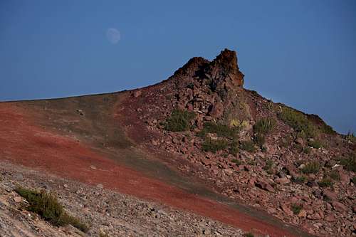 Moonrise over Green Butte
A Note On The Name
Mount Shasta, is surrounded by numerous peaks, pinnacles and spires. Most of these are found amongst the high crags in the upper reaches of the mountain. In the lower regions, five peaks have been singled out on account of their conspicuous appearance and prominence. Of these five peaks, Green Butte is the highest and most alpine. The others consist of Red Butte and Gray Butte, which are near Green Butte, Black Butte, the most recognizable of the five and Yellow Butte, the lowest and most obscure of the five. The theme of colors is obvious and in most cases, it is well deserved. However, in the case of Green Butte, the name is something of a mystery. Although there is some slight amounts of green rock around the summit, one must practically be on top of the rock to see it. From nearly any other perspective, the only green to appear on the butte is the scant krummholz trees clinging to its upper cliffs. For the most part, it consists of gray rock streaked with prominent veins of red and purple rocks. Fortunately the lack of green on Green Butte does not diminish the butte’s prominence, rugged visage and scenic qualities.
Route
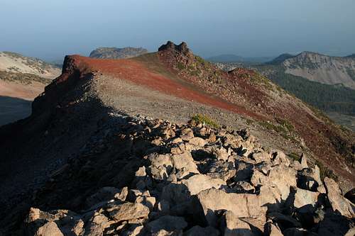 Green Butte from the route on Green Butte Ridge
There are three routes that lead to the summit of Green Butte. The easiest route is to hike the Green Butte Ridge Trail. One can also use the Horse Camp variation on this route.
Ironically, though Green Butte is most often viewed from the Old Ski Bowl, the routes originating here are much harder than those that ascend Green Butte Ridge from Bunny Flat. From the Old Ski Bowl there are two options. The first is to hike to the west on a wide, abandoned road, remnants of the skiing operation once found here. The road bends to the south in short order. From here there is a use trail that heads north. At this point it is necessary to ascend the narrow ridge that leads to Green Butte's summit. This is at least a Class IV route and has a lot of exposure. The other option is to hike the Old Ski Bowl Trail to the hidden bowl on the north side of Green Butte. Here one must climb a very steep, very loose talus slope to the summit plateau. It is also possible to climb up to Green Butte Ridge then backtrack to Point 9,365 and thence to Green Butte. This option has better climbing options to the top of the ridge, but one must then traverse the ridge.
In total, the simplest route is via the Green Butte Ridge Trail.
Map
 Green Butte and Old Ski Bowl Area
Getting There
 Green Butte from the Old Ski Bowl
On I-5, take exit 738 for central Mount Shasta. Proceed east on Lake Street, through the intersection of Lake and Mount Shasta Boulevard. The road continues east and bends to the north, reaching an intersection by Mount Shasta High School. Pass through the intersection, which becomes Everitt Memeorial Highway. Stay on the highway for 14 miles to the end of the road, which terminates at the Old Ski Bowl Trailhead.
To get to the Bunny Flat Trailhead for the Green Butte Ridge Trail, proceed only 11 miles up the Everitt Memorial Highway to Bunny Flat.
Camping
 Green Butte above the Powder Bowl
Backcountry camping is allowed within the Mount Shasta Wilderness. Overnight parking is available in the lower parking lot at the Old Ski Bowl. Dispersed camping is permitted along the Everitt Memorial Highway and is especially popular at Bunny Flat. The nearest campground is at Panther Meadows, just below the Old Ski Bowl. McBride Springs Campground is on Everitt Memorial Highway, just a few miles outside of town.
Red Tape
 Green Butte from the upper Old Ski Bowl
Green Butte is located in Shasta-Trinity National Forest. However, it falls outside of the Mount Shasta Wilderness. Nonetheless, normal wilderness rules and ethics apply. For those considering an attempt on the summit of Mount Shasta from Green Butte Ridge, Summit Passes are required for anyone climbing above 10,000 feet. A summit pass costs $20 per person, and is good for three days starting on the date of purchase. Self issue kiosks are available at the Mt. Shasta Ranger Station on Alma St. in Mt. Shasta city, the McCloud Ranger Station on Hwy 89 in McCloud and at all trailheads. Annual summit passes are $30.00 and are good for one year from the date of purchase. Annual passes are available only during regular business hours at the Mt. Shasta and McCloud Ranger Stations.
A permit is required for campfires.
Shasta-Trinity National Forest
3644 Avtech Parkway
Redding, CA 96002
(530)226-2500
Mount Shasta Ranger Station
204 West Alma
Mt. Shasta, CA 96067
(530)926-4511