Overview
![Pico do Gato (1782m), Pico Cidrao (1797m), Pico Arieiro (1816m)]() Pico do Gato, Pico Cidrao, Pico Arieiro Pico do Gato, Pico Cidrao, Pico Arieiro |
At 1816m
Pico do Arieiro is
Madeira's third highest peak after
Pico Ruivo (1861m) and
Pico das Torres (1852m). Like many island highpoints it is home to a radar installation but unlike e.g. on Lanzarote, Mallorca or Gran Canaria the restricted area does not encompass the highest point. However, a road leads to the base of the summit and you'll find a lot of visitors who didn't even have to walk for more than 100m before they reach the spot. A souvenir shop and an exhibition area add to the "civilized" feel of the mountain.
On the upside,
Pico do Arieiro can be reached on foot by two interesting routes. One - arguably one of the most beautiful routes on this planet - starts at
Achada do Texeira, close to
Pico Ruivo and negotiates the steep faces of
Pico das Torres and
Pico do Gato. Though not neccessarily a difficult route there is much exposure and some very steep sections. The route has been described
here. The second route starts at
Pico Alto above
Funchal and follows
Levada Barreiro through the
Parque Ecologico de Funchal. While this latter used to be one of the sights of the island, the forest fires of 2009 have destroyed most of it.
Apart from being popular and easy to reach,
Pico do Ariero is a typical mountain of
Madeira. The south slope may be shallow but standing on the highpoint you realize that a giant drop heads down into the valley of Ribeiro de Nogueira in the north-west. The mountain is of volcanic origin and much of it is very brittle while occasional basalt walls stand out among the debris.
Thanks to the dome of the radar station
Pico do Arieiro stands out among the summits of Madeira's central range. But it is the view from its top which is absolutely breathtaking. The towers and spires of
Pico das Torres and
Pico do Gato beautifully contrast with the rather round topped
Pico Ruivo and
Pico do Cidrao. You might even see most of the island's coasts but the central range grabs most attention.
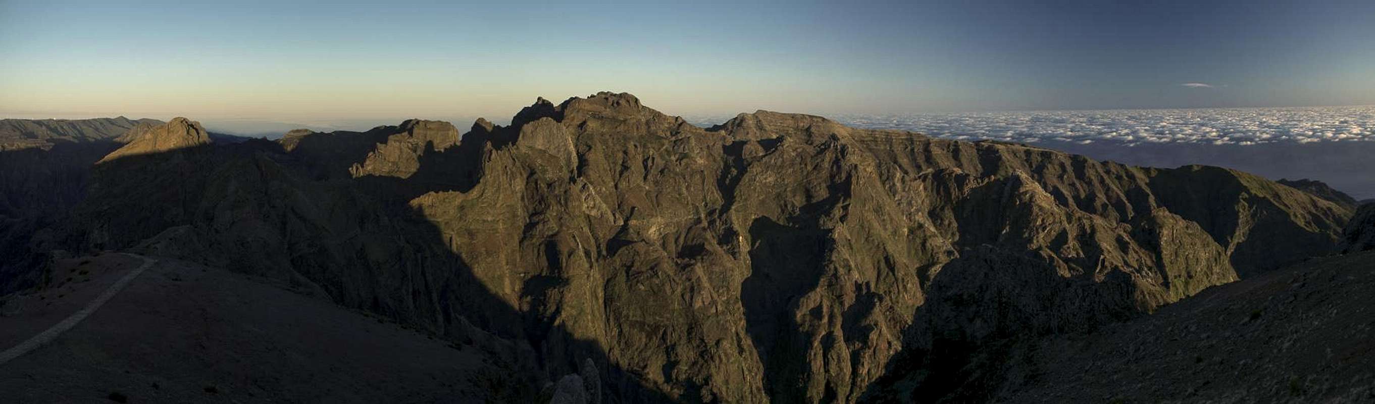
Summit Panorama
Madeira's Central Range seen in the early morning light from Pico da Arieiro |
Getting There
![Pico do Arieiro]() Pico do Arieiro seen from the south-west
Pico do Arieiro seen from the south-west
As mentioned in the overview section you can drive up to
Pico do Arieiro. T&he itinerarys, however, include the two trailheads for the hiking routes as well.
- Pico Arieiro
- From the airport take ER207 to Santo da Serra.
- Switch to ER102, direction Camacha
- At Quatro Estradas switch to ER202 to Pico do Arieiro.
- From Funchal take ER103 through Monte to Ribeiro Frio.
- At Poiso switch to ER202 to Pico do Arieiro.
- Achada do Teixeira
- Follow motorway R101 east towards its end at Machico
- Head northwest on the coastal highway R101 towards Santana.
- In Santana turn left (filling station, sign: Pico Ruivo) onto a side street which after 14km leads you to Achada do Teixeira.
- Pico Alto
- Leave motorway R101 at Funchal and drive up ER103 through Monte
- Above the village, at approximately 1100m elevation, there is a small parking lot on the left hand side of the road, which serves as trailhead for Pico Alto and Pico do Arreiro.
Red Tape
![Fisheyed summit view from...]() Fisheyed summit view from Pico do Arieiro
Fisheyed summit view from Pico do Arieiro
The area of the radar station on
Pico do Arieiro is off limits. When hiking towards
Pico Ruivo please stay on the marked trails. Theground is very brittle and should be protected. Also, take extreme care with fire. There has been a series of forest fires in the last years which destroyed much of Madeira's wonderful vegetaion, especially on the south side of the weather divide.
When to Climb
Anytime!
Madeira doesn't know any seasons so these hikes are always possible. As the island is located in the trade wind zone (see below) there might be clouds on the summit.
Pico do Arrieiro is located to the south of the weather divide and thus a bit safer than the other mountains of
Madeira.
Accomodation
![Looking down on Funchal]() Looking down on Funchal from the trailhead at Pico Alto
Looking down on Funchal from the trailhead at Pico Alto
You can find a lot of hotel rooms and apartments on
Madeira. Either visit the next travel office or do an internet search. The island is small, all trailheads can be reached by car in an hour from almost anywhere on the island. Most accomodation can be found in the south of the island near
Funchal and
Camara de Lobos.
Weather Conditions
![Arieiro Sunrise]() Arieiro Sunrise
Arieiro Sunrise
Weather conditions cannot be predicted accurately. Madeira is located in the trade wind zone. You almost always encounter northeastern winds which carry a lot of humid air. Being forced to climb to higher altitudes this moisture condenses into clouds. This in return means that most of the time the northern part of the island is covered in clouds from altitudes of 1000m through 2000m.
The mountains themselves - being of the same altitude -finally stop the clouds so that on their southeastern slopes the clouds "run out". Look at the pictures - it looks like the clouds creeping over the weather divide. Boca da Encumeada - being some 500m lower than the surrounding summits - is a gateway for the clouds from north to south. Thus it very often is covered in mist. Unfortunately all of the major peaks of Madeira lie around the weather divide, sometimes within, sometimes just out of the clouds.
The following table shows weather data for Funchal on the southern coast. Be careful with these data if you want to climb the summits...
| Month | Jan | Feb | Mar | Apr | May | Jun | Jul | Aug | Sep | Oct | Nov | Dec |
| Avg. day temp.[°C / °F] | 16 / 61 | 16 / 61 | 17 / 63 | 20 / 68 | 24 / 75 | 27 / 81 | 29 / 84 | 29 / 84 | 27 / 81 | 23 / 73 | 21 / 70 | 17 / 63 |
| Avg. night temp.[°C / °F] | 9 / 48 | 9 / 48 | 10 / 50 | 12 / 54 | 15 / 59 | 19 / 66 | 21 / 70 | 22 / 72 | 19 / 66 | 16 / 61 | 13 / 55 | 11 / 52 |
| Water temp.[°C / °F] | 16 / 61 | 15 / 59 | 16 / 61 | 16 / 61 | 19 / 66 | 22 / 72 | 24 / 75 | 25 / 77 | 24 / 75 | 23 / 73 | 20 / 68 | 17 / 63 |
| Rainy days | 12 | 7 | 8 | 4 | 2 | 1 | 0 | 0 | 2 | 6 | 6 | 10 |
Maps & Books
Maps
- Madeira
Tour & Trail Map
Discovery Walking Guides
1:40000
ISBN: 190494678X
Books
My recommendation is a guidebook by Rother Verlag, available in several languages. The book is an excellent hiking guide covering all the interesting areas of the island. Since it comes with small maps for each excursion it might even be used without a map to support them.
- Madeira
Rolf Götz
Rother Verlag
ISBN 978-3-7633-4811-4 (English)
ISBN 978-3-7633-4274-7 (German)
ISBN 978-3-7633-4910-4 (French)
ISBN 978-3-7633-4297-6 (Portugese)
ISBN 978-3-7633-4708-7 (Spanish)

 16381 Hits
 81.18% Score
 13 Votes
 Pico do Gato, Pico Cidrao, Pico Arieiro


 Pico do Arieiro seen from the south-west
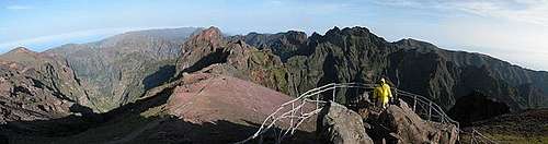 Fisheyed summit view from Pico do Arieiro
 Looking down on Funchal from the trailhead at Pico Alto
 Arieiro Sunrise