
-
 13685 Hits
-
 87.31% Score
-
 24 Votes
|
|
Mountain/Rock |
|---|---|
|
|
61.91548°N / 9.85047°E |
|
|
Innlandet |
|
|
Hiking, Mountaineering, Scrambling |
|
|
Summer |
|
|
7146 ft / 2178 m |
|
|
Overview
Geographical classification: The Scandes > Rondane > Rondeslottet
Rondeslottet/Rondslottet 2178 m
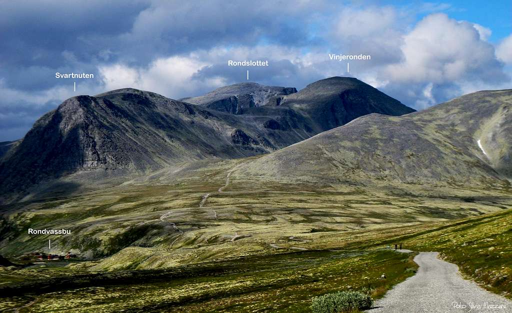
The Rondane National Park, in the Norwegian counties of Oppland and Hedmark, includes the namesake mountain range, counting nine peaks exceeding the altitude of 2000 meters above sea level, a magical threshold in Norway! In fact there are no peaks reaching 3000 meters of altitude in the whole Scandinavia, with the highest peak being the Galdhøpiggen (Jotunheimen) getting the altitude of 2469 m. These nine summits are divided in three groups, being situated within three different areas of the Rondane park. The Northernmost group includes Høgronden 2117 m, Midtronden 2060 m and Digerronden 2016 m; the West side of Rondane includes Trolltinden 2018 m, Storsmeden 2016 m and Veslesmeden 2015 m. The East group includes the highest summits, with Rondslottet 2178 m, Storronden 2138 m and Vinjeronden 2044 m. Therefore Rondslottet is the highest mountain in the Rondane National Park.
Rondane is the plural of the word "rond"; as previous told many mountains here have the ending -ronden and this is the singular of the same word, probably coming from the original place-name of the long and narrow lake Rondvatnet, located at foot of the peaks.


From Rondvassbu, Rondslottet is always climbed after having summited the nearby Vinjeronden, a compulsory stage for those leaving the Rondvassbu Hut; sometimes some scramblers (a long day!) also climb on the same trip the third mountain of the trio, the Storronden. To summit the three consider a long day!
Getting There
Road access
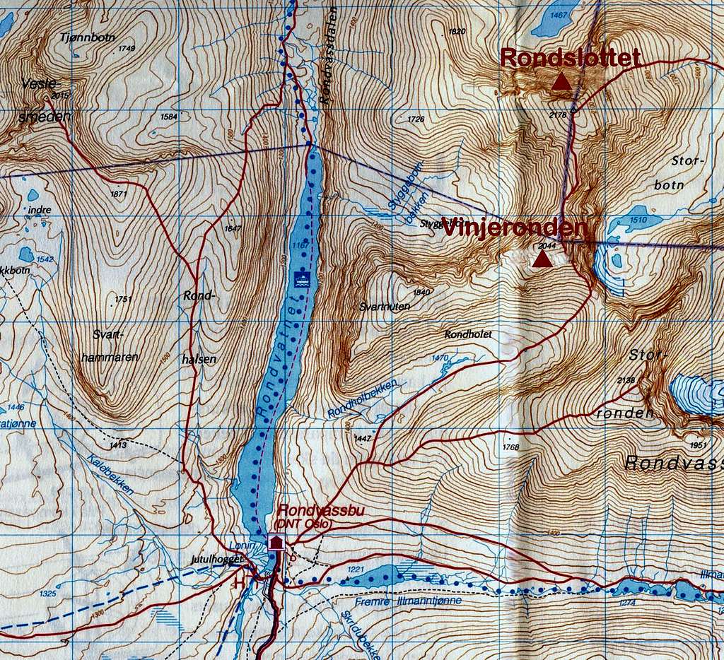
From Otta, the nearest village, follow the highway E6 eastward and 800 m south of the E6/RV15 junction take on the left the minor road to Mysuseter and Rondane. Once getting to a small hamlet, turn to left on a toll road leading to the parking lot of Spranghaugen 1085 m (Spranghet) at the boundary of Rondane National Park (at about 18 km from Otta).

Here you can rent a MB (you return the bike at the Rondvassbu Hut) or alternatively walk Northeast towards Rondvassbu Hut along the private track for about 6 km. (about 1 hour from Spranghaugen). Rondvassbu Hut is the best starting point to climb Rondslottet and the neighboring Vinjeronden and Storronden.


Rondeslottet from Rondvassbu Hut
Rondeslottet from Rondvassbu Hut route report
Summit altitude: 2178 m
Difficulty: easy scramble (YDS Class II)
Vertical gain: 1000 m
Starting point: Spranghaugen
A spectacular itinerary starting from the beautiful lake Rondvassbu, where it's situated the namesake hut, crossing the wild Rondholet valley, then climbing up Vinjeronden and Rondeslottet, the highest summit in Rondane. During the descent, once back to the saddle between Vinjeronden and Storronden, you may have the option to climb up also the third summit belonging to the group, the Storronden, on a steep off-trail


Route report
Just behind the buildings of the Rondvassbu Hut, a well-marked trail starts to the right, overcoming the steep slope (Rondslottet-Storronden signposts), then continues on more gentle terrain (cairns and signposts), reaching soon a fork, where on the right it starts the route to Storronden. The route to Rondeslottet continues straight and after a little descent enters Rondholet and heads to NE - more or less on level - across the broad valley with some tiny ponds, running in the middle of the extended plain towards the head of the valley.

Once getting the head of Rondholet, the trail rises steeply to reach a large saddle between Vinjeronden on the left and Storronden on the right, where it opens a spectacular view on the wild wall of Storronden and the Storbotn Valley on the opposite side.


From the saddle head to NW (to the left) and scramble up on rocky ground, seeming more difficult than it really is, along the steep granite boulders of Vinjeronden South-East ridge, taking some other impressive glimpses into Storbotn and reaching the wide plateau of the Vinjeronden summit, marked by a cairn. From the top it appears the first view of Rondslottet, well visible about 1.5 km to the North, connected with Vinjeronden by a long ridge.


We head towards the side opposite to our ascent (North), downclimbing steeply on big boulders for about 100 meters and getting the beautiful saddle between Vinjeronden and Rondslottet, where snow remains until late summer. From the saddle climb up the Rondeslottet South Ridge, steep in the beginning, with some easy rocky moves, choosing the most convenient passages.

After a flat section, the route climbs up the final steep 100 meters to the Rondeslottet summit, which appears surprisingly broad, marked by a huge cairn. The view is breathtaking.
Descent - Reversing the same route
Red Tape

No particulary restrictions. The route is situated inside the superb Rondane National Park, established in 1962, the oldest national park in Norway. The park was extended in 2003, and now covers an area of 963 km2 between Oppland and Hedmark counties. The park includes 9 peaks above 2.000 metres, with the highest being Rondeslottet at an altitude of 2.178 m. Rondane lies just to the East of Gudbrandsdal and nearby Dovre and Jotunheimen, two other important mountain areas.
When to Climb
Summer and early Autumn are the best period
Nature and climate
Rondane is one of the few places in Scandinavia and Europe where the wild reindeer lives. There is a certain shortage of plants species in the region, on the contrary Rondane is very rich in lichens, so much that it's possible to say that Rondane is the kingdom of lichen. This plant forms the characteristic lichen mats that serve as food for the reindeer during the winter months. Rondane has a reputation for relatively dry weather in summer, especially if compared to the mountain ranges located nearby.
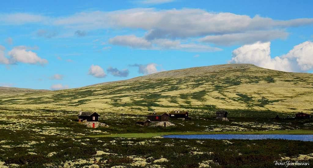
Hut

- Rondvassbu 1173 m - DNT Oslo
Situation: shore of Rondsvatnet
Owner: DNT Oslo email: rondvassbu@turistforeningen.no
Meteo
Guidebooks and maps


-Guidebooks
"Walks and Scrambles in Norway" by Anthony Dyer, John Baddeley, Ian H. Robertson - Hiking, Scrambling and Mountaineering in Norway, an English guidebook covering Jotuheimen and several other areas in the Scandes - Ripping Yarns 2006
"Norway South" - Bernhard Pollmann
- Map "Rondane Nord" - Turkart 1:50.000