
-
 102664 Hits
-
 99.17% Score
-
 100 Votes
|
|
Mountain/Rock |
|---|---|
|
|
38.06060°N / 107.51°W |
|
|
Hinsdale and Ouray |
|
|
Scrambling, Skiing |
|
|
Spring, Summer, Fall |
|
|
14015 ft / 4272 m |
|
|
Under New Management
Hi everyone, the previous owner of this page has decided to move on from Summitpost and is in the process of transferring pages to new owners. As such, I have agreed to adopt this page.
I took over on March 9, 2012, along with several other pages. This page is completely new and reformatted. I also replaced the Southeast Ridge route, which had been deleted. I hope you find the new pages as informative and useful as the old ones, please feel free to leave any comments you have.
Happy hiking!
"Chicago Transplant"
Overview
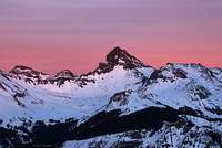
Colorado’s Wetterhorn Peak was named for its Swiss counterpart in the Bernese Alps by members of the 1874 Hayden Survey, who saw similarities between the two peaks’ summit pyramids. Where the Swiss peak towers above Grindelwald and graces many a postcard, the Colorado version remains more hidden from view, best viewed from neighboring peaks, or from Colorado State Route 149 from near Slumgullion Pass. Colorado’s Wetterhorn also enjoys its status as one of the states “Fourteeners”, peaks above 14,000 feet in elevation, of which the state has more than 50, where the Swiss Peak “only” reaches 12,000 feet. Wetterhorn is a German word which translates to “Weather Peak”.
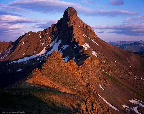
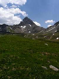
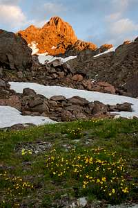
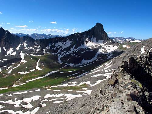
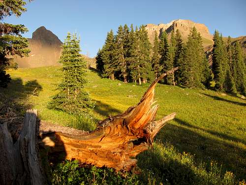
Located in the San Juan Mountains and standing at 14,015 feet above sea level, Wetterhorn is the 49th highest peak in Colorado. While it is less than 3 miles away from its “parent” Uncompahgre Peak, the low connecting saddle gives it 1635 feet of clean prominence and dominating views from its summit. It is a distinct peak, easily recognizable from neighboring summits by an elegant summit pyramid which has four ridges emanating from it. The seldom seen north face, provides a nearly vertical 800 foot high wall which is best viewed from neighboring summits such as The Heisshorn. During the summer the surrounding basins fill with colorful wildflowers, which provide a beautiful foreground for the peak’s rugged ridges.
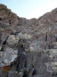
Among the fourteeners, Wetterhorn is one of the harder, requiring 3rd class scrambling by its easiest route. The scrambling is on good rock without too much exposure, and is a great “step up” peak for people as they move from the “walk up” fourteeners to the harder ones. Between its height, prominence, views, and difficulty, Wetterhorn is one of the most rewarding fourteeners to reach the summit of.


Getting There
Wetterhorn Peak is in the San Juan Mountains of southwestern Colorado about 12 miles from the hamlet of Lake City. To reach this peak, the most practical trailhead is the Matterhorn Creek trailhead. From Colorado State Route 149 in Lake City, turn west on Second Avenue following the signs for Engineer Pass, part of the Alpine Loop Scenic Byway. The Alpine Loop is Colorado’s only 4WD Scenic Byway, but you can come close to this trailhead without needing a 4WD vehicle. Follow Second Avenue until it “T”s at Bluff Street and turn left, the road becomes the Henson Creek Road, and it is graded gravel. Follow it for 9.2 miles to the old Capitol City site and the North Henson Creek Road. Lower clearance vehicles or 2WD vehicles should park here. Turn right here and follow the now rougher and steeper road for 2 miles to Matterhorn Creek, and a signed turnoff. Most standard SUVs or higher clearance cars like an Outback can get to this point, one of the rocky challenges is early, so if you have any doubts you can make it, park at the bottom of the road and walk 100-200 yards to check it out.
After two miles you will reach the turn for Matterhorn Creek (signed) at 10,400'. There are a few campsites here. If you have a high clearance 4x4 vehicle, turn up the steep and rocky Matterhorn Creek Road and follow it for .7 miles to a parking area in front of a Forest Service gate at 10,720'. This is the start of the hiking trail. This portion of road hikes quick and most people just park at 10,400 as it doesn't add much to the day and saves your vehicle.
Alternate trail access can be reached from the Nellie Creek road, but it really only makes sense to use that approach route if combining your ascent with Uncompahgre Peak. You can also reach this trailhead from Silverton and Ouray via the 4WD Engineer Pass Road, which will require 4WD SUV, most stock vehicles will do okay, but you want a “real” SUV, and not a “crossover” due to the rocky and steep nature of the road. Even with a stock SUV, you will need careful driving as the west side can be quite a serious road for the initiated!
Routes Overview
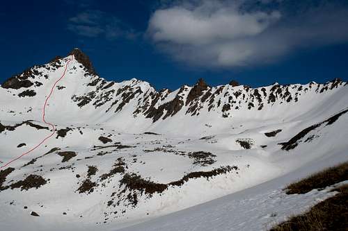
Southeast Ridge
Click Here
8.25 miles and 3600' round trip from the 10,400' parking area
Class 1 trail to an increasingly difficult ridge with some class 3 scrambling before a 150' class 3 summit pitch.
The early trail is easy to follow to the ridge crest, from there some route finding is required as you navigate around some towers, over a class 3 rib, and up a class 3 gully. You cross the ridge to bypass "Ships Prow", then cross back at a notch and engage the final 150' of class 3 scrambling to reach the summit.


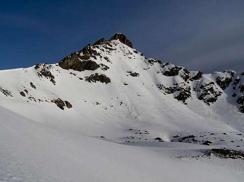
East Face
Click Here
8 miles and 3600' round trip from the 2WD parking area
Class 1 trail to the base of a large snow slope that approaches 50 degrees. Finish with the same 150' of class 3 as the southeast ridge route. This route is often used as a ski descent, for which it is rated D13.
The San Juan Range
Wetterhorn Peak resides in the northern San Juan mountains of Colorado. The San Juan range is Colorado's largest range by square miles, and extends throughout southwestern Colorado. The character of this range is as varied as the miles is spans, and it is one of the finest mountain ranges in the Rockies. Some of the most remote high country in Colorado is in the San Juan mountains, however, its rich mining history leaves many areas easily accessible by 4x4 vehicles on old mining roads.
There are 14 fourteeners (12 of which are "ranked" - having more than 300' of prominence), or which Wetterhorn is one of them. There are an additional 16 thirteeners in the range that are part of the Highest 100, for a total of 28 of the states highest 100 peaks. The most of any range.
Wetterhorn is on the edges of the sub-range known as the Cimarron. A volcanic area, some of the peaks rugged beauty is marred by some of the loosest rock in Colorado. Luckily the rock on Wetterhorn is generally solid, allowing you a reasonably safe vantage point to view its more rugged and loose neighbors.
Red Tape
Wetterhorn peak is located within the Uncompahgre Wilderness Area and is subject to the rules and regulations thereof. These regulations include no motorized or mechanized vehicles (including mountain bikes), limitations on group size, where you can camp, and feed for stock. Check here for additional information.
Camping is not allowed along the Henson Creek Road except in limited designated sites.
When To Climb
Generally in winter the road is only open to the Nellie Creek Road, which is 4 miles below Capitol City. As such, winter routes are long, and prone to avalanches. For those reasons, this peak is recommended for when the road is open. I have been able to drive to the Matterhorn Creek turnoff by Memorial Day weekend in the past, some times you can get to Capitol City by April. It’s a tough call when the roads will be accessible, so if you have to travel a long way, you may want to wait until June.
For the standard Southwest Ridge route, I would recommend Late June through September. Early fall snows could add icy conditions to the summit pitch and spring snow lingers in the summit pitch and can also cause the route to be icy. The East Face route is best as a snow climb and May/June are good times for this route depending on conditions. It is also the preferred route for people looking to ski the peak, however the route is steep and recommended for expert backcountry skiers only.
As with all high peaks in Colorado, Wetterhorn is threatened by afternoon thunderstorms and it is recommended for summer ascents that people be off of summits by noon so as to be back below treeline before the storms come. Noon is just a guideline of course, and you will have to judge turnaround times for yourself based on weather conditions and your ability to retreat quickly. The 3rd class summit pitch is not a place to be stuck in a storm!
Camping
As mentioned under the “Red Tape” section, camping is only allowed in limited designated sites along the Henson Creek Road. There are places to camp near the North Henson Road/ Matterhorn Creek Road split, and also some spots at the end of the Matterhorn Creek Road. For backcountry camping, hike along the trail and there are some nice spots near an 11,200' meadow where the climbing route take a turn and the Matterhorn Creek Trail goes straight.
Topographic Map
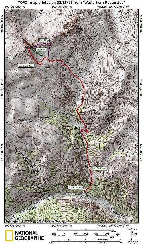
Click to Enlarge
Acknowlegements
Special thanks to the original page author Aaron Johnson. Additional thanks to the book "Colorado's Fourteeners from Hikes to Climbs" by Gerry Roach and the website 14ers.com. Statistical information is from the website Lists of John. Also, thanks to all of YOU for your great photographs, routes, and trip reports! Keep them coming!