
|
|
Mountain/Rock |
|---|---|
|
|
2.764°S / 35.91400°E |
|
|
Hiking |
|
|
9442 ft / 2878 m |
|
|
Overview
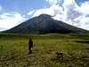
Ol'Doinyo Lengai is the "Mountain of God" for the Massai. On its top the god of the tribe has its home. This beautiful stratovolcano lies on the Rift Valley, a cliff-like scrap running from Djibouti to Mosambique. Ol'Doinyo Lengai is one of the most active volcanos of this fault - and moreover he is the only active volcano of the world with carbonatited lava.The volcano is rarely visited, because you need two days from the next airport to reach him. Maybe one or two groups of tourists/scientists climb it a day.
The climb is not that hard - always about 45° slopes - near the top you have to use your hands because of ash and lava channels.
 |  |  |  |  |
Getting There
From Kilimanjaro Int. Airport you need about 1 hour to the town of Arusha. Take the road to the west and after 116 km you will reach Mto-Wa-Mbu (River of Mosquitos). Take the dusty road to the north (to Lake Natron, only 4x4, not during wet season) and after 6 hours you will arrive at OlDoinyo Base Camp. From there it's only half an hour to the trailhead at the slopes of Lengai.The best way to visit the crater highlands inclusing Lengai is to organise a walking safari to the crater highlands: walk with Masai guides and donkeys through the highlands, pass Lengai and climb it!
It will take 6-9 days, you will encounter all kinds of animals and small unspoilt Masai villages.
See Kilimanjarotrips.com for prices etc. (also for Kilimanjaro trips ;-)
 |
Red Tape
There are no permits required. You only need a visa for Tanzania, and there are entrace fees for the Ngorongoro Conservation Area(NCA). But if you only climb OlDoinyo you won't enter this area.If you do the walking safari as described above you will have to pay the fees (included in organised trips).
When To Climb
You can climb the volcano the whole year round, only in the wet seasons (march to may, october to december) the roads are in bad conditions.Be sure to bring enough water on teh way up as it's a barren and hot environment and many have become dehydrated during the ascent or descent!
 |
Camping
Camping is allowed everywhere (only forbidden in the NCA). But think about it - the ground consists only of sand and rocks and the wind is strong. You can put up your tent on the ground of the base camp.Miscellaneous Info
External Links
- Kilimanjaro and Lengai walking safari trips
Check out www.kilimanjarotrips.com, part of www.7summits.com; here you can book 6-9 days walking safari's through the crater highlands, including a climb of Lengai!
- Global Volcanism Program
By the National Museum of Natural History, Smithsonian Institution
- Ol Doinyo Lengai Climbing & Trekking
Oldonyo Lengai Hiking,Walking Safaris Tanzania,Lengai Hiking,Mountain of God Hiking,Trekking Oldonyo Lengai,Hike,Trek Oldoinyo Lengai Hills,Ndoinyo Lengai Mountains
- Oldonyo Lengai Hiking,Walking Safaris Tanzania,Lengai Hiking,Mountain of God Hiking,Trekking Oldonyo Lengai,Hike,Trek Oldoinyo Lengai Hills,Ndoinyo Lengai Mountains
African Sermon Safaris offers exciting African safari holidays,Kenya safaris,African wildlife tours and travel,Tanzania safaris,gorilla safaris,Uganda safaris,gorilla trekking,beach holidays,adventure camping safaris and tours,Kenya and Tanzania safari holidays,incentive tours,beach safaris,walking safaris
Swiss volcano information page about Lengai
7summits - Nov 12, 2001 7:16 am - Hasn't voted
Untitled CommentHi there,
we organise walking safari's to the crater highlands: walk with Masai guides and donkeys through the highlands, pass Lengai and climb it!
See www.kilimanjaro-trips.com for prices etc. (also for Kilimanjaro trips ;-)
Best regards,
harry
www.7summits.com
Baarb - Jul 31, 2006 6:29 am - Hasn't voted
It's getting hot in here....The viscosity of this lava means that you cannot outrun it. You may find yourself in the middle of a lake of the stuff before you realising it. Make sure whoever you go with really knows what they're doing or you could find yourself somewhat melted below the knees. And stay away from pillars, you don't really want them spurting on you. Enjoy! :D
Bergrot - Feb 12, 2007 5:07 pm - Hasn't voted
Volcano activity...videos, panoramas, pictures and much more. Probably the best webpage on Ol Doinyo Lengai's volcanic activity: www.swisseduc.ch/stromboli/perm/lengai/index-en.html Please add this to the link list. It's worth it. Thanks
7summits - Feb 18, 2007 8:39 pm - Hasn't voted
Re: Volcano activity...Thanks for the link, I have added it, very useful!
fubar7500 - Jul 24, 2011 12:27 pm - Hasn't voted
Elevation ?Hi, Thanks for maintaining your page. I am just wondering, what is the correct elevation of this volcano. After the last eruption many sources (travel guides, wikis) list the elevation of 2,980m (9,777 ft). Dont know what is right :-)
7summits - Aug 21, 2011 9:23 am - Hasn't voted
Re: Elevation ?Hi Fubar, I have not seen an accurate remeasurement. Google Maps also still gives 2900m, it seems impossible that an eruption added 100m, but you never know :)