
-
 61553 Hits
-
 89.71% Score
-
 31 Votes
|
|
Mountain/Rock |
|---|---|
|
|
47.41773°N / 121.48152°W |
|
|
Download GPX » View Route on Map |
|
|
King |
|
|
5629 ft / 1716 m |
|
|
Overview
The South Face Of Granite, April 2009
Trails: 1007, 1016
4 miles one way
Average hiking time up: 3 hours
Trailhead Elevation: 1800 ft
Elevation Gain: 3800 ft
Region: North Bend Ranger District
Maps: USGS Snoqualmie Pass
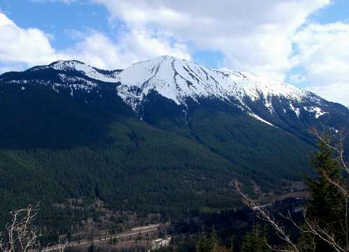
Granite Mountain is becoming one of the most popular hikes on the I-90 corridor. The incline and elevation gain makes it an ideal training hike for larger peaks like Baker or Rainier. From the trail head, follow Pratt Lake Trail #1007 which ascends through the woods gradually climbing for about a mile until you cross several small creeks and it meets with the Granite Mountain Trail, that goes up to the right (#1016).
The trail starts with steep switchbacks through the woods coming out onto the open slopes at times. In about a mile and a half it crosses a creek, enters open slope and continues up to the ridge for another mile. In the winter time the open slope is where you can ascend the gully to save mileage but gain some serious vertical feet. This is also the glissade route that is preferred in the winter months. The Lookout Tower can be seen from this point.
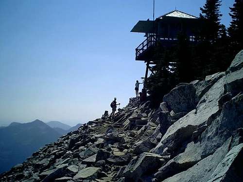
The next 1/2 mile to the lookout goes past a rocky ridge. During the winter, with enough snow, it's possible to follow this talus ridge slope, but during the summer, it may be better to stay on the trail. Exercise caution if you take the ridge route. Magnificent views of the surrounding mountains and valley open up from the summit. The Lookout Tower is not open to the public, and I have never seen anyone stationed there. Be careful in the winter months as cornices hang over quite a bit towards the north. The last major forest fire to take place on Granite Mountain was in 1865. Many large dead snags are still visible even from Interstate 90.
 |
 |
 |
 |
 |
Route Map
Getting There
Latitude 47.418ºN
Longitude 121.480ºW
From Seattle take I-90 East to Exit 47. Turn left at the Stop, in about 0.1 mile turn left again. Trailhead is in 0.3 mile on the right side.
There is a large parking area, but no campsites, or running water, but a public outhouse is available.
Red Tape
Permits: Northwest Forest Pass is required at trailhead for parking
When To Climb
Season: June - October
Avalanche conditions make this climb a dangerous one during the winter months. Although the route is considerable shortened in the winter due to the terrain making the avalanche chute very accessible, there have been many accidents in the past. The chute is considerably steeper than the trail, gaining almost 2000 vertical feet in less than a mile. For winter ascents of the avalanche chute, be sure to bring your axe and check conditions.
 |
 |
 |
 |
 |
 |
Camping
Officially, no camping allowed.
Conditions
North Bend Ranger Station
(425) 888-1421
NOAA daily weather prediction for North Bend.
bighurtbob - Jan 30, 2003 1:38 pm - Hasn't voted
Untitled CommentThe lookout is used in summer months by researchers from Huxley College conducting studies on clouds (checking the pH) and its effect on lichens.
dicey - Nov 3, 2012 3:21 pm - Hasn't voted
Trail HeadThere is currently, and always has been, a bathroom at this trail head, btw.
gimpilator - Nov 14, 2012 4:19 pm - Hasn't voted
Re: Trail HeadThanks for the correction!