

-
 40454 Hits
-
 86.84% Score
-
 23 Votes
|
|
Mountain/Rock |
|---|---|
|
|
34.12440°N / 116.8936°W |
|
|
Hiking, Mountaineering |
|
|
Spring, Summer, Fall, Winter |
|
|
10840 ft / 3304 m |
|
|
Overview
Anderson Peak is located in the heart of the San Gorgonio Wilderness Area in the San Bernardino Mountains in Southern California. At 10,840', it is the fifth highest peak in Southern California south of the Sierra Nevada, and one of seventeen peaks in the SGWA with an elevation of over 10,000'. It is the third peak, in a series of peaks, that lie west to east on the San Bernardino crest/ridge, starting with San Bernardino Peak at the western end and ending with Alto Diablo at the eastern end, before the ridge takes a dogleg southeast to continue on with Charlton Peak, Little Charlton, Jepson Peak, and Mount San Gorgonio, the highest point in Southern California.
Many hikers will bag this peak as part of the "Nine Peak Traverse," an alpine hike or backpack that can be, depending on which trailheads are used, over 30 miles in length with over 10,000' of gain. The Nine Peak Traverse is normally done as a 2-3 day backpack, but can also be done as a very strenuous day hike.
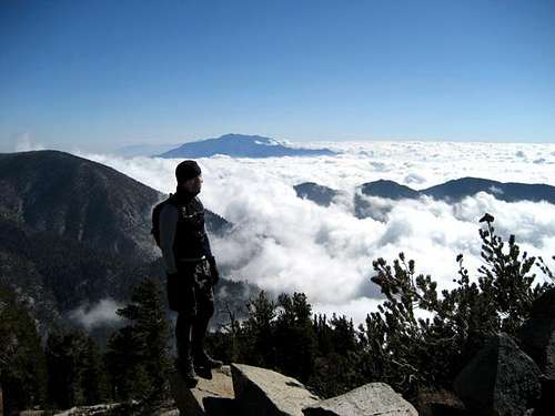
Unlike most of the other peaks on the crest, the views from the summit are less than ideal due to the heavy forestation on the summit. Walking around the summit does offer good views of various parts of the SGWA (as well as the Yucaipa Ridge and Big Bear Lake), but the trees prohibit an all-encompassing vista. Shields Peak, a scant mile and a half away, for example, offers a much better view despite it being shorter.
To get a better view of the Yucaipa Ridge as well as San Jacinto and the rest of Southern California, it is possible to walk down from the summit to the south. This allows for a more unobstructed view to the south, but most folks never make it this far.
 Just below (south of) Anderson Peak's summit.
Hiking Routes
- Anderson Peak via the South Fork Trail (TH 6,880') -
- From Redlands, head east on CA-38, approximately 26 miles to Jenks Lake Road, on the right. Turn right (south).
- Continue approximately 2.5 miles to the signed South Fork Trailhead parking lot on the left.
- Head south on the South Fork Trail (1E04) to South Fork Meadows where the Dollar Lake Trail forks right.
- Bear right (southwest) and take the Dollar Lake Trail to Dollar Lake Saddle (9,960') where there is a major trail junction.
- Bear right, heading directly west along the San Bernardino Peak Divide Trail (1W07).
- Hike west (right) on 1W07 for approximately 2 1/2 miles, staying with the trail until you reach a junction where a trail goes down on the right towards Trail Fork Springs.
- Keep left and after about 200', there will be a faint use trail on the left. Leave the San Bernardino Peak Trail here and hike southwest up to the summit.
-
Anderson Peak via the Forsee Creek Trail (TH 6,720') -
- From Redlands, head east on CA-38, approximately 26 miles to Jenks Lake Road, on the right. Turn right (south).
- Drive 0.3 mile to a fork at a sign "Forsee Creek Trail". Turn right (southwest).
- Keep left at an immediate fork. Drive 0.5 mile farther to a parking lot at a sign "Forsee Creek Trail".
- From the parking area (6720'), hike up the Forsee Creek Trail (1E06).
- After approximately 1/4 mile you will pass a Wilderness Area sign. About 200 yards farther the trail forks. Go left here, heading towards "Jackstraw Springs".
- Proceed 5 1/2 miles to Trail Fork Springs at 10,400'.
- Leave the trail here for some easy cross-country, hiking directly south up the fairly gentle slope.
- Cross the San Bernardino Peak Trail and continue heading straight south up to the summit.
-
Anderson Peak via the San Bernardino Peak Divide Trail (TH 5,960')
- From Redlands, head east on CA-38, approximately 20 miles to Angelus Oaks.
- Here, turn right (east) at the signed entrance road to the fire station. Turn left immediately and go 0.1 mile to a fork signed "Trail". Turn right, then immediately half right again.
- Continue 0.3 mile to the trailhead.
- From the parking area (5,960'), hike up the San Bernardino Peak Divide Trail (1W07).
- Approximately 9 miles in, a use trail heads off to the south (right) for a short trip up to San Bernardino Peak. Stay straight.
- Approximately 10 miles in, a use trail heads off to the south (right) for a short trip up to San Bernardino East Peak. Stay straight.
- Approximately 11 miles in, you will first pass the junction with the MomyerTrail (on your right / south), and then the junction with the Forsee Creek Trail (on your left / north).
- Immediately after the junction with the Forsee Creek Trail, a faint use trail will head off cross-country to your right (southwest). Follow up to the summit.
-
Anderson Peak via the Momyer Trail (TH 5,520')
- From Redlands, head east on CA-38 approximately 13 miles to Valley of the Falls Road. Turn right.
- Drive 2.9 miles to a parking area on the left. Park here.
- From the parking area (5520'), hike up the Momyer Creek Trail (1E06) toits junction with the San Bernardino Peak Divide Trail (1W07).
- Turnright and follow the trail east about 1/4 mile to a fork heading to your left (north). This is the junction with the Forsee Creek Trail.
- Immediately past the fork, leave thetrail, and follow a faint use trail cross-country to your right (southwest). Follow up to summit.
Red Tape
Anderson Peak is located in the San Gorgonio Wilderness Area, and a Wilderness Permit is needed to enter the wilderness area, either to day hike or backpack/camp. Wilderness Permits are free, but are limited by quota. One may apply for a permit up to 90 days in advance (link below).
Certain trail heads approaching the SGWA require a National Forest Adventure Pass. As of Feb 21st, 2013, per the Supervisor for the Mill Creek Ranger Station, two of the four trail heads / routes specifically mentioned in this page no longer require a NFAP: Forsee Creek and Lost Creek. The South Fork trail does still require an Adventure Pass. The rule is "Restroom plus 6 other amenities" to require the pass:
Forsee, San Bernardino Peak Divide, Lost Creek, Aspen Grove, and Fish Creek Trails no longer require a pass, and
Vivian Creek, Momyer, and South Fork Trails do require a pass.
A more comprehensive list of Adventure Pass requirement for Southern California area trails, camps, and facilities is available here.
NFAP are available at most major outdoor and sporting goods stores at the cost of either $5 for one day, or $30 annually.
Please remember that, as noted above, while the National Forest Adventure Pass is not needed for certain trails, the Wilderness Permit is still needed to access the wilderness area from any of the trailheads.
When To Climb
Year-round. Summertime is the most popular but this can be a great hike in the winter as well. Snowshoes or crampons may be needed depending on the snowpack.
Camping
Camping is allowed. There are several campgrounds in and around the area. Camping on the mountain or anywhere within the San Gorgonio Wilderness requires a permit that can be obtained from the Mill Creek Ranger Station at 34701 Mill Creek Road in Mentone. You can also request a permit via fax (909) 794-1125.
External Links
San Gorgonio Wilderness Area:
Mill Creek Work Center:
Developed campground information:
Additional trailhead, mileage, trail camps, and elevation data can be viewed here:
http://www.sgwa.org/trails2.htm
Information on wilderness permit applications can be located here:
http://www.sgwa.org/permit.htm
Information on Adventure Pass requirements for various trailheads and trail camps in the So Cal area can be accessed here:
http://www.fs.usda.gov/detailfull/r5/home/?cid=stelprdb5404142&width=full#asbnf