
-
 50122 Hits
-
 92.32% Score
-
 38 Votes
|
|
Mountain/Rock |
|---|---|
|
|
39.02110°N / 106.4192°W |
|
|
Hiking |
|
|
Spring, Summer, Fall, Winter |
|
|
13933 ft / 4247 m |
|
|
Mount Hope Overview

Please Note: The Overview text was provided by SP member, miztflip. The Mount Hope page has recently transfered ownership and I have primarily updated the route information, below.
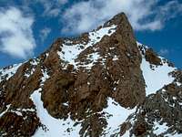
Mount Hope (13,933-ft) rests within the backbone of the Colorado Continental Divide, the Sawatch Range. This complex range stretches nearly 100 miles north and south, starting at Tennessee Pass and ending at the Marshall Pass area. The Sawatch is home to 15 fourteeners and 14 centennial thirteeners; no other Colorado mountain range contains as many peaks above 13,800 ft. When planning a hike of the Central Sawatch, there are a few things you can count on, long approaches, plenty of vertical, and endless class 2 hiking. Sticking to the normal Sawatch mountaineering theme, Mount Hope has very steep surrounding slopes and gentle, broad ridges leading to its elusive summit.
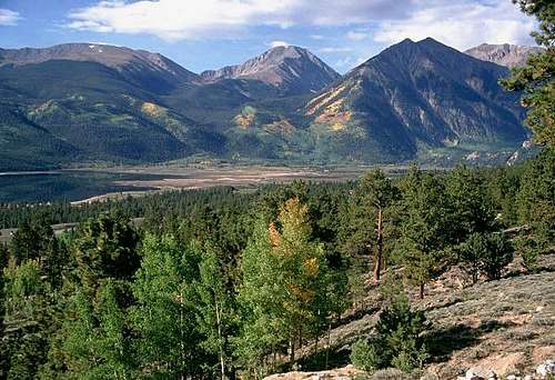
Mount Hope (13,933-ft) is another in a long line of towering Colorado Sawatch Mountains. Similar in configuration to its neighboring fourteener La Plata Peak (14,336 ft.), this immense mountain only typifies it’s grand surroundings. In my opinion there is one word that best describes these mountains that surround this area “expansive.” In addition to the mountains listed above the Twin Lakes area is home to Mount Elbert, Mount Massive, Mount Oklahoma, French Mountain, Casco Peak, Rinker Peak, the Belford Group and many other notable highpoints.
The view of Mount Hope from the Twin Lakes Recreational Area is a photographers dream. Teaming up with another stately mountain; Rinker Peak, these two mountains form the impressive skyline that towers over Twin Lakes.
In contrast to its neighboring fourteeners, Mt. Hope will deliver plenty of solitude to go along with a refreshing short standard route. The standard East Ridge Route starts at the Sheep Gulch TH (9,860-ft) and ascends the wonderful Colorado Trail up through a beautiful strand of aspens and continues to Hope Pass (12,540-ft.) Don’t be fooled by the short route, you still get 4,073 ft. in 3.5 miles. It is steep! The first 50 yards of this hike will give you a pretty good idea what the rest entails.
Route Options
There are two primary trailheads used for access to Mount Hope: Sheep Gulch Trailhead from the south, and Willis Gulch Trailhead to the north. A number of interesting routes can be accessed from either trailhead.
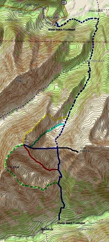
Sheep Gulch Trailhead
This trailhead provides access from the south to the standard East Ridge Route (dark blue), Southeast Ridge Route (orange) and the mostly-unexplored Southwest Ridge Route (green/dotted).
Directions (provided by miztflip): From U.S. 24 in Leadville go 19.3 miles south and turn right on Chaffee County 390. From Buena Vista go 15 miles north and turn left on to 390 (gravel.) At .2 mile you will see Clear Creek Reservoir on the left. At 7.7 miles you will pass the Missouri Gulch trailhead at Vicksburg on the left, this is the trailhead for Mt. Belford, Missouri, and Oxford. Continue 1.6 miles west and carefully locate the small dirt road on the right across from some beaver ponds,park here. Hike .2 mile up the road to the Hope Pass Trail. Finding this road is key because there is no sign. If you miss it you will get to the ghost town of Rockdale .2 mile further west.
Willis Gulch Trailhead
This trailhead provides access from the north, to the standard East Ridge Route (dotted blue), Hopeful Couloir (light blue) and Northeast Ridge Route (yellow).
Directions (from Gerry Roach: Colorado's Thirteeners): From U.S. 24, go 8.4 miles west on Colorado 82 (this is 15.3 miles east of Independence Pass, if coming from the west). Turn south onto a dirt road and follow it only 120 yards to the trailhead. According to Gerry Roach, there is plenty of parking. Simply follow the footbridge across Lake Creek and you will come to a trail sign for the Willis Gulch Trail.
Routes
Using the map to the right, here are the various route options available on Mount Hope:
BLUE--Standard East Ridge Route:
7.2 miles, 4,073 feet, Class 2
This route is accessed by the Sheep Gulch Trailhead. It follows a nice hiker's trail all the way to Hope Pass between Mount Hope and Quail Mountain. For more information see the East Ridge Route page by Kane.
BLUE/DOTTED--East Ridge Route Variation:
12.0 miles, 4,653 feet, Class 2
This route also ascends the east ridge of Mount Hope, but it begins to the north, from the Sheep Gulch Trailhead. Once again there is a nice trail to follow the whole way to the pass, however it is longer and with more elevation gain.
LIGHT BLUE--Hopeful Couloir:
11.6 miles, 4,653 feet, class 2 moderate snow
For a great spring mountaineering route on Mount Hope, try this moderate snow climb. Check out the Hopeful Couloir page by kalet for more information on this route.
ORANGE--Southeast Ridge:
6.2 miles, 4,073 feet, class 2
This route requires some bush-whacking to gain the ridge, but after that it is a nice ridge-stroll to the summit. Can be combined with the east ridge route for a nice tour. For more information see my Southeast Ridge Route page.
YELLOW--Northeast Ridge:
12.0 miles, 4,653 feet, class 2
This route can be accessed from the Willis Gulch Trailhead. According to Gerry Roach, this is the easiest route from the north. Leave the Hope Pass Trail at the small lake at 11,780 feet (not shown on map to right) and follow the ridge to the summit. If anyone has anymore first-hand information on this route it would be appreciated.
GREEN/DOTTED--Southwest Ridge:
class 3/4?
I thought I would add this route for fun. I found this route by accident while roaming around the area for the first time. Leaving the Hope Pass Trail at around 11,000 feet, bushwhack west and uphill until you attain the prominent ridge leading west to Point 13,542. The ridge is narrow at places and a fun place to explore. Just before Point 13,542, however, the hiking turns to scrambling or climbing. I turned around at this point in 2005, because of sketchy snow conditions, but it looks like a 3rd or 4th class route could be found going up these cliffs. Beware the loose rock, however. Above Point 13,542, the ridge turns abruptly north and then east to the summit of Mount Hope. It would probably make for a great loop tour if anyone else wants to try it.
BLACK--Extra Credit--Quail Mountain:
class 2
This is the standard west slope route to Quail Mountain, which can easily be tacked on to a day-hike of Mount Hope.
Forecast for theTwin Lakes area
For a ten-day forecast and current conditions of the Twin Lakes area, directly from the NOAA web site, Click Here. Remember weather conditions can change rapidly above timberline. Always be prepared!
Camping
Camping in the Twin Lakes area is plentiful. Considering the popularity of the area I will assume that an early arrival time to the campgrounds directly off of hwy 82 would be a good idea, especially on the weekends. You can actually car camp at the Willis Gulch TH if that’s your thing. The Parry Peak Campground is only another mile or two west on 82, I believe it is $10.00 a night. Go another 2 miles west on hwy 82 to the Lake Fork TH for the standard approach of La Plata Peak and turn left on FR391 and go about 1 mile south on the semi rough dirt road and there is some camping there as well, no charge. All of these campgrounds are within 4 miles of the Willis Gulch TH. There are a few places to stay in the tiny town of Twin Lakes, a bed and breakfast and some nice cabins seem to be the ones that I remember.
CAMPING- Click here for complete information on campgrounds in the Leadville Ranger District. (distance statistics per Gerry Roach.)