-
 46847 Hits
-
 89.39% Score
-
 29 Votes
|
|
Mountain/Rock |
|---|---|
|
|
46.16380°N / 10.89280°E |
|
|
Trad Climbing, Aid Climbing |
|
|
Summer |
|
|
9459 ft / 2883 m |
|
|
Overview
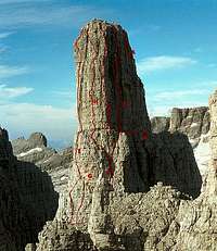
 | The most famous pinnacle of the "dolomites", it was the last of the great Dolomite peaks to be climbed. It has a very smart structure : a big cilindric pinnacle with a big shoulder on its west side. Combining a route to the shoulder with a route to the higher part you can climb for over 500m drop. This is a must for climbers : "none should speak about Dolomites climbing without having ringed the bells on its summit" (I don't remember who said it ... but it's true) No easy route, even coming down requires a good skill as you have to make a series of not easy abseils Formerly known (only by Germans) as the Guglia di Brenta, was first ascended by two young students from Innsbruck, Otto Ampferer and Karl Berger, in 1899, after some attempts that made, in 1897, Carlo Garbari, Antonio Tavernaro and Nino Pooli, get to within 150 feet of the summit. (the hardest part of the climb was named the Pooli Wall) the picture beside shows the SE face of Campanile Basso, there are about 300m (1000 ft ) between the notch and the summit |
Getting there
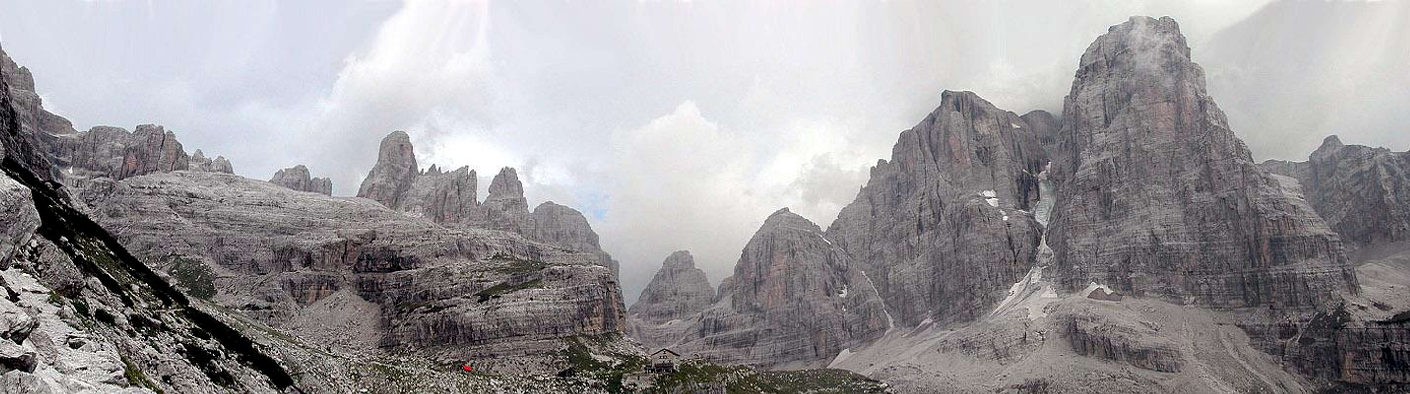
The main valley bases for the Brenta Dolomites are Madonna di Campiglio to the north west and, less convenient because much lower, Molveno to the east.for all climbs the starting point are Rifugio Brentei (2182m), Rifugio Pedrotti (2491 m) or Rifugio Alimonta (2580m)
you can get them starting from Madonna di Campiglio (1515 m) :
by car or taxi-service to Rifugio Valsinella (1513 m), then on foot (path 317) to Rif. Casinei and path 318
in 2 h walk from Vallesinella you get the Rif.Brentei
- in 1 more hour, along the wonderful path of the Bocca di Brenta you can get the Rif.Pedrotti or
- in 1 more hour, you can get the Rif: Alimonta
You can find all info about Refuges at :
Rifugi
(multilingual)
Routes overview
| Routes to the summit Routes to the summit starting from the shoulder or from the big ledge (stradone provinciale) | ||
 | Routes to the shoulder |

small and simple comparison table of difficulties
| UIAA | French | USA |
| 1° | F | 2 |
| 2° | PD | 3 - 4 |
| 3°inf - 3° - 3° sup | AD | 5 - 5.2 |
| 4° inf - 4° - 4° sup | D | 5.3 - 5.5 |
| 5° inf - 5° - 5° sup | TD | 5.6 - 5.8 |
| 6° inf - 6° - 6° sup | ED | 5.9 - 5.11 |
| 7° | EX | 5.11a - 5.11b |
When to go
The best period, when snow and ice is likely to be the least trouble, is July – September.Normal route on Campanile Basso is often crowdy. To be the first it's better to start the climb early in the morning (8.30-9.00 am); the face is a little cold but it's better a good pile than a long wait...
comment by fasterhigher
On the contrary, but only if you are a fast climber and already know how to get down, the Fehrmann route is very fine in the afternoon, starting the climb when sun has already made the rock hot ... of course if weather is very good :)
Update - august 2005 - it looks like climbing here is "out of fashion" .. very few rope teams on the routes ...
Accomodations
Camping is available in S. Antonio di Mavignola (Campeggio Faè, +39-0465-507178)Place for motorhomes and campers near the cable-car starting point in Campo Carlo Magno
Unauthorized camping and wild camping are not normally allowed ... but near the Brentei none will tell you anything if you place a tent to spend the night , but the refuge is much more comfortable and not expensive
Red tape
No permits are required.Recommended Guidebooks
'Classic Dolomite Climbs' by Anette Kohler and Norbert Memmel.Seattle : The Mountaineers ; London : Baton Wicks, 1998. Adapted from a translation by Tim Carruthers.
'Dolomites - Selected Climbs' by Ron James. General editor : Les Swindin.
London : The Alpine Club, 1988.
the best (a true "Bible") book of the Group I think is the :
Guida dei Monti d'Italia - by Gino Buscaini and Ettore Castiglioni
DOLOMITI di BRENTA
CAI - TCI
Italy - 1977
can be still found in Madonna di campiglio shops
special thanks
to Tony Simpkinswho, with an e-mail, has invited me to take over this page :
"I would prefer it if the page was taken over by someone like yourself ... "
"I have done the transfer ... Good luck"