Overview
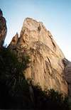
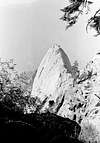
E = Extreme heat, P = Poison Oak, I = Irritating Insects, C = Cool Head....(runout pro!), S = Snakes! Bold, unrelenting, captivating, EPIC!! This is what goes on inside most climbers heads when they get their first eyeful of The Fin. For those who enjoy suffering, this blade of granite has your name written all over it! Located in Sequoia National Park, The Fin and it's next door neighbor, Castle Rock Spire, have been the subject matter of photographers, naturalists and adventuresome climbers. The Fin is just part of the granite landscape along the Great Western Divide. Placed on the south slopes of the Middle Fork of the Kaweah River, The Fin's approach is heavily guarded by steep cross-country terrain, groves of skin-piercing manzanita, ever-present poison oak, blood sucking ticks, debilitating heat and deviant diamondback rattlesnakes! And if you don't think that is enough, water sources are few and far between. But once at the base of this sweeping backcountry dome, you'll be forgetting what was once behind and gaggling to grope the gregarious granite. It's most "popular" route, 'Silver Lining', is by far the most treasured yet most unforgiving path upon it's flanks. Silver Lining boasts of 50 to 60 foot runout sections on fairly sustained 5.9 terrain. And the features are similar to that upon most Tuolumne domes (ie small dishes and depressions, small flairing underlaps etc). This route (as of June 2002) has only seen it's 18th ascent. Castle Rock Spire has seen even fewer and has been the center of discussion as to "what Sierra summit is the most difficult to climb by it's easiest route" (Regular Route IV 5.11 or 5.9 A2). Of those exceptionally few who have completed routes on The Fin, all have claimed it to be one of the best backcountry experiences ever! A quote from the most recent ascent party: "Overall, we thought the area was fantastic and wild with great climbing, but it's approach is destined to keep it very unpopular". Adventure awaits.......
Getting There
The start of this long apporach begins at the Paradise Creek Trailhead at the back end of the Buckeye Flat Campground. Be sure to fill up the water bottles/Camelbaks before hitting the trailhead. The Middle Fork Kaweah drainage is well-known for its stagnating heat and lack of H2O. Once on the Paradise Creek trail, it will cross over a branch of the Middle Fork Kaweah River then on over to Paradise Creek. The trail follows the creek for approximately 2 miles. Look for a faint trail heading east and away from the creek at this point. Follow it up a steep, grassy ridge and eventually past a LARGE burnt oak tree. Once past the oak tree, look carefully for the long abandoned Castle Rock trail. Follow this overgrown trail for approximately 4 miles as it contours the eastern landscape before passing three small gullies. The last boulder strewn gully turns southeast and upward toward the notch between The Fin and Castle Rock Spire. Approach the western apron of The Fin by hiking this gully midway up then traverse back left (north). For routes to Castle Rock Spire, continue up the remaining part of the gully to the notch (3rd/4th class snow, when in season) and 4th and 5th class when no snow is present.
Red Tape
Park all vehicles at the Hospital Rock parking lot. The NPS will not permit vehicles to be parked in the Buckeye Flat campgrounds unless the vehicle is registered to a designated campsite or an Overnight Wilderness Permit has been acquired. All vehicles are subject to citation if they are not in compliance. Buckeye Flat campground is subject to closure if the snow line drops to that level. With the later being true, one may park their vehicle under that condition and next to the gate. Also, bears are active in this area of the park. Be sure to secure your vehicle properly and obey park regulations.
When To Climb
Considering the long approach, initial trailhead elevation (2800' feet) and the San Joaquin valley heat index........SPRING is the best time for climbing The Fin. Water is available and the weather is fairly stable. However, cold spells have been known to last well into the later part of May!! But rest assured, the insect population will be low in numbers. On sunny spring days or late fall, be on the sharp lookout for rattlesnakes! (see trip report by Craig Clarence).
Camping
Camping is available at the Potwisha or Buckeye Flat campground. The later being the best choice for the approach. Location, cost per night and additional information can be viewed on the
NPS Visitor web page.
Mountain Conditions
The main concern is not so much The Fin itself but the initial approach. Poison oak is everywhere and ticks are always looking to hitch hike on a body part. Be sure to bring some DEET. Not only will this ward off most of the mosquitoes but prevent ticks from burrowing into the skin. The Middle Fork of the Kaweah is also a watershed. Campfires are NOT permitted in this area. Careless hikers started the 1980 Paradise Valley fire.
Miscellaneous Info
For further details or information relating to The Fin,
Castle Rock Spire or surrounding features (ie The Keep, The Axe), consult R.J. Secor's "High Sierra: Peaks, Passes And Trails".
External Links


Jack Daniels - Jan 13, 2003 6:49 pm - Hasn't voted
Untitled CommentA few comments:
The Fin may have seen only 18 ascents, but on Castle Rock Spire there have been something on the order of a few dozen parties in the past 50 years.
Heat: sure it can be bad, but we were there June 7-9 in 2002 and it was actually just fine. Perfect temperatures actually. Craig Clarence & Co. hit a heat wave, but we missed it. If you go much earlier, you may have to concern yourselves with taking some sharp metal thingies to deal with potential snow/ice in the gully leading up to CRS (probably not as much of an issue with The Fin). A friend tried to climb CRS in mid May a few years back and spent 4 hrs climbing the ice in the gully. They had just one ice axe and no crampons and this doomed their attempt. In early June 2002, it was possible to avoid the ice. Of course this is also a function of the snowfall for the year. And in my case, an ice axe was still handy for the approach as a walking stick, to beat back the poison oak, to help hang the food at camp, and to downclimb an 80 degree dirt slope we blundered into on the way out.
We used a combination of DEET and Black Flag (on our clothes) and had only one tick incident. Poison oak we dealt with as per our susceptibilities. My friend essentially ignored it, despite falling in it, and had no rash. On a scale of 1 to 10, I'm probably an 8 in terms of being allergic to the stuff. I wore a Tyvek biohazard suit, stripped naked after we passed the last bit of poison oak and washed my entire body and clothes in Tecnu, and then repeated this for the trip out. I got a tiny bit of poison oak in the middle of my back. We also saw (and nearly stepped on) one small 4 foot rattlesnake.
We only climbed CRS, but The Fin is an absolutely beautiful, stunning wall of granite. I was transfixed by it and actually got dizzy looking at it during our climb.