
|
|
Mountain/Rock |
|---|---|
|
|
44.20310°N / 71.3747°W |
|
|
4052 ft / 1235 m |
|
|
Overview
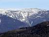
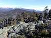
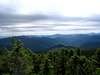
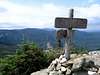
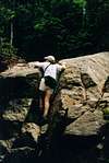
Mt. Jackson ranks 38 on the official New Hamsphire 4000 footer list, and lies in the southern Presidential Range along the Appalachian Trail. The summit can be reached from a number of trails, several of which provide interesting loop trails with neighboring summits, particularly Mt. Pierce and Mt. Webster. The peak affords excellent views to the north and Mt. Washington, to the west towards the Pemigewasset Range, and to the east towards Maine. The trails are crossed by several streams, and there are views from the cliffs towards Crawford Notch and the Willey Range. Please refer to the Presidential Range page for an excellent overview of the area.
Mt. Jackson is named for Charles Jackson, a 19th-century New Hampshire State Geologist, and not, as one would assume, for President Andrew Jackson.
 |
 |
 |
 |
Getting There
The major trails for Mt. Jackson all originate from N.H. Route 302. From the south, take Route 93 to Route 3 just after Franconia Notch and turn right on Route 302. From the east, take Route 302 from N.H. Route 16 in N. Conway and travel to Crawford Notch.
The Trails
Mt. Jackson can be reached from the Webster-Jackson Trail or from the Webster Cliff Trail.
Webster Jackson Trail starts at Route 302 at the northwest end of the Crawford Notch State Park. The parking lot, which is about .25 miles from the Highland Center at Crawford Notch (see Accomodations, below), is across the highway from the trailhead. The trail, blazed in blue, climbs 1.4 miles to the trail junction, where the choice is left towards Mt. Jackson or right towards Mt. Webster. The two peaks are joined by the Webster Cliff Trail, affording an easy loop over two peaks. The total distance for the loop is 6.5 miles, with 2500 feet of climbing.
Webster Cliff Trail begins at Route 302 about 1 mile south of the Willey House Recreation Area. The trail climbs steeply up to the ridge along the cliffs overlooking Crawford Notch. The trail reaches the top of Mt. Webster at 3.3 miles, the junction with the Webster-Jackson trail shortly thereafter, and then Jackson at 4.7 miles. The trail continues on to the Mitzpah Spring Hut at 6.4 miles, and the Crawford Path at 7.3 miles.
Jackson is often combined with Mt. Pierce, combining the Crawford Path, Webster Cliff Trail, and Webster-Jackson Trail. Loop distance is 8.3 miles, with a little walking on Route 302 to get back to your car.
Click here for more trail ideas in this area.
 |
Red Tape
There are several free parking lots in the Crawford Notch State Park on Route 302. The Clinton Road parking lot located near the Crawford Path is governed by U.S. Forest Service rules, and requires $3.00 per day or a parking pass. Check here for more detail on the fees.
Camping is prohibited within the Crawford Notch State Park, except in the Dry River Campground (see below). Camping in the White Mountain National Forest is governed by National Forest Service rules. Forest Protection Areas, near trailheads and accomodations, which are clearly marked, are heavily restricted. Check the rules for other restrictions.
In general: No camping above treeline, except in winter and then only when there is two feet of snow on the ground. No camping within 1/4 mile of established huts, campsites, trailhead, or certain roads. Bring a campstove and avoid open fires. Camp away from water.
When To Climb
As with the other White Mountains, Mount Jackson is a four season experience. Spring brings mud and high water; early summer means bugs; winter means bring snow shoes and crampons and the rest of your usual winter gear. The summit is exposed, and there is a likelihood of ice on the steep approaching ledges. As always, prepare for changing weather.
Although there is abundant water along this trail, precautions should always be taken to filter or treat the water. The stream crossings may prove challenging during high water.
Camping, Huts, and Other Accomodations
There are abundant rustic accomodatons and camping opportunities in the area surrounding Mt. Jackson.
The Dry River Campground is located on Route 302 in Crawford Notch State Park, with 36 sites, reservations available, and many accomodations. Open May 6 to December 1.
Just north of the trails is the Highland Center at Crawford Notch, operated by the AMC and open year-round, with room for over 120 guests. 603-466-2727. Rates from $25 per night. Check here for rates and availability.
Traveling north along the Appalachian Trail, the Mitzpah Spring Hut, which lies between Mt. Jackson and Mt. Eisenhower and which is operated by the AMC, accomodates 60 people.
Back country camping is permitted in the White Mountain National Forest, but, in addition to the restrictions in the well-marked Forest Protection Areas, you should be familiar with the other Forest Service regulations.
Mountain Conditions
Current conditions are available from the Mt. Washington Observatory. Check the Higher Summits Forecast.
Current New Hampshire Trail Conditions: Views From The Top.
Numerous White Mountain resources: Appalachian Mountain Club
More Weather Information
Current conditions in nearby North Conway: 10-day Forecast